Published on
|
|
|
Alpha Project Bahia, Brazil Technical Report Summary |


Contents
1.0 |
EXECUTIVE SUMMARY |
1-1 |
|
1.1 |
Introduction |
1-1 |
|
1.2 |
Terms of Reference |
1-1 |
|
1.3 |
Property Setting |
1-1 |
|
1.4 |
Ownership |
1-2 |
|
1.5 |
Mineral Tenure, Surface Rights, Water Rights, Royalties and Agreements |
1-2 |
|
1.6 |
Environmental, Permitting and Social Considerations |
1-3 |
|
1.7 |
Geology and Mineralization |
1-4 |
|
1.8 |
History |
1-6 |
|
1.9 |
Exploration |
1-7 |
|
1.10 |
Drilling and Sampling |
1-7 |
|
1.11 |
Data Verification |
1-9 |
|
1.12 |
Metallurgical Testwork |
1-9 |
|
1.12.1 |
|
Ionic Adsorption Clay Processing |
1-9 |
1.12.2 |
|
Metallurgical Testwork |
1-10 |
1.13 |
Mineral Resource Estimation |
1-11 |
|
1.13.1 |
|
Estimation Methodology |
1-11 |
1.13.2 |
|
Market Assessment |
1-13 |
1.13.3 |
|
Mineral Resource Statement |
1-14 |
1.13.4 |
|
Factors That May Affect the Mineral Resource Estimate |
1-14 |
1.14 |
Risks |
1-15 |
|
1.14.1 |
|
Exploration and Geology Risks |
1-15 |
1.14.2 |
|
Mineral Resource Estimate Risks |
1-15 |
1.14.3 |
|
Environmental, Social and Permitting Risks |
1-16 |
1.15 |
Opportunities |
1-16 |
|
1.15.1 |
|
Exploration and Geology Opportunities |
1-16 |
1.15.2 |
|
Mineral Resource Opportunities |
1-17 |
1.16 |
Conclusions |
1-17 |
|
1.17 |
Recommendations |
1-18 |
|
2.0 |
INTRODUCTION |
2-1 |
|
2.1 |
Introduction |
2-1 |
|
2.2 |
Terms of Reference |
2-1 |
|
2.2.1 |
|
Report Purpose |
2-1 |
2.2.2 |
|
Terms of Reference |
2-1 |
2.3 |
Qualified Persons |
2-1 |
|
2.4 |
Site Visits and Scope of Personal Inspection |
2-3 |
|
2.4.1 |
|
McGarry Geoconsulting Corp. |
2-3 |
2.4.2 |
|
Karst Geo Solutions |
2-3 |
2.5 |
Report Date |
2-3 |
|
2.6 |
Information Sources and References |
2-3 |
|
2.7 |
Previous Technical Report Summaries |
2-4 |
|
3.0 |
PROPERTY DESCRIPTION |
3-1 |
|
Date: 31 October 2025 |
|
ii |
|
|
|
Alpha Project Bahia, Brazil Technical Report Summary |
3.1 |
Introduction |
3-1 |
|
3.2 |
Property and Title in Bahia |
3-1 |
|
Overview |
3-1 |
||
3.2.1 |
|
Mineral Title |
3-1 |
3.2.2 |
|
Surface Rights |
3-3 |
3.2.3 |
|
Water Rights |
3-3 |
3.2.4 |
|
Government Mining Taxes, Levies or Royalties |
3-4 |
3.3 |
Ownership |
3-4 |
|
3.4 |
Mineral Title |
3-4 |
|
3.5 |
Surface Rights |
3-8 |
|
3.6 |
Water Rights |
3-8 |
|
3.7 |
Royalties |
3-9 |
|
3.8 |
Encumbrances |
3-9 |
|
3.9 |
Environmental Considerations |
3-9 |
|
3.9.1 |
|
Baseline Studies |
3-10 |
3.10 |
Permitting Considerations |
3-10 |
|
3.10.1 |
|
Permitting Requirements |
3-10 |
Next Permitting Milestones |
3-10 |
||
Future Permitting Milestones |
3-11 |
||
3.10.2 |
|
Permitting Timelines |
3-11 |
3.10.3 |
|
Permit Conditions |
3-11 |
3.10.4 |
|
Violations and Fines |
3-12 |
3.11 |
Social Considerations |
3-12 |
|
3.12 |
Significant Factors and Risks That May Affect Access, Title, or Work Programs |
3-13 |
|
4.0 |
ACCESSIBILITY, CLIMATE, LOCAL RESOURCES, INFRASTRUCTURE AND PHYSIOGRAPHY |
4-1 |
|
4.1 |
Physiography |
4-1 |
|
4.1.1 |
|
Topography and Elevation |
4-1 |
4.1.2 |
|
Vegetation |
4-1 |
4.2 |
Accessibility |
4-2 |
|
4.3 |
Climate |
4-2 |
|
4.3.1 |
|
Length of Operating Season |
4-2 |
4.4 |
Infrastructure |
4-3 |
|
4.4.1 |
|
Water |
4-3 |
4.4.2 |
|
Electricity and Power |
4-3 |
4.4.3 |
|
Personnel |
4-3 |
4.4.4 |
|
Supplies |
4-4 |
5.0 |
HISTORY |
5-1 |
|
6.0 |
GEOLOGICAL SETTING, MINERALIZATION, AND DEPOSIT |
6-1 |
|
6.1 |
Deposit Type |
6-1 |
|
6.2 |
Regional Geology |
6-1 |
|
6.3 |
Local Geology |
6-3 |
|
6.3.1 |
|
Volta do Rio Suite |
6-3 |
6.4 |
Structure |
6-3 |
|
6.5 |
Regolith Profile |
6-4 |
|
6.6 |
Deposit Descriptions |
6-6 |
|
6.6.1 |
|
Rio Preto Deposit |
6-6 |
Date: 31 October 2025 |
|
iii |
|
|
|
Alpha Project Bahia, Brazil Technical Report Summary |
Deposit Dimensions |
6-6 |
||
Bedrock Geology |
6-7 |
||
Regolith and Weathering |
6-7 |
||
Mineralization |
6-7 |
||
6.6.2 |
|
Sapacaia Deposit |
6-8 |
Deposit Dimensions |
6-8 |
||
Bedrock Geology |
6-8 |
||
Regolith and Weathering |
6-9 |
||
Mineralization |
6-9 |
||
6.6.3 |
|
Nova Canaã Deposit |
6-10 |
Deposit Dimensions |
6-10 |
||
Bedrock Geology |
6-10 |
||
Regolith and Weathering |
6-11 |
||
Mineralization |
6-11 |
||
6.6.4 |
|
Rio das Pombas Deposit |
6-12 |
Deposit Dimensions |
6-12 |
||
Bedrock Geology |
6-12 |
||
Regolith and Weathering |
6-14 |
||
Mineralization |
6-14 |
||
7.0 |
EXPLORATION |
7-1 |
|
7.1 |
Exploration |
7-1 |
|
7.1.1 |
|
Grids and Surveys |
7-1 |
7.1.2 |
|
Geological Mapping |
7-1 |
7.1.3 |
|
Airborne Geophysics |
7-1 |
7.1.4 |
|
Geochemistry |
7-2 |
7.1.5 |
|
Qualified Person’s Interpretation of the Exploration Information |
7-2 |
7.1.6 |
|
Exploration Potential |
7-5 |
Ionic Clay Mineralization |
7-5 |
||
Secondary Monazite in Regolith |
7-5 |
||
7.2 |
Drilling |
7-7 |
|
7.2.1 |
|
Overview |
7-7 |
Drilling Used in Estimation |
7-7 |
||
Drilling Excluded for Estimation Purposes |
7-7 |
||
Drilling Methods |
7-8 |
||
Drilling Since Database Cut-off Date |
7-8 |
||
7.2.2 |
|
Drill Methods |
7-8 |
Auger |
7-10 |
||
Sonic |
7-10 |
||
Core Drilling |
7-11 |
||
7.2.3 |
|
Logging |
7-11 |
7.2.4 |
|
Recovery |
7-12 |
7.2.5 |
|
Collar Surveys |
7-12 |
7.2.6 |
|
Down Hole Surveys |
7-12 |
7.2.7 |
|
Drilled Versus True Thickness |
7-12 |
7.2.8 |
|
Drill Hole Spacing |
7-12 |
7.2.9 |
|
Comment on Material Results and Interpretation |
7-13 |
Date: 31 October 2025 |
|
iv |
|
|
|
Alpha Project Bahia, Brazil Technical Report Summary |
7.3 |
Hydrogeology |
7-14 |
|
7.4 |
Geotechnical |
7-14 |
|
8.0 |
SAMPLE PREPARATION, ANALYSES, AND SECURITY |
8-1 |
|
8.1 |
Sampling Methods |
8-1 |
|
8.1.1 |
|
Auger |
8-1 |
8.1.2 |
|
Sonic and Core |
8-1 |
8.1.3 |
|
Grab Samples |
8-1 |
8.2 |
Sample Security Methods |
8-2 |
|
8.3 |
Density Determinations |
8-2 |
|
8.4 |
Analytical and Test Laboratories |
8-3 |
|
8.5 |
Sample Preparation |
8-3 |
|
8.6 |
Analysis |
8-3 |
|
8.7 |
Quality Assurance and Quality Control |
8-4 |
|
8.7.1 |
|
Certified Reference Materials |
8-5 |
CRM Results SGS Geosol IMS95A |
8-5 |
||
CRM Results ALS ME-MS81 |
8-9 |
||
8.7.2 |
|
Blanks |
8-11 |
Blank SGS IMS95A |
8-11 |
||
Blank ALS ME-MS81 |
8-12 |
||
8.7.3 |
|
Field Duplicates |
8-13 |
Field Duplicates SGS Geosol IMS95A |
8-13 |
||
Field Duplicates ALS Lima |
8-13 |
||
8.8 |
Database |
8-14 |
|
8.9 |
Qualified Person’s Opinion on Sample Preparation, Security, and Analytical Procedures |
8-16 |
|
9.0 |
DATA VERIFICATION |
9-1 |
|
9.1 |
Internal Data Verification |
9-1 |
|
9.1.1 |
|
Exploration Data |
9-1 |
9.2 |
Data Verification by Qualified Person |
9-1 |
|
9.2.1 |
|
Karst Geo Solutions |
9-1 |
9.2.2 |
|
McGarry Geoconsulting |
9-1 |
10.0 |
MINERAL PROCESSING AND METALLURGICAL TESTING |
10-1 |
|
10.1 |
Introduction |
10-1 |
|
10.2 |
Proposed Processing Method |
10-1 |
|
10.3 |
Test Laboratories |
10-2 |
|
10.4 |
Metallurgical Testwork |
10-3 |
|
10.5 |
Rare Earth Element Extraction Estimates |
10-4 |
|
10.6 |
Metallurgical Variability |
10-7 |
|
10.7 |
Deleterious Elements |
10-7 |
|
10.8 |
Qualified Person’s Opinion on Data Adequacy |
10-8 |
|
11.0 |
MINERAL RESOURCE ESTIMATES |
11-1 |
|
11.1 |
Introduction |
11-1 |
|
11.2 |
Unsampled Intervals |
11-2 |
|
11.3 |
Univariate Statistics |
11-2 |
|
11.4 |
Assay Summary Statistics |
11-5 |
|
11.5 |
Geological Models |
11-9 |
|
11.5.1 |
|
Density Assignment |
11-9 |
Date: 31 October 2025 |
|
v |
|
|
|
Alpha Project Bahia, Brazil Technical Report Summary |
11.5.2 |
|
Grade Capping/Outlier Restrictions |
11-9 |
11.6 |
Composites |
11-9 |
|
11.7 |
Variography |
11-10 |
|
11.8 |
Estimation/interpolation Methods |
11-11 |
|
11.9 |
Validation |
11-12 |
|
11.9.1 |
|
Visual Validation |
11-12 |
11.9.2 |
|
Comparison of Means |
11-15 |
11.9.3 |
|
Swath Plots |
11-16 |
11.10 |
Confidence Classification of Mineral Resource Estimate |
11-17 |
|
11.10.1 |
|
Mineral Resource Confidence Classification |
11-17 |
11.11 |
Reasonable Prospects of Economic Extraction |
11-20 |
|
11.11.1 |
|
Initial Assessment Assumptions |
11-20 |
11.11.2 |
|
Constraining Potentially Mineable Shape Input Assumptions |
11-24 |
11.11.3 |
|
Market and Commodity Price Forecasts |
11-24 |
General Uses and Products |
11-24 |
||
Market Overview and Principal Users |
11-25 |
||
Marketability and Pricing |
11-26 |
||
Price Forecasts |
11-26 |
||
Payability |
11-27 |
||
Basket Value Estimation |
11-27 |
||
11.11.4 |
|
Pit Shell |
11-28 |
11.11.5 |
|
Cut-off |
11-29 |
11.11.6 |
|
QP Statement |
11-30 |
11.12 |
Mineral Resource Statement |
11-30 |
|
11.13 |
Uncertainties (Factors) That May Affect the Mineral Resource Estimate |
11-31 |
|
12.0 |
MINERAL RESERVE ESTIMATES |
12-1 |
|
13.0 |
MINING METHODS |
13-1 |
|
14.0 |
RECOVERY METHODS |
14-1 |
|
15.0 |
INFRASTRUCTURE |
15-1 |
|
16.0 |
MARKET STUDIES AND CONTRACTS |
16-1 |
|
17.0 |
ENVIRONMENTAL STUDIES, PERMITTING, AND PLANS, NEGOTIATIONS, OR AGREEMENTS WITH LOCAL INDIVIDUALS OR GROUPS |
17-1 |
|
18.0 |
CAPITAL AND OPERATING COSTS |
18-1 |
|
19.0 |
ECONOMIC ANALYSIS |
19-1 |
|
20.0 |
ADJACENT PROPERTIES |
20-1 |
|
21.0 |
OTHER RELEVANT DATA AND INFORMATION |
21-1 |
|
22.0 |
INTERPRETATION AND CONCLUSIONS |
22-1 |
|
22.1 |
Introduction |
22-1 |
|
22.2 |
Property Setting |
22-1 |
|
22.3 |
Ownership |
22-1 |
|
22.4 |
Mineral Tenure, Surface Rights, Water Rights, Royalties and Agreements |
22-1 |
|
22.5 |
Geology and Mineralization |
22-2 |
|
22.6 |
History |
22-3 |
|
22.7 |
Exploration, Drilling, and Sampling |
22-3 |
|
22.8 |
Data Verification |
22-4 |
|
22.9 |
Metallurgical Testwork |
22-4 |
|
Date: 31 October 2025 |
|
vi |
|
|
|
Alpha Project Bahia, Brazil Technical Report Summary |
22.10 |
Mineral Resource Estimates |
22-4 |
|
22.11 |
Risks |
22-5 |
|
22.11.1 |
|
Exploration and Geology Risks |
22-5 |
22.11.2 |
|
Mineral Resource Estimate Risks |
22-6 |
22.11.3 |
|
Environmental, Social and Permitting Risks |
22-6 |
22.12 |
Opportunities |
22-7 |
|
22.12.1 |
|
Exploration and Geology Opportunities |
22-7 |
22.12.2 |
|
Mineral Resource Opportunities |
22-7 |
22.13 |
Conclusions |
22-7 |
|
23.0 |
RECOMMENDATIONS |
23-1 |
|
23.1 |
Introduction |
23-1 |
|
23.2 |
Phase A |
23-1 |
|
23.3 |
Phase B |
23-2 |
|
24.0 |
REFERENCES |
24-1 |
|
24.1 |
Bibliography |
24-1 |
|
24.2 |
Abbreviations and Units of Measure |
24-2 |
|
24.3 |
Glossary of Terms |
24-4 |
|
25.0 |
RELIANCE ON INFORMATION PROVIDED BY THE REGISTRANT |
25-1 |
|
25.1 |
Introduction |
25-1 |
|
25.2 |
Mineral Processing |
25-1 |
|
25.3 |
Markets |
25-1 |
|
25.4 |
Legal Matters |
25-1 |
|
25.5 |
Environmental Matters |
25-2 |
|
25.6 |
Stakeholder Accommodations |
25-2 |
|
25.7 |
Governmental Factors |
25-2 |
|
Date: 31 October 2025 |
|
vii |
|
|
|
Alpha Project Bahia, Brazil Technical Report Summary |
Tables
Table 1‑1: |
Alpha Project Mineral Resource Estimate |
1-14 |
Table 2‑1: |
QP Responsibilities |
2-2 |
Table 3‑1: |
Mineral Concession Summary Table |
3-6 |
Table 6‑1: |
Stratigraphic Column Through Weathering Profile |
6-5 |
Table 7‑1: |
2023 Summary of Surface Samples |
7-2 |
Table 7‑2: |
Intercepts with Geochemical Indicative of Secondary Monazite Mineralization |
7-7 |
Table 7‑3: |
Drill Summary Table Supporting Mineral Resource Estimates |
7-10 |
Table 7‑4: |
Summary of water-related drilling stoppages in deposit areas |
7-14 |
Table 8‑1: |
Bulk Density Determinations |
8-3 |
Table 8‑2: |
Elemental Detection Limits, SGS Geosol and ALS Lima |
8-4 |
Table 8‑3: |
SGS IMS95A Results: OREAS 25a |
8-5 |
Table 8‑4: |
SGS IMS95A Results: OREAS 30a |
8-6 |
Table 8‑5: |
SGS IMS95A Results: OREAS 100a |
8-6 |
Table 8‑6: |
SGS IMS95A Results: OREAS 106 |
8-7 |
Table 8‑7: |
SGS IMS95A Results: OREAS 147 |
8-7 |
Table 8‑8: |
SGS IMS95A Results: OREAS 460 |
8-8 |
Table 8‑9: |
ALS ME-MS81 Results: OREAS 30a |
8-9 |
Table 8‑10: |
ALS ME-MS81 Results: OREAS 100a |
8-9 |
Table 8‑11: |
ALS ME-MS81 Results: OREAS 147 |
8-10 |
Table 8‑12: |
ALS ME-MS81 Results: OREAS 460 |
8-10 |
Table 10‑1: |
Mean Leach Sample Recoveries by Deposit |
10-5 |
Table 10‑2: |
Mean Block Model Recovery Estimates |
10-6 |
Table 10‑3: |
Deleterious Element U and Th in Pregnant Leach Solution in Bench-Scale Tests |
10-8 |
Table 11‑1: |
Extents of the Mineral Resource Estimate Domains |
11-2 |
Table 11‑2: |
Composite Rare Earth Element Statistics (all values in ppm) |
11-3 |
Table 11‑3: |
Composite Statistics for Rare Earth Element Reporting Groups and Deleterious Element Grades (all values in ppm) |
11-4 |
Table 11‑4: |
Summary Statistics for Rare Earth Element Assays (all values in ppm) |
11-6 |
Table 11‑5: |
Summary Statistics for Rare Earth Element Reporting Groups and Deleterious Elements |
11-6 |
Date: 31 October 2025 |
|
viii |
|
|
|
Alpha Project Bahia, Brazil Technical Report Summary |
Table 11‑6: |
Correlation Matrix, Rare Earth Element Assays |
11-8 |
Table 11‑7: |
Search Parameters |
11-11 |
Table 11‑8: |
Search Ranges and Clamping Restrictions |
11-11 |
Table 11‑9: |
Comparison of Means for Rio Preto and Sapacaia Domains |
11-15 |
Table 11‑10. |
Sources of Mineral Resource Uncertainty |
11-18 |
Table 11‑11: |
Initial Assessment Assumptions |
11-21 |
Table 11‑12: |
Rare-Earth Elements Prices and Average Basket Price Calculation |
11-27 |
Table 11‑13: |
Whittle Resource Constraining Pit Shell Parameters |
11-28 |
Table 11‑14: |
Alpha Project Mineral Resource Estimate |
11-30 |
Table 23‑1: |
Budget for Phase A Work Program |
23-2 |
Table 23‑2: |
Budget for Phase B Work Program |
23-3 |
Date: 31 October 2025 |
|
ix |
|
|
|
Alpha Project Bahia, Brazil Technical Report Summary |
Figures
Figure 2‑1: |
Project Location Plan |
2-2 |
Figure 3‑1: |
Mineral Tenure Location Plan |
3-7 |
Figure 6‑1: |
Regional Geology Plan |
6-2 |
Figure 6‑2: |
Example Strip Log Stratigraphy, Drill Hole ST10944 (left) and Schematic Ionic Adsorption Clay Model (right) |
6-6 |
Figure 6‑3: |
Example Geological Cross Section Rio Preto |
6-7 |
Figure 6‑4: |
Example Geological Cross-Section Sapacaia |
6-9 |
Figure 6‑5: |
Sapacaia Secondary REE Mineral Zone Geological Cross-Section |
6-10 |
Figure 6‑6: |
Example Geological Cross-Section Nova Canaã |
6-11 |
Figure 6‑7: |
Example Geological Long-Section Rio das Pombas North |
6-13 |
Figure 6‑8: |
Example Geological Long-Section Rio das Pombas South |
6-13 |
Figure 7‑1: |
Surface Sample Location Map |
7-4 |
Figure 7‑2: |
Secondary Monazite Mineralization Occurrences |
7-6 |
Figure 7‑3: |
Property Drill Collar Location Plan |
7-9 |
Figure 8‑1: |
SGS Example CRM Control Plot OREAS 100a |
8-8 |
Figure 8‑2: |
ALS Example CRM Control Plot OREAS 100a |
8-11 |
Figure 8‑3: |
SGS Control Plot Blanks |
8-12 |
Figure 8‑4: |
ALS Control Plot Blanks |
8-13 |
Figure 8‑5: |
SGS Field Duplicate Scatter Plots |
8-14 |
Figure 8‑6: |
ALS Field Duplicate Scatter Plots |
8-15 |
Figure 10‑1: |
Collar Locations, Metallurgical Testwork Samples |
10-4 |
Figure 10‑2: |
Summary of Leach Test Results for Above Mineral Resource Estimate Threshold Samples |
10-6 |
Figure 11‑1: |
TREO, HREO, Nd2O3, Pr6O11, Dy2O3 and Tb4O7 Assay Log Histograms |
11-7 |
Figure 11‑2: |
Log Probability Plot, Sample Lengths |
11-10 |
Figure 11‑3: |
Plan View of Largest Block Models Colored by Total Rare Earth Oxide Grade |
11-13 |
Date: 31 October 2025 |
|
x |
|
|
|
Alpha Project Bahia, Brazil Technical Report Summary |
Figure 11‑4: |
Cross-Section Views of the Block Model Colored by Total Rare Earth Oxide Grade |
11-14 |
Figure 11‑5: |
Swath Plots Rio Preto and Sapacaia Composite Nd2O3 Values Vs. ID3 and OK Estimates |
11-16 |
Figure 11‑6: |
Swath Plots Nova Canaã Composite Nd2O3 Values Vs. ID3 and OK Estimates |
11-17 |
Figure 11‑7: |
Swath Plots Rio das Pombas Composite Nd2O3 Values Vs. ID3 and OK Estimates |
11-17 |
Figure 11‑8: |
Classified Block Distances from Drill Hole |
11-20 |
Figure 11‑9: |
Forecast Global NdPr Oxide Production and Demand |
11-25 |
Figure 11‑10: |
Forecast Global Dysprosium Oxide Production and Demand |
11-25 |
Date: 31 October 2025 |
|
xi |
|
|
|
Alpha Project Bahia, Brazil Technical Report Summary |
1.0 EXECUTIVE SUMMARY
1.1 Introduction
This technical report summary (the Report) was prepared by McGarry Geoconsulting Corp. and Karst Geo Solutions, LLC for Rare Earths Americas, Inc. (Rare Earths Americas) on the Alpha Project (the Project) in Bahia, Brazil.
1.2 Terms of Reference
The Report was prepared to support the filing by Rare Earth Americas of a registration statement on Form S-1 with the Securities and Exchange Commission, pursuant to Section 1300 of Regulation S-K.
The Report provides initial disclosure of mineral resource estimates for rare earth element mineral deposits at four areas within the Alpha Project: Rio Preto, Sapacaia, Nova Canaã, and Rio das Pombas.
Unless otherwise indicated, the metric system is used in this report for mineral resources. Mineral resources are reported using the definitions in Regulation S–K 1300 (SK1300), under Item 1300. Monetary values use the United States (US) dollar unless otherwise indicated. The Brazilian currency is the real (BRL). The Report uses United States English.
1.3 Property Setting
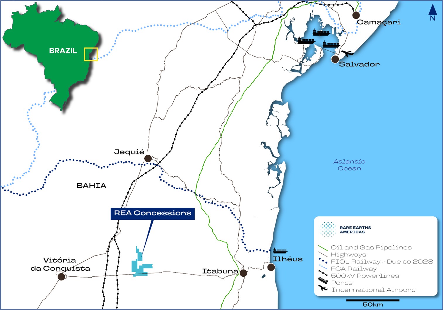
The Project is located approximately 270 km southwest of Salvador, the capital of Bahia State in northeastern Brazil. The Project concessions lie within the municipal boundaries of Iguaí and Nova Canaã, provincial towns situated immediately east of the Project area.
Elevations in the Project area range from 400–900 meters above sea level (masl) and include both gently undulating and sloped terrain, as well as areas with greater relief.
All Rare Earth Americas concessions are within approximately 35 km of Brazil's major federal highway BR-116 to the west and 80 km of BR-101 to the east. These highways provide direct access to the country's key infrastructure and industrial centers. The concessions can be easily reached from either highway, first by paved highway BA-262 which passes through the Sapacaia, Nova Canaã and Rio das Pombas deposits; and then by a network of partially paved and unpaved roads. Exploration sites within the properties can be accessed using off-road vehicles via existing agricultural tracks or tracks established by the company through open pasture, plantations, or forests.
The climate in the Project area is tropical savanna. Rainfall is irregularly distributed, with most of the rain occurring from October–April. Field exploration operations can be conducted throughout the year except for short periods of intense rainfall during the summer season, which may diminish drilling capabilities. It is expected that any future mining activity in the Project area would be year-round.
Date: 31 October 2025 |
|
Page 1-1 |
|
|
|
Alpha Project Bahia, Brazil Technical Report Summary |
The closest municipality to the Project center, Iguaí, has a population of approximately 27,000 and offers various amenities to support mineral exploration, including: food, accommodation, fuel, automotive services, and medical facilities. The Project is <500 km by road from Camaçari petrochemical complex that produces ammonium sulphate and sulfuric acid, which are key reagents that would be required for any process plant treating the mineralization within the Project area. The Port of Ilhéus, located about 120 km from the Project, can be accessed via highway BR-415 and could be used for the transportation of freight, heavy machinery, consumables, and mineral products associated with mining.
A 500 kV electrical transmission line passes 30 km to the east of the Project area, and a natural gas pipeline runs 80 km to the east of the Project area.
The concessions are crossed by three perennial rivers: Rio Preto, Rio do Vigário and the Rio das Pombas. The Project is situated on a hard-rock aquifer with low productivity that is not considered to be sensitive to mining extraction.
All of the current manual labor requirements for the Project, which consist of exploration activities, are met by personnel from nearby communities. Recruitment from outside the area may be required to secure experienced and competent senior personnel for mining operations.
1.4 Ownership
The Project is wholly owned by Rare Earths Americas.
1.5 Mineral Tenure, Surface Rights, Water Rights, Royalties and Agreements
The Project comprises nine granted exploration permits registered with Brazil’s National Mining Agency (ANM) with a total area of approximately 99.76 km². The concessions are granted for a range of commodities as defined under the Mining Code. The ANM process permits the holder to adjust the commodity title prior to the granting of a mining concession, provided the holder demonstrates technical justification through exploration results. Although a number of concessions were originally granted for iron ore or granite, the company has submitted formal notices to ANM seeking amendment of these titles to cover rare earth elements. Where titles have reached the end of their original exploration term, renewals have been lodged on time. Where titles have reached the Final Exploration Report due date, reports have been lodged on time.
The Project includes four deposit areas within the following concessions:
Date: 31 October 2025 |
|
Page 1-2 |
|
|
|
Alpha Project Bahia, Brazil Technical Report Summary |
To date Rare Earth Americas has secured verbal agreements and signed consent declarations from landowners permitting exploration and drilling activities at the Alpha Project. However, the company does not currently hold formal surface access agreements for activities beyond exploration and drilling. Negotiations for such agreements have not yet commenced. Rare Earth Americas intends to initiate formal discussions regarding broader surface rights as the project progresses.
Rare Earth Americas has not obtained any permits or agreements to extract water for exploration at the Alpha Project. Exploration to date has not required water use. Future diamond core drilling may require water, which is expected to be commercially supplied via tankers or obtained under agreement for temporary extraction from local sources. Any future mining and processing operations will require a dedicated water supply, expected to be sourced through commercial supply from nearby storage facilities and/or through permitted surface or groundwater extraction.
The Project is not subject to any private royalties. It is subject to the Financial Compensation for the Exploration of Mineral Resources (Compensação Financeira por Exploração Mineral - CFEM), which is a royalty to be paid to the Federal Government at rates that can vary from 1–3.5%, depending on the substance. The CFEM rate for mining rare earth elements is 2%.
1.6 Environmental, Permitting and Social Considerations
Current activities at the Project are limited to mineral exploration. In the state of Bahia, the Instituto do Meio Ambiente e Recursos Hídricos (INEMA) is the designated authority responsible for monitoring environmental compliance, including the rehabilitation of drill pads and other surface disturbances resulting from exploration activities. All exploration work undertaken to date, including auger drill pad construction and access road development, has been conducted in accordance with applicable state and local environmental regulations.
Project concessions 872458/2016, and 872003/2021, which host the Rio Preto deposit, lie within the Serra do Ouro Environmental Protection Area. Concessions 872073/2016 and 872585/2015, which include the Sapacaia and Rio das Pombas deposits, are partially covered by the same conservation unit. In the Brazilian legal framework, mining activities within sustainable use areas are not explicitly prohibited at the federal, state, or municipal levels. Activities in these areas must reconcile economic development with environmental preservation. Mining operations impacting these areas require licensing approval from the respective zone's management authority. This authorization is contingent upon conducting thorough Environmental Impact Assessment (EIA) studies.
No formal environmental baseline studies were conducted on the Project at the Report date.
Date: 31 October 2025 |
|
Page 1-3 |
|
|
|
Alpha Project Bahia, Brazil Technical Report Summary |
All exploration activities to the Report date were conducted in accordance with applicable federal and state regulations. The next permit milestones will include:
Acceptance of the Final Exploration Report marks the formal conclusion of the exploration phase. Once accepted, ANM may authorize the initiation of the mining concession application process. Authorization remains pending for all concessions.
For the three concessions with granted Exploration Permits, Rare Earth Americas is undertaking the work necessary to support the preparation of Final Exploration Reports which are due between 2026 and 2027. For one of these concessions a substance change notice will be submitted when the Final Exploration Report, which is due in 2026. For the six concessions with Final Exploration Reports and substance change notices submitted, the review and authorization process timeline is determined by ANM. Reviews are expected to be completed within the statutory period of six months; however, this timeframe is often exceeded, and COVID-19 impacts have further extended processing times. While Rare Earth Americas may formally request prioritization, the sequencing of reviews remains at ANM’s discretion.
Rare Earth Americas have not consulted with local communities during the exploration campaigns. The company’s interactions were limited to rural landowners, solely for the purpose of facilitating access for exploration activities.
1.7 Geology and Mineralization
The Project hosts rare earth element mineralization in the form of ionically adsorbed rare earth elements bound to clay minerals within the regolith developed over the crystalline basement. Although ionic adsorption clay deposits are not currently classified within the United States Geological Survey Mineral Deposit Model series, the deposit type is well defined in the geological literature.
The Project sits within the Jequié Block, a tectono-structural block of the northeastern São Francisco Craton that contains the Jequié Complex assemblage of granitic intrusions and supracrustal rocks that have been metamorphosed to granulite facies. At approximately 2.6 Ga, the Jequié Complex was intruded by the Volta do Rio and Poço Preto Plutonic Suites. These suites form large, north–northeast–south–southwest-trending batholiths that extend through the Project area and continue both to the north and south.
Date: 31 October 2025 |
|
Page 1-4 |
|
|
|
Alpha Project Bahia, Brazil Technical Report Summary |
The Volta do Rio Suite, consists of high-potassium, slightly peraluminous, calcium-alkaline orthogneisses enriched in thorium, uranium and rare earth elements, which generate a pronounced gamma-spectrometric signature, easily distinguishable on regional aero geophysical maps, and characterizes it as a major source of the ionic clay-type mineralization found in the regolith in the area.
Bedrock exposure at the Project is limited to occasional outcrops at erosional scarps and along drainage channels. Due to poor exposure, mapping and effective remote sensing of bedrock at the deposit scale can be challenging.
The weathering profile can be divided into a rare earth element-leached zone in the upper part of the profile and a rare earth element accumulation zone with more ion-exchangeable rare earth elements in the lower part of the profile. Laterite horizons are absent within the Project area. Rare Earths Americas have used a weathering intensity proxy for the identification of ionically adsorbed to clay rare earth element enrichment within the Project area. This is defined geochemically using the “chemical index of alteration”, a recognized measure for chemical weathering during the production of clastic sediments, being the degradation of feldspars and the formation of clay minerals during weathering.
The Rio Preto deposit extends approximately 5,500 m north to south and 3,000 m east–west, and has a surface area of 14 km². The average depth of the deposit is approximately 23 m. Saprolite is of variable thickness and has been intersected to depths of up to 49 m below surface. It occurs at an average depth of 2.8 m, with typical thicknesses between 9–17 m, with the thickest intervals intersected along the slopes to the south of the River Preto. In most areas, the regolith exhibits an ionic clay rare earth profile with leached upper horizons transitioning downward into a discontinuous rare earth accumulation zone, variably exposed by erosion and characterized by neodymium–praseodymium (NdPr):total rare earth oxide (TREO) ratios >20%. The rare earth profile remains only partially tested by auger drilling, with most holes terminating in mineralization.
The Sapacaia deposit has a defined north–south extent of approximately 6,000 m and an east–west extent of 1,900 m, covering a surface area of 12.1 km². The average depth of the deposit is approximately 24 m. The saprolite horizon is the most extensive weathered unit and hosts the majority of the rare earth mineralization. It occurs at an average depth of 7.3 m below surface, with typical thicknesses ranging from 14–21 m. The average modelled thickness is 13 m, and maximum thickness of 40 m. The highest-grade rare earth concentrations occur along the north–south trend of the folded Volta do Rio Suite protolith. The regolith exhibits an intermittent ionic clay rare earth profile, with enriched zones characterized by high NdPr:TREO ratios of 20% or more, indicative of remobilized rare earths in ionic clay horizons. These enriched zones are typically restricted to well-developed saprolite preserved on gentle hills. Within the Sapacaia deposit saprolite has been found to contain secondary monazite grains visually identified in a panned concentrate. Where present, secondary monazite is interpreted to be derived from primary rare earth mineralization within the magmatic stratigraphy of the Volta do Rio Suite.
Date: 31 October 2025 |
|
Page 1-5 |
|
|
|
Alpha Project Bahia, Brazil Technical Report Summary |
The Nova Canaã deposit extends approximately 2,400 m north–south and 2,340 m east–west, with a surface area of 3.8 km². The average depth of the deposit is approximately 25 m. The saprolite horizon is the most extensive weathered unit and hosts the majority of the rare earth mineralization. It occurs at an average depth of 7 m below surface, with typical thicknesses ranging from 16–22 m. The average modelled thickness is 18 m, and maximum thickness of 42 m. A broad enriched zone spanning 1.5 km north–south and 300 m east–west is characterized by high NdPr:TREO ratios of 20% or more and grades above 1,000 ppm TREO occurring over thickness of 10–20 m.
The Rio das Pombas deposit extends approximately 2,400 m north–south and 2,340 m east–west, with a surface area of 3.8 km². The average depth of the deposit is approximately 25 m. Saprolite is of variable thickness and has been intersected to depths up to 65 m below surface in the southwestern portion. It occurs at an average depth of 10 m, with typical thicknesses between 14–24 m. Ionic clay mineralization with significant rare earth grades exceeding 2,000 ppm TREO is intersected by auger drilling at the break of slope along the east and west of this plateau along a strike length of 7 km. The rare earth profile is only partially tested by auger drilling at the deposit, and most drill holes end in mineralization.
The extent of the mineral resource models is predominantly limited by the availability of exploration data and by tenement boundaries. Although individual rare earth element-bearing horizons may pinch out, many deposit areas are open at depth and also have potential for the delineation of well mineralized ionic adsorption clay zones, highly enriched in rare earth elements. Auger holes have limited depth penetration and drill holes typically provide only a partial profile of mineralized saprolite. There is potential to extend the mineralization model deeper with core drilling.
The most intense enrichment Ionic clay mineralization by mobilized rare earth elements occurs in slope zones and within the deep regolith mantle of hill tops. The close association between topography and ionic adsorption clay mineralization means there is potential to delineate higher-grade zones with targeted infill drilling by auger or core drilling methods at prospective terrain features.
1.8 History
There is no known previous exploration for rare earth elements in the Project area prior to Rare Earths Americas’ interest in the Project. Rare Earth Americas acquired a regional-scale airborne geophysical survey dataset from Companhia Baiana de Pesquisa Mineral (CBPM), a state mineral research agency. The survey identified a provincial-scale corridor of radiometric anomalies related to the Volta do Rio Plutonic Suite and was used by Alpha Minerals Brazil Participações Ltd, a wholly-owned subsidiary of Rare Earth Americas in the period 2021–2023, to select exploration concession areas. Rare Earth Americas was created as the holding company for the Project in January 2023 with Alpha Minerals Brazil Participações Ltd, becoming a wholly-owned subsidiary of Rare Earth Americas.
Date: 31 October 2025 |
|
Page 1-6 |
|
|
|
Alpha Project Bahia, Brazil Technical Report Summary |
1.9 Exploration
Exploration grids used to position drill holes are orientated to the geographic projection system SIRGAS 2000 Universal Transverse Mercator zone 24 South. A topographic digital terrain model is used to locate drill collars and for the topographic surface constraining the mineral resource estimates.
During initial reconnaissance and prospecting in 2023, Rare Earth Americas collected 107 surface samples from limited regolith and bedrock exposures across its concessions for geochemical analysis. surface grab sampling has not yet materially influenced targeting, though future follow-up may demonstrate correlations with broader mineralized zones and validate the method.
1.10 Drilling and Sampling
Drilling consists of 30 diamond core holes (1,013 m), 15 sonic drill holes (398 m) and 936 auger holes (15,422 m). The mineral resource estimate was based on all drilling data completed to July 16, 2024. The database close-out date reflects the date of the last assay information and is August 13, 2024.
Drill companies and methods included Alpha Minerals Brazil Participações Ltda., a wholly owned subsidiary of Rare Earth Americas, who used a hand-held petrol-powered auger, Brazil Royalty Corp. Participações e Investimentos Ltda, who used an Eijkelkamp Compact RotoSonic V rig for sonic and diamond core drilling. Holes were collared using HQ drill, producing 63.5 mm diameter core, and advanced with NQ rods, producing 47.6 mm diameter core, once fresh, and unoxidized bedrock was encountered.
Auger holes were geologically logged in the field, and a representative fraction was retained in a chip tray for reference. Auger samples were photographed. Sonic and diamond core holes were transported from the drill site to logging facilities in covered boxes. The sonic and diamond core drill core was measured to assess recovery, then geologically logged and photographed wet in core boxes immediately before sampling.
For both auger, sonic and diamond core drill holes, logging included qualitative determinations of primary and secondary lithology units, weathering profile units (mottled zone, lateritic zone, saprock, saprolite, etc.), as well as the color and textural characteristics of the rock.
Recovered auger sample material, and sonic and diamond drill core, was measured, and recovery expressed as a percentage recorded in the database. Recovery rates for auger drilling in regolith is 99%. The average recovery for sonic core drilling in regolith is 95%. The average recovery for diamond core drilling is 78% in regolith and 95% in rock. For core drilling methods, poor recoveries less than 85% typically occur 5–10 m below surface in areas of unconsolidated cover. There was no observed relationship between sample recovery and grade or sample bias due to preferential loss or gain of fine or coarse material.
Date: 31 October 2025 |
|
Page 1-7 |
|
|
|
Alpha Project Bahia, Brazil Technical Report Summary |
Drill collars were located using a handheld global positioning system (GPS) instrument. The accuracy of the locations is sufficient to support the inferred mineral resource confidence classification. No down hole surveys were completed on any of the drill holes due to their shallow depths.
The mineralization is interpreted to be flat in the weathered profile, so the drilling is vertically perpendicular to mineralization and drilled mineralization thickness is interpreted to correspond to true thickness. Any variations to rare earth element distribution within the horizontal layering were not defined.
Drill hole spacing varies across the Project area from a maximum grid size of 320 m spacings which is infill drilled using a diamond pattern to 225 m spacings and 160 m in the most densely drilled places. The distribution is sufficient to establish the degree of geological and grade continuity appropriate for an inferred mineral resource confidence classification.
Based on the available data, drilling and logging are adequate to support mineral resource estimation.
Auger, sonic and drill core sub-samples submitted for assaying had an average weight of 1 kg. Grab samples had an average weight of 1 kg. For all sample types, field duplicates were completed at a frequency of 1:20 samples. Collected auger sample interval lengths were 1 m, with some variation depending on sample recovery and geological unit boundaries. Core and sonic drill samples were split to obtain quarter core sub-samples for assaying. Core sample intervals were typically 1 m in length, with a minimum of 0.55 m and a maximum of 2.0 m, taking into account lithological boundaries.
Sample collection, preparation, and transportation was managed by Rare Earths Americas. Chain-of-custody procedures consist of sample submittal forms sent to the laboratory with sample shipments to make certain that all samples are received by the laboratory.
Density measurements were completed on 163 fragments of sonic drill core, typically about 10 cm in length and 300 cm3 in volume, collected from across deposit. The water displacement method was used for density measurement. Simple averages generated for each material type were assigned to mineral resource models for each deposit.
SGS Geosol in Vespasiano, Minas Gerais, Brazil (SGS Geosol) has been the primary assay laboratory for the Project since mineral exploration sampling commenced in March 2022. SGS Geosol is independent of Rare Earths Americas and holds ISO 9001 certification and 17025 accreditations. Approximately 74% of the assays (3,642 samples) in the database were generated by SGS Geosol. In early 2024, Rare Earths Americas began periodically sending drill samples for preparation to ALS Belo Horizonte, Brazil (ALS Belo Horizonte) and with assaying completed at the ALS Lima facility in Peru (ALS Lima). ALS Belo Horizonte and ALS Lima are independent of Rare Earths Americas, and both hold ISO 17025 accreditations and ISO 9001 certification. Approximately 26% of the assays (1,293 samples) in the database were generated by ALS Lima.
Sample preparation methods included drying, crushing to 75% passing 3 mm, and pulverizing to 95% passing 75 µm (SGS Geosol) or 85% passing 75 µm (ALS Belo Horizonte). SGS Geosol used a lithium borate fusion followed by inductively-coupled plasma mass spectrometry (ICP-MS) determination for a multi-element suite. ALS Lima used lithium borate fusion followed by an ICP-MS determination (ALS
Date: 31 October 2025 |
|
Page 1-8 |
|
|
|
Alpha Project Bahia, Brazil Technical Report Summary |
code ME-MS81), to generate a multi-element suite. Both methods provide a total rare earth element analysis, and values for the potentially deleterious elements uranium and thorium. At both laboratories, the assay technique used for major oxides and components was lithium borate fusion followed by ICP optical emission spectroscopy (OES) analysis.
All exploration conducted was accompanied by a quality assurance and quality control (QA/QC) program, which included the systematic insertion of certified reference materials (CRMs), blank material, and the collection of field duplicate samples along with the exploration samples. QA/QC sample results were monitored by the exploration team independently from the analytical laboratories and were periodically reviewed by McGarry Geoconsulting. The results of the QA/QC samples summitted by Rare Earth Americas during exploration do not indicate significant issues with the analytical data. The performance of CRM, blanks and field duplicates indicate satisfactory performance of field sampling protocols and assay laboratories in providing acceptable levels of precision and accuracy.
1.11 Data Verification
Rare Earth Americas maintains all exploration data in a secure, web-based database that incorporates automated validation protocols. The system performs continuous checks for overlapping from–to intervals within assay and geological tables and enforces standardization of lithology, alteration, and assay codes through defined pick lists to ensure consistency in data entry.
Karst Geo Solutions concluded, following a site visit, that the majority of the data, drilling, and geological records were well maintained by Rare Earths Americas personnel and comprehensive field procedures were developed.
McGarry Geoconsulting completed a site visit, and conducted independent validation checks, including: verification of collar coordinates against survey control, review of downhole survey data for consistency, and validation of assay tables for overlapping intervals or values beyond recorded hole depths. The database supplied by Rare Earth Americas was cross-checked against original laboratory certificates and field logs on a representative basis to confirm data integrity. Any discrepancies identified during this process were resolved in collaboration with Rare Earth Americas’ geology team prior to resource estimation. McGarry Geoconsulting is satisfied that the data has been appropriately verified and is adequate to support the mineral resource estimates presented in this Report.
1.12 Metallurgical Testwork
1.12.1 Ionic Adsorption Clay Processing
The processing of ionic adsorption clay rare earth mineralization is an emerging technology that differs significantly from traditional hard rock rare earth extraction methods. Ionic adsorption clay deposits typically host rare earth elements loosely bound to clay particles near the surface. These rare earth
Date: 31 October 2025 |
|
Page 1-9 |
|
|
|
Alpha Project Bahia, Brazil Technical Report Summary |
elements are not locked within minerals but are instead adsorbed onto the surface of clay minerals, which allows for relatively simple extraction techniques.
The proposed processing route is based on ion-exchange leaching using ammonium sulphate ((NH₄)₂SO₄) solution under acidic conditions (target pH ≈ 2). The acidity enhances ion mobility and exchange efficiency, facilitating the desorption of rare earth elements from the clay matrix. The process takes advantage of the electrostatic nature of rare earth element adsorption onto clays, replacing the rare earth element³⁺ ions with NH₄⁺ ions from solution. This reaction occurs readily under ambient pressure and temperature, provided that solution chemistry (pH, ionic strength, contact time) is properly controlled.
The resulting slurry is then subjected to solid-liquid separation, typically through pressure or vacuum filtration, to produce a pregnant leach solution (PLS) enriched in rare earth elements. This PLS is subsequently processed through chemical precipitation, where specific reagents—commonly oxalic acid or sodium carbonate—are added to selectively remove the dissolved rare earth elements from solution. The precipitated material, known as mixed rare earth concentrate, contains the suite of rare earth elements present in the deposit, except for cerium, which is only minimally recovered in this process due to its prevalent oxidized state. Depending on market requirements and product specifications, the mixed rare earth concentrate may undergo further purification and upgrading stages.
Globally, only a limited number of ionic adsorption clay projects are in production outside of China. The technology remains relatively new, with few operations having progressed to commercial-scale development. In Brazil, the Serra Verde Project, operated by Serra Verde Pesquisa e Mineração Ltda., is currently the only known ionic adsorption clay operation in production, highlighting the early stage of adoption of this processing method within the country.
The technology in use at the Serra Verde operation is considered suitable for application at the Project
1.12.2 Metallurgical Testwork
SGS Geosol in Lima, Peru was used to undertake bench scale leaching tests during the period 2022 to 2023. ALS Geochemistry in Lima, Peru was used to undertake bench scale leaching tests during the period 2023 to 2024. Both facilities are independent of Rare Earths Americas, and both hold ISO 17025 accreditations and ISO 9001 certification. There are currently no globally recognized accreditations for metallurgical testwork.
SGS Geosol performed bench-scale ionic exchange tests using an ammonium sulphate solution equivalent to approximately 0.5 molar (M) ammonium sulfate solution (0.5 moles of solute per liter of solution; SGS code ICM655) on 50 g sample aliquots. A total of 1,078 leach tests were completed on samples from 117 auger holes between 2022 and 2024.
Date: 31 October 2025 |
|
Page 1-10 |
|
|
|
Alpha Project Bahia, Brazil Technical Report Summary |
ALS Lima carried out bench-scale ammonium sulphate ionic exchange tests using a 0.5 M ammonium sulfate solution (0.5 moles of solute per liter of solution; ALS code ME-MS19) on 30 g sample aliquots. A total of 1,154 leach tests were completed on samples from 56 auger holes between 2023 and 2024.
For both laboratories, the samples were agitated in ammonium sulphate solution for 20 minutes and then filtered. The resulting filtrate was collected, an aliquot diluted with 2% nitric acid, and analyzed by ICP-MS.
In total, 17% of drill holes were subject to 2,232 ammonium sulphate leach tests, of which 2,199 are within modelled deposit area.
The average TREO-cerium oxide (CeO₂) extraction into leach solution across all deposit areas was 22%, with comparable extractions observed for the economically significant magnet rare earth oxides. Leach extraction varied both between and within deposit areas. Of the samples submitted, 601 samples (25%) contained saprolite with total rare earth oxide concentrations greater than a threshold of >209 ppm TREO–CeO2 extracted into the leach solution. This threshold was applied to determine reasonable prospects for economic extraction during mineral resource estimation.
Cerium was excluded from the threshold because it does not readily leach under the mild acid conditions typical of ionic clay processing. As a result, its extraction does not contribute to leach solution grades and is therefore not considered in determining economic cut-off parameters. For samples above the selected threshold and representative of the mineral resource, the mean leach extraction for rare earth elements is 40%, with comparable extractions for the magnet rare earths neodymium, praseodymium, dysprosium, and terbium.
The leaching results were comparable to those published for ionic adsorption clay projects on adjacent properties and infer that the ionic clay rare earth mineralization is amenable to ionic exchange leaching at standard temperatures, pH, and atmospheric pressure.
The sample distribution covered the defined saprolite mineralization domain used in estimation, ensuring that the extraction data were representative of the mineral resource estimates.
For ionic adsorption clay deposits in general, the most common deleterious elements are thorium and uranium due to their impact on product radioactivity, and iron and aluminum due to their influence on reagent consumption and pregnant leach solution chemistry. Bench-scale leach tests indicated that both elements are largely immobile under the selected ion-exchange leaching conditions, with generally low levels detected in the pregnant leach solution.
1.13 Mineral Resource Estimation
1.13.1 Estimation Methodology
Geological and block modelling was undertaken Leapfrog version 2025.1 with the Edge extension. Statistical analysis was carried out using Snowden Supervisor software version 8.6.
Date: 31 October 2025 |
|
Page 1-11 |
|
|
|
Alpha Project Bahia, Brazil Technical Report Summary |
The Alpha Project was sub-divided into four deposit areas for mineral resource estimation purposes. Deposit boundaries defined areas characterized by consistent topographic trends, which exert a primary control on the distribution of ionic adsorption clay mineralization, and by airborne radiometric thorium equivalent anomalies associated with rare earth element mineralization. Where appropriate, deposit boundaries coincided with concession limits.
The base of saprolite and base of the mottled zone were modelled as offset topography surfaces. The base of saprolite was modelled using manually digitized control points. The resultant wireframes followed the trend of the topography model and have a 50 m2 resolution. The saprolite geology model was used to control the lower estimate extent. The base of mottled zone was a ceiling. A single mineralization domain is generated for each deposit area. Continuity of mineralization was limited by erosional incisions, or barren underlying rock types.
High grade assays were not capped but retained for grade interpolation using a “clamping” method. McGarry Geoconsulting selected a nominated distance equal to the first search pass radius. Beyond this distance, samples were capped to a nominated 95th percentile from the population statistics.
Compositing was based on the maximum composite length as defined by the dominant sample length of 1 m.
Semi-variogram models were developed for TREO–CeO2 across the Rio Preto, Sapacaia, and Nova Canaã domains. Experimental semi-variograms were generated, transformed, and assessed for anisotropy before being modelled using two nested spherical structures in addition to a nugget effect.
Mineral resources were estimated using ordinary kriging (OK) into block models created in Leapfrog 2025.1 using the Edge Extension. Fifteen rare earth element grades (La, Ce, Pr, Nd, Sm, Eu, Gd, Tb, Dy, Ho, Er, Tm, Yb, Lu, and Y) and deleterious elements uranium and thorium were estimated independently in a univariate sense using the same parameters. The consistent estimation approach was selected to ensure block compositional grade proportions honored those of the input samples. The estimation was in a 5 x 5 x 5 discretization of the block and in the parent cell.
Up to three search passes were used if block was not estimated in the first pass. The first search distance was equal to the variogram range; subsequent searches were undertaken using two and four times this distance with successive searches using more relaxed parameters for selection of input composite data.
Validation of block model grade estimates was completed by visual checks on screen, statistical comparison of composite and block grades, and generation of swath plots.
Mineral resources were classified based on drill spacing and the estimator’s judgment with respect to the proximity of resource blocks to sample locations and confidence with respect to the geological continuity of the saprolite horizons and grade estimates, quality control results, search and interpolation parameters and an analysis of available density information.
Mineral resource estimation is supported by an Initial Assessment. A conceptual open-pit shell was used to constrain the estimate. The shell was defined using a mining cost of US$1.98/t, a processing cost of US$9.39/t, appropriate recovery and dilution factors, and the basket value estimated for each block. A
Date: 31 October 2025 |
|
Page 1-12 |
|
|
|
Alpha Project Bahia, Brazil Technical Report Summary |
maximum pit slope of 35° was used and the extent of the shell was limited to within the boundary of each tenement.
A marginal reporting cut-off of 1,000 ppm TREO was selected. This threshold is consistent with cut-off grades applied at comparable ionic clay-hosted rare earth deposits developed by open-pit mining and supports a reasonable expectation of economic extraction.
1.13.2 Market Assessment
The Project is expected to produce a mixed rare earth carbonate, an intermediate product used in the manufacture of refined, separated rare earth oxides. These oxides are specialty chemicals, not exchange-traded commodities, and are typically priced in US dollars per kilogram. Pricing is negotiated through private contracts and reflects product purity, oxide composition, delivery terms, and prevailing demand. Payability represents the proportion of contained rare earth elements value (based on spot oxide prices) that is realized upon sale of mixed rare earth carbonate. It depends on the concentration of high-value elements, total rare earth oxide grade, impurity levels, and offtake processing costs. Rare Earth Americas intends to produce a high-quality mixed rare earth carbonate with low impurities and elevated magnet rare earth elements. This Report assumes a payability of 70% relative to the spot value of contained separated oxides.
Rare earth elements are sold as neodymium and praseodymium are the most valuable rare earth elements in rare earth mines due to their relatively high price and large market. Rare earth mineral production is geographically constrained, with about two-thirds of global production occurring in China and another 20% in the U.S. and Australia. The processing of rare earth elements is further constrained, with most processing occurring in China and some elements exclusively being processed in China. With a small market and geographically constrained production, prices for rare earth elements can be volatile.
The expected increase in demand, and high price volatility, means that commodity pricing for rare earth studies is predominantly based forecasts made by expert research companies such as Adamas Intelligence. Rare Earth Americas have used the average rare earth oxide price over a 10-year period up to 2040 forecast by Adamas Intelligence in their Q1 2025 Rare Earth Pricing Quarterly Outlook. This period is selected to align with potential timeframes for construction of all infrastructure and mining of the deposit. Prices include 13% value-added tax; forecast prices are in Real US 2025 dollars.
For each block, a “basket value” was calculated as the sum of the forecast prices for individual recovered rare earth oxides, adjusted by their typical proportion in the recovered TREO mix and a payability assumption of 70%. The average basket price was estimated at US$57.2 per kilogram of recovered TREO. This block-level basket value served as an input into a Lerchs–Grossmann optimization process, which was used to define a resource-constraining shell for mineral resource reporting and evaluation of reasonable prospects of economic extraction.
Date: 31 October 2025 |
|
Page 1-13 |
|
|
|
Alpha Project Bahia, Brazil Technical Report Summary |
1.13.3 Mineral Resource Statement
Mineral resources are reported using the mineral resource definitions set out in SK1300. The reference point for the estimate is in situ. The estimate is current as at 31 October 2025 and is provided in Table 1‑1.
The third-party firm responsible for the estimate is McGarry Geoconsulting, Corp.
Table 1‑1: Alpha Project Mineral Resource Estimate
Category |
Cut-Off
|
|
Deposit |
Tonnes |
TREO |
Nd2O3 + |
Dy2O3 + |
|
(ppm TREO)
|
|
|
(Mt) |
(ppm) |
(ppm) |
(ppm) |
|
|
|
Rio Preto |
80.8 |
1,478 |
327 |
41.1 |
|
|
|
Sapacaia |
50.6 |
1,846 |
356 |
33.9 |
Inferred |
1,000 |
|
Rio das Pombas |
56.5 |
1,370 |
298 |
40.0 |
|
|
|
Nova Canaã |
13.8 |
1,184 |
260 |
34.4 |
|
|
|
Total |
201.7 |
1,520 |
322 |
38.5 |
Notes to accompany mineral resource table:
1.13.4 Factors That May Affect the Mineral Resource Estimate
Factors which may affect the mineral resource estimates include the following.
Date: 31 October 2025 |
|
Page 1-14 |
|
|
|
Alpha Project Bahia, Brazil Technical Report Summary |
In the opinion of the Qualified Person, all material issues relating to the relevant technical and economic factors that may influence the prospect of eventual economic extraction at the Project can reasonably be resolved with further work. While certain factors, such as leaching performance at bulk sample scale, the quality of a potential mixed rare earth carbonate product, the geotechnical characterization of proposed infrastructure sites, and the permitting framework, require additional data and assessment, none are currently identified as fatal flaws.
1.14 Risks
1.14.1 Exploration and Geology Risks
The following risks were identified:
1.14.2 Mineral Resource Estimate Risks
The following risks, in addition to those identified in Chapter 22.10, were also identified:
Date: 31 October 2025 |
|
Page 1-15 |
|
|
|
Alpha Project Bahia, Brazil Technical Report Summary |
1.14.3 Environmental, Social and Permitting Risks
The following risks were identified:
1.15 Opportunities
1.15.1 Exploration and Geology Opportunities
The Alpha Project is located in a previously underexplored geological and mining jurisdiction. Rare Earth Americas are building an extensive and well-informed database of information which will provide an opportunity to assess the optimal exploration targeting strategy and exploration potential for the Project.
Date: 31 October 2025 |
|
Page 1-16 |
|
|
|
Alpha Project Bahia, Brazil Technical Report Summary |
The recent discovery of rare earth element mineralization by Rare Earth Americas at the Alpha Project has the potential to establish a new and previously unrecognized rare earth element metallogenic province.
As well as ongoing development and resource definition for ionic clay style mineralization, the discovery of high-grade rare earth element materials, indicative of secondary monazite mineralization, suggests there may be strong potential for the discovery of other rare earth mineralization types in regolith and bedrock.
1.15.2 Mineral Resource Opportunities
Opportunities exist to increase existing mineral resources by additional work including infill and extensional drilling at depth.
1.16 Conclusions
Drilling has consistently intersected significant rare earth element-bearing saprolite, frequently exhibiting magnet rare earth oxide (MREO) enrichment with depth. More recent drilling has identified high-grade monazite sand mineralization associated with the Volta do Rio Suite, a geologically prospective unit extending across the Project area.
The data verification programs undertaken on the data collected from the Project support the geological interpretations and the analytical and database quality, and therefore the data can be used for mineral resource estimation.
The metallurgical dataset is considered adequate to support the current mineral resource estimate. The bench-scale leach tests replicate the proposed ammonium sulphate ion-exchange process and are relevant to the ionic clay deposit class. The systematic sampling captures both lateral and vertical variability, and the recoveries allow an inference of bulk-scale behavior at the current resource development stage.
In the opinion of the Qualified Person, all material issues relating to the relevant technical and economic factors that may influence the prospect of eventual economic extraction at the Project can reasonably be resolved with further work. While certain factors, such as leaching performance at bulk sample scale, the quality of a potential mixed rare earth carbonate product, the geotechnical characterization of proposed infrastructure sites, and the permitting framework, require additional data and assessment, none are currently identified as fatal flaws.
Additional work is warranted, and a two-phase work program is recommended (see Chapter 1.16).
Date: 31 October 2025 |
|
Page 1-17 |
|
|
|
Alpha Project Bahia, Brazil Technical Report Summary |
1.17 Recommendations
The Alpha Project hosts rare earth element mineral resource that warrants further exploration and evaluation. A two-phase work program is recommended. Phase A will focus on generating additional exploration data and materials, while Phase B will address targeted testwork and technical analysis.
Phase A aims to improve understanding of the controls on mineralization and to delineate additional prospective zones. Infill drilling and technical studies will be undertaken to potentially upgrade mineral resources from the inferred to higher-confidence mineral resource classifications. Phase A is estimated to require a budget of US$2.58 million to complete.
Results from Phase A exploration will provide representative drill samples for metallurgical testing and will provide a basis for an updated appraisal of the deposits. If results are positive the Project will advance to Phase B, which will involve the analysis of key modifying factors, including mining and processing considerations, to updated the Initial Assessment and mineral resource estimates. Phase B is estimated to require a budget of US$1.15 million.
Collectively, Phase A and Phase B will require an overall budget of US$3.73 million.
Date: 31 October 2025 |
|
Page 1-18 |
|
|
|
Alpha Project Bahia, Brazil Technical Report Summary |
2.0 INTRODUCTION
2.1 Introduction
This technical report summary (the Report) was prepared by McGarry Geoconsulting Corp. and Karst Geo Solutions, LLC for Rare Earths Americas, Inc. (Rare Earths Americas) on the Alpha Project (the Project) in Bahia, Brazil. The Project location is shown in Figure 2‑1.
2.2 Terms of Reference
2.2.1 Report Purpose
The Report was prepared to support the filing by Rare Earth Americas of a registration statement on Form S-1 with the Securities and Exchange Commission, pursuant to Section 1300 of Regulation S-K.
The Report provides initial disclosure of mineral resource estimates for rare earth element mineral deposits at four areas within the Alpha Project: Rio Preto, Sapacaia, Nova Canaã, and Rio das Pombas.
2.2.2 Terms of Reference
Unless otherwise indicated, the metric system is used in this report for mineral resources. Mineral resources are reported using the definitions in Regulation S–K 1300 (SK1300), under Item 1300. Monetary values use the United States (US) dollar unless otherwise indicated. The Brazilian currency is the real (BRL). The Report uses United States English.
2.3 Qualified Persons
This Report was prepared by the following third-party firms, acting as Qualified Persons (QP):
The QP responsibilities for Report chapters and sub-sections are set out in Table 2‑1.
Date: 31 October 2025 |
|
Page 2-1 |
|
|
|
Alpha Project Bahia, Brazil Technical Report Summary |
Figure 2‑1: Project Location Plan
Note: Figure prepared by Rare Earths Americas, 2025.
Table 2‑1: QP Responsibilities
QP |
Responsibility |
McGarry Geoconsulting Corp. |
Chapters: 3 to 6, 10 to 21, and 23, 24 and 25 Sections: 1.1 to 1.8, 1.11 to 1.17, 2.1, 2.2, 2.3, 2.4.1, 2.5, 2.6, 2.7, 8.7, 8.8, 9.1,9.2.2 and 22.1 to 22.6, and 22.8 to 22.12. |
Karst Geo Solutions |
Chapters 7, 12 to 21, 24 Sections: 1.1, 1.2, 1.9, 1.10, 2.1, 2.2, 2.3, 2.4.2, 8.1 to 8.6, 8.9, 9.2.1, 22.7 |
Date: 31 October 2025 |
|
Page 2-2 |
|
|
|
Alpha Project Bahia, Brazil Technical Report Summary |
2.4 Site Visits and Scope of Personal Inspection
2.4.1 McGarry Geoconsulting Corp.
McGarry Geoconsulting Corp. visited the Project area on August 15 and 16, 2025. During that visit, McGarry Geoconsulting Corp reviewed:
2.4.2 Karst Geo Solutions
Karst Geo Solutions visited the Project area on June 24 and 25, 2024. During that visit, Karst Geo Solutions:
2.5 Report Date
The Report is current as at October 31, 2025.
2.6 Information Sources and References
The reports and documents listed in Chapter 24 and Chapter 25 of this Report were used to support Report preparation.
Rare Earths Americas provided input to McGarry Geoconsulting and Karst Geo Solutions in their areas of expertise on request.
Date: 31 October 2025 |
|
Page 2-3 |
|
|
|
Alpha Project Bahia, Brazil Technical Report Summary |
2.7 Previous Technical Report Summaries
Rare Earths Americas has not previously filed a technical report summary on the Project.
Date: 31 October 2025 |
|
Page 2-4 |
|
|
|
Alpha Project Bahia, Brazil Technical Report Summary |
3.0 PROPERTY DESCRIPTION
3.1 Introduction
The Project is located approximately 270 km southwest of Salvador, the capital of Bahia State in northeastern Brazil. The Project concessions lie within the municipal boundaries of Iguaí and Nova Canaã, provincial towns situated immediately east of the Project area.
This report discloses mineral resources for deposit area on nine contiguous concessions which have a combined area of approximately 100 km2. Concessions are distributed across an area that is approximately 12 km east–west by 20 km north–south.
The approximate Project centroid is 40°9′40.51″W and 14°44′27.53″S (375,000E, 8,370,000N SIRGAS 2000 UTM Zone 24S).
Deposit centroids include:
3.2 Property and Title in Bahia
Overview
Under Brazilian laws, the Federal Government owns all mineral resources. Under Article 176 of the Brazilian Constitution, all mineral deposits (jazidas) belong to the Federal Government, whether or not the deposits are in active production. Mineral rights are distinct from surface rights.
Mining is regulated by Decree-Law 227, 1967 (the Mining Code), Mining Regulations that came into force in December 2017, and other regulations issued by the National Mining Agency (ANM), formerly known as National Department of Mining Production (DNPM).
Brazil also has legislation and legal guarantees related to the exploitation and use of water rights.
3.2.1 Mineral Title
The Brazilian legal system for obtaining and maintaining mining rights and access to mineralized real estate properties is regulated by the Federal Constitution (article 176), by the Mining Code (Decree-Law no. 227/1967), by the regulation of the Mining Code (Decree No. 9.406/2018) and by ANM legislation.
Date: 31 October 2025 |
|
Page 3-1 |
|
|
|
Alpha Project Bahia, Brazil Technical Report Summary |
The mineral title acquisition process begins with an Application for Exploration Permit. In Brazil, mineral titles are administered through an online GIS-based cadastral system known as SIGMINE - Sistema de Gestão de Informações Minerárias (Mining Information Management System). All exploration license applications are submitted electronically by selecting predefined grid polygons on the digital map, which establishes priority on a first-come, first-served basis. Physical ground staking is not required.
Once an application is accepted, an exploration permit (Alvará de Pesquisa) is issued, granting the holder exclusive rights to conduct exploration within the defined area, subject to reporting and compliance requirements set by the National Mining Agency (ANM). The grant is published in the Federal Gazette.
The permit, which has a 3 to 6 year term, allows the license holder to conduct exploration activities. At the end of the permit term, the license holder must provide a Final Exploration Technical Report (Relatório Final de Pequisa) to the ANM. On December 30, 2022, Law No. 14514/2022 was published, extending the term of the exploration permit to 4–8 years; however, no regulations to accompany the law have been promulgated.
The requirements for applying for a renewal of exploration permits are:
If the extension request is granted, the renewal will take place according to the term requested by the holder of the mining right, which can be between 1–4 years. The term of the exploration permit can be renewed more than once under specific situations established in the Brazilian mining code.
If no application is made to extend the license tenure, or convert it to a ‘mining permit,’ the tenure expires.
Following a positive review of the Final Exploration Report, the license holder then has a year in which to apply for a mining concession over any discovered deposit. A mining concession application must include an Economic Exploitation Plan (Plano de Aproveitamento Econômico or PAE), which must be prepared by a legally qualified professional. Once the PAE is presented, the ANM requires an installation license (Licença de Instalação or LI) that is granted by an environmental licensing agency. If the license has not been issued yet, the holder must update ANM with the progress of the environmental licensing process by providing reports every 180 days. Once the LI is granted, it will be lodged with the Agency and, if the PAE is approved, a mining concession will be granted; the grant is published in the Federal Gazette. To start operations, an environmental operation license (Licença de Operação) is also required.
Date: 31 October 2025 |
|
Page 3-2 |
|
|
|
Alpha Project Bahia, Brazil Technical Report Summary |
Mining activities must start within six months of the mining concession grant and annual production reports must be provided to the ANM. Assuming all other conditions are met, a mining concession remains valid until the deposit is depleted. Mining operations must be in accordance with the Economic Exploitation Plan approved by ANM. If additional minerals are discovered, ANM must be notified of the discovery, and the mining concession license must be amended to include the new list of minerals before those minerals can be commercially produced and sold.
3.2.2 Surface Rights
Surface rights in Brazil are separate from mineral rights. Under Article 176 of the Federal Constitution and Article 6 of the Brazilian Mining Code (Decree-Law No. 227/1967), mineral resources are the property of the Union, while surface land remains under private or public ownership. Mineral rights holders are granted the right to access and use areas required for exploration and mining operations, subject to regulatory approval.
According to Articles 27 and 64 of the Mining Code, mining right holders may obtain rights of way and easements over public and private lands necessary for the exercise of their mining activities. These rights may include temporary occupation or permanent access, as required by the project.
In most cases, the mining rights holder enters into a private agreement with the surface landowner, which includes a negotiated compensation fee for land use or disturbance. However, where no agreement can be reached, Article 27 allows the mining rights holder to apply to a local court to obtain judicial access. The court may authorize access and establish the compensation amount to be paid to the surface owner, often with input from independent appraisers.
3.2.3 Water Rights
All waters are in the public domain, and are separated into:
Law 9,433 of 1997 established the National Water Resources Policy, created the National Water Resources Management System, and defined a catchment (river) basin as the unit for water resource planning. The law includes the principle of multiple water uses, thereby putting all user categories on an equal footing for access to water resources.
The organizational framework administering water includes the National Water Resources Council, State Water Resources Councils, River Basin Committees, State Water Resources Management Institutions, and Water Agencies.
Date: 31 October 2025 |
|
Page 3-3 |
|
|
|
Alpha Project Bahia, Brazil Technical Report Summary |
In 2003, to facilitate the management of Brazilian water resources, the country was divided into 12 hydrographic regions; however, these do not coincide with the 27 state political divisions. The National Water Resources Council is responsible for resolving disputes over use of water for basins at the Federal level, and for establishing guidelines necessary to implement the institutional framework and instruments contained in the National Water Resources Policy. The State Water Resources Councils are responsible for basins at the State level. The State Water Resources Management Institutions are responsible for implementing the guidelines set by the State Water Resources Councils. The River Basin Committees and Water Agencies cover the actual water regions, which may be part of more than one State.
3.2.4 Government Mining Taxes, Levies or Royalties
All mining permits in Brazil are subject to state and landowner royalties, pursuant to article 20, § 1, of the Constitution and article 11, "b", of the Mining Code. In Brazil, the Financial Compensation for the Exploration of Mineral Resources (Compensação Financeira por Exploração Mineral or CFEM) is a royalty to be paid to the Federal Government at rates that can vary from 1%–3.5%, depending on the substance. The CFEM rate for mining rare earth elements is 2%.
Under the CFEM terms, the royalty is expected to be paid:
The basis for calculating the CFEM varies, depending on the event that causes the payment of the royalty.
Landowner royalties could be subject of a transaction, however, if there is no agreement to access the land or the contract does not specify the royalties, article 11, §1, of the Mining Code sets forth that the royalties will correspond to half of the amount paid as the CFEM.
3.3 Ownership
The Project is wholly owned by Rare Earths Americas.
3.4 Mineral Title
The Project comprises nine granted exploration permits registered with Brazil’s National Mining Agency that have a total area of approximately 99.76 km². These concessions are listed in Table 3‑1 and shown on Figure 3‑1. Eight of the concessions host mineral resource estimates.
Date: 31 October 2025 |
|
Page 3-4 |
|
|
|
Alpha Project Bahia, Brazil Technical Report Summary |
The Project includes four deposit areas within the following concessions:
The concessions listed in Table 3‑1 are granted for a range of commodities as defined under the Mining Code. The ANM process permits the holder to adjust the commodity title prior to the granting of a mining concession, provided the holder demonstrates technical justification through exploration results.
Date: 31 October 2025 |
|
Page 3-5 |
|
|
|
Alpha Project Bahia, Brazil Technical Report Summary |
Table 3‑1: Mineral Concession Summary Table
Concession |
Type |
Area |
Annual Fee BRL/ha |
Annual Fee USD/ha |
Holder |
Substance |
Grant Date DD-MM-YYYY |
Renewal Date DD-MM-YYYY |
FER Due Date DD-MM-YYYY |
Footnote Reference |
Concessions Hosting Mineral Resources |
||||||||||
872003/2021 |
Exploration permit |
121.21 |
4.74 |
0.9 |
Alpha Minerals Brazil |
Rare earths |
17/11/2022 |
18/09/2025 |
22/05/2028 |
|
870340/2013 |
Exploration permit |
468.67 |
— |
— |
Alpha Minerals Brazil Participações Ltda |
Iron ore |
24/09/2015 |
18/10/2018 |
1/05/2023 |
1, 2, 3 |
874490/2011 |
Exploration permit |
1609.78 |
— |
— |
Alpha Minerals Brazil Participações Ltda |
Iron ore |
14/09/2015 |
18/10/2018 |
1/05/2023 |
1, 2, 3 |
870377/2012 |
Exploration permit |
976.73 |
— |
— |
Alpha Minerals Brazil Participações Ltda |
Iron ore |
14/09/2015 |
18/10/2018 |
1/05/2023 |
1, 2, 3 |
872073/2016 |
Exploration permit |
1850.01 |
4.74 |
0.9 |
Alpha Minerals Brazil Participações Ltda |
Iron ore |
20/03/2017 |
30/01/2023 |
30/01/2026 |
4 |
872458/2016 |
Exploration permit |
1445.86 |
— |
— |
Alpha Minerals Brazil Participações Ltda |
Iron ore |
02/03/2017 |
15/04/2020 |
1/10/2023 |
1, 2, 3 |
871567/2015 |
Exploration permit |
997.96 |
— |
— |
Alpha Minerals Brazil Participações Ltda |
Granite |
15/12/2015 |
20/07/2020 |
1/10/2023 |
1, 2, 3 |
872585/2015 |
Exploration permit |
1573.05 |
— |
— |
Alpha Minerals Brazil Participações Ltda |
Iron ore |
10/06/2016 |
17/09/2019 |
1/10/2023 |
1, 2, 3 |
Other Concessions |
||||||||||
870701/2021 |
Exploration permit |
635.91 |
4.74 |
0.9 |
Alpha Minerals Brazil Participações Ltda |
Rare earths |
06/08/2021 |
22/05/2025 |
22/05/2028 |
|
Notes:
Date: 31 October 2025 |
|
Page 3-6 |
|
|
|
Alpha Project Bahia, Brazil Technical Report Summary |
Figure 3‑1: Mineral Tenure Location Plan
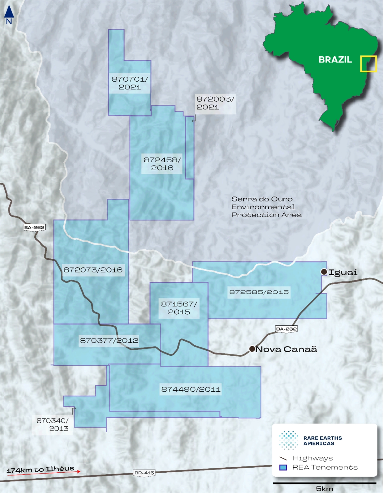
Note: Figure prepared by Rare Earths Americas, 2025.
Date: 31 October 2025 |
|
Page 3-7 |
|
|
|
Alpha Project Bahia, Brazil Technical Report Summary |
Although a number of concessions were originally granted for iron ore or granite, the company has submitted formal notices to ANM seeking amendment of these titles to cover rare earth elements.
Where titles have reached the end of their original exploration term, renewals have been lodged on time. Where titles have reached the Final Exploration Report Due Date, reports have been lodged on time. Accordingly, all rare earth results reported herein are associated with active tenure and remain in compliance with Brazilian mining regulations.
In addition to the titles listed in Table 3‑1, Rare Earth Americas holds title to 27 concessions in non-contiguous blocks distributed across the broader region. Collectively, these concessions cover 386 km² and to date have not been the subject of significant mineral exploration work. No formal assessment of their exploration potential has been made, and they are not included in the Project area that is the subject of this Report.
3.5 Surface Rights
To the Report date Rare Earth Americas has secured verbal agreements and signed consent declarations from landowners that allow for exploration and drilling activities at the Alpha Project. However, the company does not currently hold formal surface access agreements for activities beyond exploration and drilling. Negotiations for such agreements have not yet commenced. Rare Earth Americas intends to initiate formal discussions regarding broader surface rights as the Project progresses.
All concessions have sufficient area to accommodate mining activities. In addition, there is sufficient space within the existing concessions, outside the defined mineral resource area, to host the infrastructure required for a potential processing operation at the Project.
At this stage, any additional land required outside the current tenement package is expected to be limited in extent and could be purchased or leased within the local district. The area surrounding the Alpha Project is largely rural, comprising privately-held pastoral and agricultural land, and land availability is not currently considered by Rare Earths Americas to be a constraint.
3.6 Water Rights
Rare Earth Americas has not obtained any permits or agreements to extract water for exploration at the Alpha Project. Exploration to the Report date has not required water use. Future diamond core drilling may require water, which is expected to be commercially supplied via tankers or obtained under agreement for temporary extraction from local sources.
Any future mining and processing operations will require a dedicated water supply, expected to be sourced through commercial supply from nearby storage facilities and/or through permitted surface or groundwater extraction.
Date: 31 October 2025 |
|
Page 3-8 |
|
|
|
Alpha Project Bahia, Brazil Technical Report Summary |
3.7 Royalties
The Project is not subject to any private royalties. It is subject to the CFEM (see Chapter 3.2.4.)
3.8 Encumbrances
Rare Earth Americas have advised McGarry Geoconsulting Corp that it is not aware of any restrictions, liabilities, or claims affecting the Alpha Project mineral titles. To the company’s knowledge, there are no known environmental protections, community access rights, infrastructure easements, or other encumbrances that would materially impact exploration or potential development activities.
Portions of the Alpha Project lie within the Serra do Ouro Environmental Protection Area, a sustainable use conservation unit. While designation does not constitute a title encumbrance and mining within such areas is not prohibited, activities in such areas are subject to additional environmental licensing and permitting requirements, as discussed in Sections 3.9.
3.9 Environmental Considerations
Current activities at the Project are limited to mineral exploration. In the state of Bahia, the Instituto do Meio Ambiente e Recursos Hídricos (INEMA) is the designated authority responsible for monitoring environmental compliance, including the rehabilitation of drill pads and other surface disturbances resulting from exploration activities.
All exploration work undertaken to date, including auger drill pad construction and access road development, has been conducted in accordance with applicable state and local environmental regulations.
Rare Earth Americas acknowledges that any future advancement beyond the exploration stage will be subject to additional environmental permitting at both the state and federal levels. This will include requirements for environmental impact assessments, stakeholder engagement, and site rehabilitation plans.
Project concessions 870701/2021, 872458/2016, and 872003/2021, which host the Rio Preto deposit, lie within the Serra do Ouro Environmental Protection Area. Concessions 872073/2016 and 872585/2015, which include the Sapacaia and Rio das Pombas deposits, are partially covered by the Serra do Ouro Environmental Protection Area.
According to Federal Law 9.985/2000, an environmental protection area is classified as a form of conservation unit for sustainable use (Article 14, Item I), with the objective of making nature conservation compatible with the sustainable use of part of its natural resources (Article 7, Paragraph 2). In general, the law does not impose prohibitions on the development of potentially or effectively polluting activities, such as mining. However, it is required that any rules imposed in the Management Plan of the conservation unit be observed and that, within the scope of environmental licensing, there is coordination with the management body of the conservation unit.
Date: 31 October 2025 |
|
Page 3-9 |
|
|
|
Alpha Project Bahia, Brazil Technical Report Summary |
In the Brazilian legal framework, mining activities within sustainable use areas are not explicitly prohibited at the federal, state, or municipal levels. Activities in these areas must reconcile economic development with environmental preservation. Mining operations impacting these areas require licensing approval from the respective zone's management authority. This Authorization is contingent upon conducting thorough Environmental Impact Assessment (EIA) studies.
To the extent known to McGarry Geoconsulting, there are no environmental liabilities on the Project.
3.9.1 Baseline Studies
No formal environmental baseline studies have been conducted on the Project to the Report date. As at Report date, there are no known material environmental liabilities associated with the Project.
3.10 Permitting Considerations
3.10.1 Permitting Requirements
The Project is currently in the exploration stage. All exploration activities to date have been conducted in accordance with applicable federal and state regulations. The Project is located in the state of Bahia, Brazil, and is subject to oversight by both ANM, the federal mining authority, and INEMA, which is responsible for environmental permitting at the state level.
Next Permitting Milestones
The next permit milestones will include:
Acceptance of the Final Exploration Report marks the formal conclusion of the exploration phase. Once accepted, ANM may authorize the initiation of the mining concession application process. Authorization remains pending for all concessions.
Date: 31 October 2025 |
|
Page 3-10 |
|
|
|
Alpha Project Bahia, Brazil Technical Report Summary |
Future Permitting Milestones
Following acceptance of the Final Exploration Reports, Rare Earth Americas will prepare and submit an Economic Development Plan (Plano de Aproveitamento Econômico). The Economic Development Plan, which will be supported by a scoping study, must demonstrate the technical and economic viability of the proposed mining operation. Approval of the Economic Development Plan by ANM is required prior to issuance of any mining concession.
In parallel with the ANM process, Rare Earth Americas will initiate the environmental licensing process with INEMA. This process typically consists of three stages:
Each license is granted following the submission and review of the required EIA and supporting documentation.
3.10.2 Permitting Timelines
For the three concessions with granted Exploration Permits, Rare Earth Americas is undertaking the work necessary to support the preparation of Final Exploration Reports which are due between 2026 and 2027. For one of these concessions a substance change notice will be submitted with the Final Exploration Report, which is due in 2026.
For the six concessions with Final Exploration Reports and substance change notices submitted, the review and authorization process timeline is determined by ANM. Reviews are expected to be completed within a statutory period of six months; however, this timeframe is often exceeded, and COVID-19 impacts have further extended processing times. While Rare Earth Americas may formally request prioritization, the sequencing of reviews remains at ANM’s discretion.
All permitting efforts will be aligned with the advancement of the Project toward more detailed studies.
3.10.3 Permit Conditions
For all permits the applicant must be legally established in Brazil and in good standing with the relevant authorization authorities.
Date: 31 October 2025 |
|
Page 3-11 |
|
|
|
Alpha Project Bahia, Brazil Technical Report Summary |
3.10.4 Violations and Fines
There are no current material violations or fines as understood in the United States mining regulatory context that apply to the Project.
3.11 Social Considerations
Rare Earth Americas have not consulted with local communities during the exploration campaigns. The company’s interactions were limited to rural landowners, solely for the purpose of facilitating access for exploration activities.
Date: 31 October 2025 |
|
Page 3-12 |
|
|
|
Alpha Project Bahia, Brazil Technical Report Summary |
In 2023, Rare Earth Americas became members of the Management Council of the Serra do Ouro Environmental Protection Area. This conservation area is located in the municipality of Iguaí, and Project concessions 870701/2021, 872458/2016, 872003/2021 which host the Rio Preto deposit, are situated within its boundaries. Project concessions 872073/2016 and 872585/2015 which host the Sapacaia and Rio das Pombas deposits are partially covered by the Serra do Ouro Environmental Protection Area. As members, Rare Earth Americas are able to participate in council meetings.
3.12 Significant Factors and Risks That May Affect Access, Title, or Work Programs
To the extent known to McGarry Geoconsulting, there are no other significant factors and risks that may affect access, title, or the right or ability to perform work on the Project that are not discussed in this Report.
Date: 31 October 2025 |
|
Page 3-13 |
|
|
|
Alpha Project Bahia, Brazil Technical Report Summary |
4.0 ACCESSIBILITY, CLIMATE, LOCAL RESOURCES, INFRASTRUCTURE AND PHYSIOGRAPHY
4.1 Physiography
The Project is situated in a topographic region known as the "Plateaus and Mountain Ranges of the East and Southeast Atlantic" (Ross, 1985). This region includes the eastern portion of Bahia State and encompasses a wide strip of land characterized by crystalline bedrock, forming a north-south running plateau approximately 100 km inland from the coast.
4.1.1 Topography and Elevation
The topography of the region is characterized by the following dominant features:
The elevation difference between the plateau tops and valley floors is up to 400 m but typically ranges from 100–200 m. Elevation and relief should be considered in planning ground exploration and drill access. Measures such as drill pad and access preparation, or man-portable modular drill rigs, may be required. However, terrain conditions are not expected to materially constrain exploration at the Project.
4.1.2 Vegetation
Within the Project region, land is primarily used for cattle grazing, subsistence farming, and plantations. Upland plateaus often support denser primary vegetation. The Project lies within the Bahia Coastal Forests ecoregion (da Silva, 2018), which is characterized by primary Atlantic Forest (Mata Atlântica) with ombrophylous (thriving in heavy rainfall areas) tree cover (IBGE, 1993).
Project concessions 870701/2021, 872458/2016, and 872003/2021, which host the Rio Preto deposit, lie within the Serra do Ouro Environmental Protection Area. Concessions 872073/2016 and 872585/2015, which include the Sapacaia and Rio das Pombas deposits, are partially covered by the same conservation unit. The Serra do Ouro Environmental Protection Area was established because of
Date: 31 October 2025 |
|
Page 4-1 |
|
|
|
Alpha Project Bahia, Brazil Technical Report Summary |
the natural characteristics of the area covered, such as the remnants of the Atlantic Forest biome, especially fragments of semi-deciduous seasonal forest of ecological importance.
Remnants of native vegetation are primarily confined to steep-sided valleys and hillsides hitherto unsuitable for cattle grazing or other agricultural use. On the Rare Earth Americas concessions, these occur primarily along the valleys of the Rio Preto, Sapacaia, and Rio das Pombas deposits, with a significant forested area northwest of Nova Canaã in the Rio das Pombas area.
The presence of protected vegetation zones may limit access for exploration activities, require modified drilling methods, and influence mining of and the placement infrastructure to minimize environmental impacts and permitting requirements.
4.2 Accessibility
All Rare Earth Americas concessions are within approximately 35 km of Brazil's major federal highway BR-116 to the west and 80 km of BR-101 to the east. These highways provide direct access to the country's key infrastructure and industrial centers. The concessions can be easily reached from either highway, first by paved highway BA-262 which passes through the Sapacaia, Nova Canaã and Rio das Pombas deposits; and then by a network of partially paved and unpaved roads. All deposit areas are within 1–2 km of municipal road networks. Exploration sites within the concession areas can be accessed using off-road vehicles via existing agricultural tracks or tracks established by Rare Earth Americas through open pasture, plantations, or forests.
4.3 Climate
The climate in the Project area is tropical savanna, classified as 'Aw' under the Köppen climate classification system.
The average annual temperature is about 22.3°C. The highest average temperatures are observed in March, reaching around 23.9°C. July is the coldest month, with temperatures averaging 20.2°C.
The annual precipitation in the area averages 633 mm. Rainfall is irregularly distributed, with most of the rain occurring from October–April.
4.3.1 Length of Operating Season
Field exploration operations can be conducted throughout the year except for short periods of intense rainfall during the summer season, which may diminish drilling capabilities.
Mining operations in the region, supported by the necessary infrastructure, operate year-round. It is expected that any future mining activity in the Project area would be year-round.
Date: 31 October 2025 |
|
Page 4-2 |
|
|
|
Alpha Project Bahia, Brazil Technical Report Summary |
4.4 Infrastructure
The Project area is located approximately 270 km southwest of Salvador, the capital of Bahia State in Northeast Brazil.
The Project is surrounded by small population centers that are classified as cities and towns. The closest municipality to the Project center, Iguaí, has a population of approximately 27,000 and offers various amenities to support mineral exploration, including: food, accommodation, fuel, automotive services, and medical facilities. Within the Project area, there are several small settlements. The region's land use comprises primarily cattle grazing, subsistence farming, plantations (coffee, cocoa, cereals, and cassava), and tourism.
The Project is <500 km by road from Camaçari petrochemical complex that produces ammonium sulphate and sulfuric acid, which are key reagents required for any process plant treating the mineralization within the Project area.
The Port of Ilhéus, located about 120 km from the Project, can be accessed via highway BR-415 and could be used for the transportation of freight, heavy machinery, consumables, and mineral products associated with mining.
4.4.1 Water
The concessions are crossed by three perennial rivers: Rio Preto, Rio do Vigário and the Rio das Pombas. The Project is situated on a hard-rock aquifer with low productivity (CPRM, 2010) that is not considered to be sensitive to mining extraction.
Piped water supplied by the state utility company can be accessed in the municipalities of Iguaí and Nova Canaã along highway BA-262, which passes through the permit area.
4.4.2 Electricity and Power
A 500 kV electrical transmission line passes 30 km to the east of the Project and could be used to connect the Project to low-cost hydroelectric power generated at the Pedra do Cavalo station (162 MW) located 140 km to the northeast. A natural gas pipeline runs 80 km to the east of the Project, parallel to the Project area.
4.4.3 Personnel
All of the current manual labor requirements for the Project, which consist of exploration activities, are met by personnel from nearby communities.
Recruitment from outside the area may be required to secure experienced and competent senior personnel for mining operations.
Date: 31 October 2025 |
|
Page 4-3 |
|
|
|
Alpha Project Bahia, Brazil Technical Report Summary |
4.4.4 Supplies
Salvador has a population of approximately three million and provides access to equipment, supplies, and manpower required for mining operations. The city is served by the Salvador Bahia International Airport. Additionally, the Project can be connected to transcontinental road and rail networks, as well as international maritime links.
Date: 31 October 2025 |
|
Page 4-4 |
|
|
|
Alpha Project Bahia, Brazil Technical Report Summary |
5.0 HISTORY
There is no known previous exploration for rare earth elements in the Project area prior to Rare Earths Americas’ interest in the Project.
A regional-scale airborne geophysical survey was commissioned in 2006 by the Companhia Baiana de Pesquisa Mineral (CBPM), a state mineral research agency. The 18,000 km2 high-resolution airborne magnetic and radiometric survey was completed at 500 m line spacings and covered the east and south of the Jequié Block. The survey identified a provincial-scale corridor of radiometric anomalies related to the Volta do Rio Plutonic Suite. This historical dataset was acquired by Rare Earth Americas.
In 2021, Alpha Minerals Brazil Participações Ltd, a wholly owned subsidiary of Rare Earth Americas, conducted a review of the CBPM regional-scale airborne geophysical surveys. Based on the presence of prospective anomalies associated with the Volta do Rio Plutonic Suite, exploration licenses were acquired by Alpha Minerals Brazil Participações Ltd, between 2021 and 2023.
Rare Earth Americas was created as the holding company for the Project in January 2023 with Alpha Minerals Brazil Participações Ltd, becoming a wholly owned subsidiary of Rare Earth Americas.
Date: 31 October 2025 |
|
Page 5-1 |
|
|
|
Alpha Project Bahia, Brazil Technical Report Summary |
6.0 GEOLOGICAL SETTING, MINERALIZATION, AND DEPOSIT
6.1 Deposit Type
The Project hosts rare earth element mineralization in the form of ionically adsorbed rare earth elements bound to clay minerals within the regolith developed over the crystalline basement. Although ionic adsorption clay deposits are not currently classified within the United States Geological Survey Mineral Deposit Model series, the deposit type is well defined in the geological literature.
Residual deposits of rare-earth element-bearing clays are termed ion-adsorption clays. These deposits associated are typically associated with weathered rare-earth element-enriched granites. Rare-earth elements released during the weathering of the granites and the breakdown of primary minerals are adsorbed by kaolin and other clay minerals such as halloysite.
During weathering, water and other agents break down the rock and minerals releasing rare-earth elements as trivalent ions into solution. These fluids then migrate downwards through the regolith and rare-earth element ions may become adsorbed within the interlayer spaces of clay minerals, such as kaolinite, halloysite, smectite or illite. The Project has areas that are prospective for such clay hosted rare-earth element mineralization and some of the tested clays display an ionic character.
The weathered, rare-earth element-rich zones typically range from 3–10 m thick, and can be divided into four layers based on mineralogy:
The bedrock source of rare earth elements at the Project are granite gneisses enriched in thorium, uranium, and rare earth elements.
6.2 Regional Geology
The Project area is underlain by crystalline basement comprised of granites, gneisses, granulites and migmatites of Archean to Paleoproterozoic age, which are part of a major tectonic domain known as the São Francisco Craton (Heilbron et al. 2017).
The Project sits within the Jequié Block, a tectono-structural block of the northeastern São Francisco Craton that contains an assemblage of granitic intrusions and supracrustal rocks that have been metamorphosed to granulite facies (Fernandes et al., 2019).
Date: 31 October 2025 |
|
Page 6-1 |
|
|
|
Alpha Project Bahia, Brazil Technical Report Summary |
The Jequié Complex is located between the Gavião Block to the west and the Serrinha Block to the east (Figure 6‑1).
Figure 6‑1: Regional Geology Plan
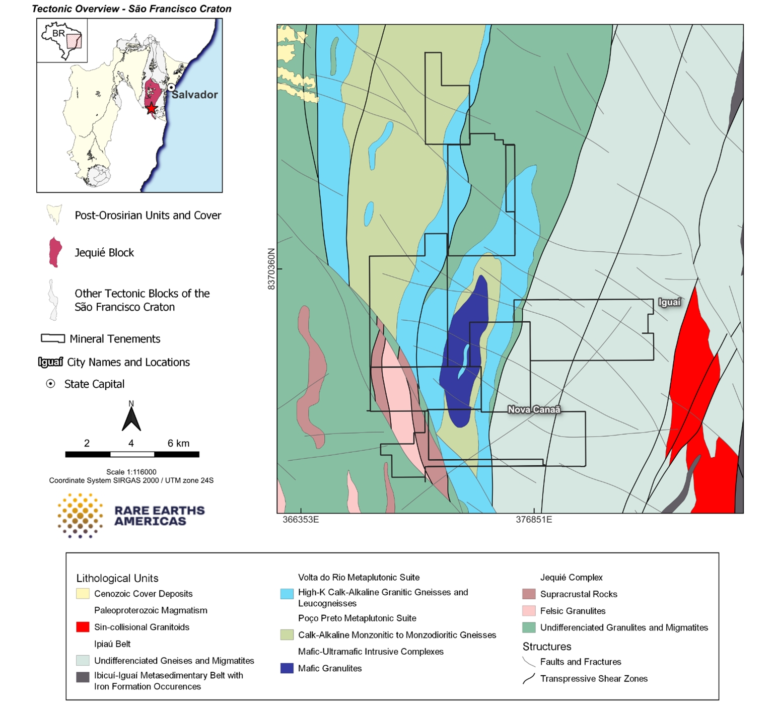
Note: Figure prepared by Rare Earths Americas, 2025.
Several tectonic cycles affected the Region, most significantly the Transamazonic Cycle at approximately 2.0 billion years ago which is responsible for the collision between the Jequié Block and the Serrinha block to the east. Their suture zone is marked by the Ipiaú Belt, a corridor of gneisses with intercalated amphibolite, quartz-feldspathic rocks, and granites.
Date: 31 October 2025 |
|
Page 6-2 |
|
|
|
Alpha Project Bahia, Brazil Technical Report Summary |
6.3 Local Geology
The core of the Jequié Complex consists of undifferentiated granulites, migmatites, and supracrustal rocks. Contacts between these units are marked by regional-scale thrusts, shear zones, and younger felsic metaplutonic intrusions. These lithologies are most prominently exposed southwest of the Project, within the Nova Canaã deposit area.
At approximately 2.6 Ga, the Jequié Complex was intruded by the Volta do Rio and Poço Preto Plutonic Suites. These suites form large, north–northeast–south–southwest-trending batholiths that extend through the Project area and continue both to the north and south.
6.3.1 Volta do Rio Suite
The Volta do Rio Suite, consists of high-potassium, slightly peraluminous, calcium-alkaline orthogneisses enriched in thorium, uranium and rare earth elements, which generate a pronounced gamma-spectrometric signature, easily distinguishable on regional aero geophysical maps, and characterizes it as a major source of the ionic clay-type mineralization found in the regolith in the area. The Volta do Rio Suite extends over a distance of 200 km (Fernandes et al., 2019) and reaches widths of up to 20 km (refer to Figure 6‑1).
Significant units of the Volta do Rio Suite include:
These units may be associated with occurrences of secondary monazite and +1% TREO grades in the Project area.
6.4 Structure
A complex structural history is evident in the rocks in the Project area. Units of the Jequié block record multiple episodes of ductile deformation contemporaneous with the Transamazonic Cycle collision and associated high-grade metamorphism (Barbosa et al., 2004).
Date: 31 October 2025 |
|
Page 6-3 |
|
|
|
Alpha Project Bahia, Brazil Technical Report Summary |
During Paleoproterozoic collision, large westward thrusts stacked rocks of the Ipiaú Belt and Serrinha Block on top of those in the Jequié Block. This deformation phase is associated with large isoclinal F1 folds with inclined axial planes that trend north-northeast and dip steeply to the west, these are affected by subsequent orthogonal F2 folds with axial planes striking east–southeast. The resulting fold interference pattern that controls the distribution of the prospective rocks of the Volta do Rio Suite.
With continued deformation, thrusts became sinistral transcurrent shear zones characterized by vertical foliation with sub horizontal lineation. As a result, the region is intensely affected by northeast–southwest-trending shear zones that bound, and may penetrate, major lithostratigraphic units including the Volta do Rio Suite.
Conjugate sets of later north–northwest- and west–northwest-oriented brittle fault structures cross-cut geological units at the Project. Faults are represented by fractures and tectonic brecciation with bedrock offsets at the deposit scale ranging from tens to hundreds of meters, and at the regional scale of many kilometers along the Rio do Vigario shear zone which truncates the Volta do Rio and Poço Preto Plutonic Suites and Ipiaú Belt to the south.
6.5 Regolith Profile
The weathering profile can be divided into a rare earth element-leached zone in the upper part of the profile and a rare earth element accumulation zone with more ion-exchangeable rare earth elements in the lower part of the profile. Laterite horizons are absent within the Project area.
Rare Earths Americas used a weathering intensity proxy for the identification of ionically adsorbed to clay rare earth element enrichment within the Project area. This is defined geochemically using the “chemical index of alteration” developed by Goldberg and Humayun (2010) and Nesbit and Young (1982). The chemical index of alteration is a recognized measure for chemical weathering during the production of clastic sediments, being the degradation of feldspars and the formation of clay minerals during weathering.
The chemical index of alteration is denoted with the following ratio:
The weathering profile in the Project area is summarized by stratigraphic unit in Table 6‑1. An example cross-section is provided as Figure 6‑2.
Bedrock exposure at the Project is limited to occasional outcrops at erosional scarps and along drainage channels. Due to poor exposure, mapping and effective remote sensing of bedrock at the deposit scale can be challenging.
Date: 31 October 2025 |
|
Page 6-4 |
|
|
|
Alpha Project Bahia, Brazil Technical Report Summary |
Table 6‑1: Stratigraphic Column Through Weathering Profile
Profile Element |
Note |
Mottled zone |
CIA >95% indicates an extremely weathered mottled zone, averaging a depth of 5.5 m. Here, REE-bearing minerals dissolve in acidic soil water, transporting REEs downward as aqueous complexes or REE3+, creating a REE-leached zone with low REE grades |
Saprolite |
CIA 65–95%, which has been drilled to an average depth of 14 m but typically extends to an average depth of 25 m in sonic drilling. In this zone, REE-bearing fluids mix with less acidic groundwater, causing REEs to become immobilized by adsorption to ionic clay or incorporation into secondary minerals |
Saprolite accumulation zone |
Heavy rare earth oxide enrichment with depth. |
Saprock |
CIA 50–65% indicates saprock. The base of the saprock has not been tested, so its thickness is unknown |
Fresh rock |
CIA <50% indicates fresh rock |
Note: CIA = chemical index of alteration; REE = rare earth element(s).
Date: 31 October 2025 |
|
Page 6-5 |
|
|
|
Alpha Project Bahia, Brazil Technical Report Summary |
Figure 6‑2: Example Strip Log Stratigraphy, Drill Hole ST10944 (left) and Schematic Ionic Adsorption Clay Model (right)
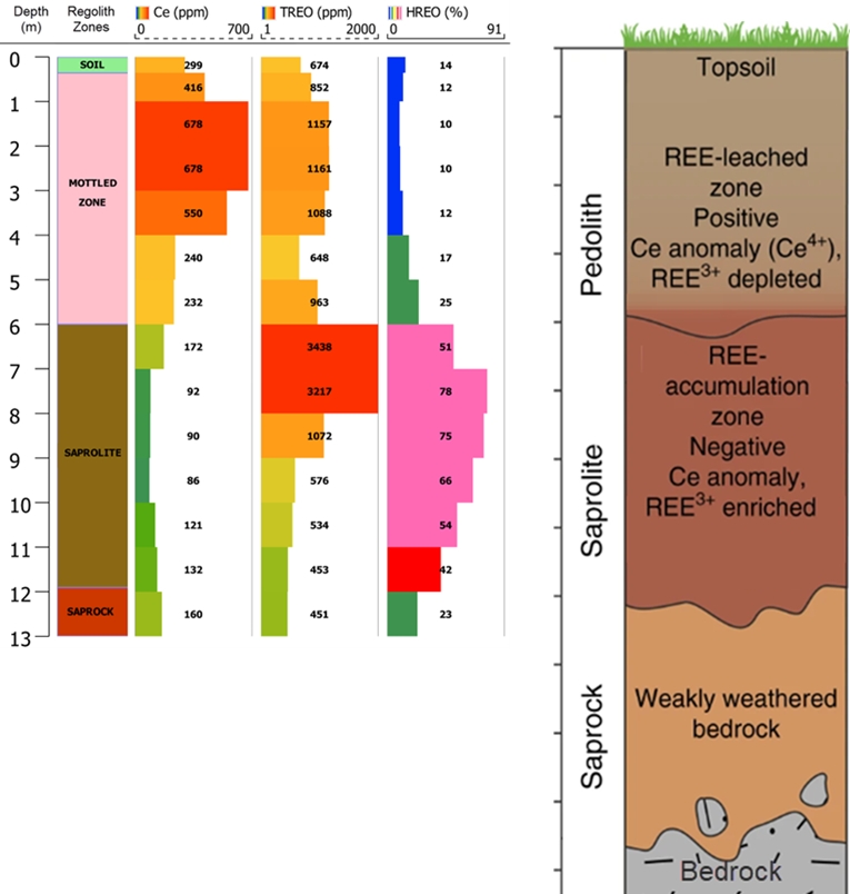
Note: Figure prepared by Rare Earths Americas, 2024.
6.6 Deposit Descriptions
6.6.1 Rio Preto Deposit
Deposit Dimensions
The Rio Preto deposit extends approximately 5,500 m north–south and 3,000 m east–west and has a surface area of 14 km². The average depth of the deposit is approximately 23 m.
Date: 31 October 2025 |
|
Page 6-6 |
|
|
|
Alpha Project Bahia, Brazil Technical Report Summary |
Bedrock Geology
The core of the deposit consists of granulites and migmatites of the Jequié Complex. Along the western and southeastern margins of the deposit, the Volta do Rio Plutonic Suite are repeated on the limbs of a regional fold. These units represent the main protolith and occupy the majority of the deposit area. A cross-section through the deposit is shown in Figure 6-3.
Figure 6‑3: Example Geological Cross Section Rio Preto
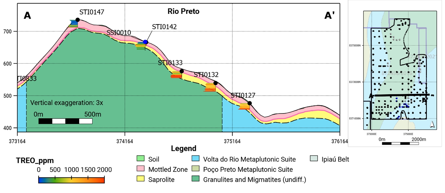
Note: Figure prepared by McGarry Geoconsulting, 2025. Figure shows modelled regolith units and interpreted bedrock geology with drill samples colored by total rare earth oxide grade. TREO = total rare earth oxide.
Regolith and Weathering
The weathering profile includes soil, mottled zone, and saprolite horizons.
Soil thickness ranges from 0.3–to 6.8 m, averaging 0.9 m.
The mottled zone is well developed at higher elevations and thinner at valley bottoms. Typical thicknesses range between 7–13 m with an average of 11 m.
Saprolite is of variable thickness and has been intersected to depths of up to 49 m below surface on the s portion. It occurs at an average depth of 2.83 m, with typical thicknesses between 9–17 m, and the thickest intervals intersected along the slopes to the south of the River Preto.
Mineralization
Ionic clay mineralization is encountered throughout the Rio Preto deposit, with significant rare earth grades exceeding 1,000 ppm total rare earth oxide (TREO) observed across the deposit. The
Date: 31 October 2025 |
|
Page 6-7 |
|
|
|
Alpha Project Bahia, Brazil Technical Report Summary |
highest-grade rare earth concentrations occur in the western and southeastern portions of the deposit, in proximity to the Volta do Rio Suite. In most areas, the regolith exhibits an ionic clay rare earth profile with leached upper horizons transitioning downward into a discontinuous rare earth accumulation zone, variably exposed by erosion and characterized by neodymium–praseodymium (NdPr):TREO ratios >20%.
In the highland plateaus, at elevations above 600 masl, the regolith profile comprises a thick, low-grade mottled zone overburden underlain by deeper saprolite horizons that remain poorly tested by auger drilling.
The slope zone, situated between the highland plateaus and lower pediment zones, is subject to higher rates of erosion and overburden removal. Consequently, the slope zone is considered more prospective for occurrences of thick rare earth element-mineralized saprolite at or near surface.
The rare earth profile remains only partially tested by auger drilling, with most holes terminating in mineralization. This relationship is illustrated in the example cross-section through the mineralization that was presented in Figure 6-3.
6.6.2 Sapacaia Deposit
Deposit Dimensions
The Sapacaia deposit has a defined north–south extent of approximately 6,000 m and an east–west extent of 1,900 m, covering a surface area of 12.1 km². The average depth of the deposit is approximately 24 m.
Bedrock Geology
The deposit is predominantly underlain by the Volta Do Rio Suite which is repeated on the limbs of a regional north–northeast-oriented fold which closes at the southern end of the deposit which reached a width of 2.5 km. The Volta do Rio Suite represents the main protolith of the regolith deposit. The core of the fold is occupied by granulites of the Jequié Complex forming a wedge shape. No significant structural features or fault systems have been mapped within the Sapacaia deposit area. A cross-section through the deposit is shown in Figure 6‑4.
Date: 31 October 2025 |
|
Page 6-8 |
|
|
|
Alpha Project Bahia, Brazil Technical Report Summary |
Figure 6‑4: Example Geological Cross-Section Sapacaia
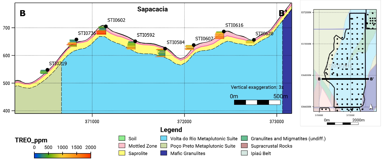
Note: Figure prepared by McGarry Geoconsulting, 2025. Figure shows modelled regolith units and interpreted bedrock geology with drill samples colored by total rare earth oxide grade.
Regolith and Weathering
The regolith profile at Sapacaia is well preserved, exhibiting a complete and laterally extensive weathering sequence that includes soil, mottled zone, and saprolite horizons. The soil horizon is thin an average thickness of 1.1 m. It is discontinuously distributed across the property. The mottled zone is well developed across the entire deposit area and is typically 4–8 m thick, with an average of 6 m. It is locally shallower in areas of surface erosion and drainage concentration. The saprolite horizon is the most extensive weathered unit and hosts the majority of the rare earth mineralization. It occurs at an average depth of 7.3 m below surface, with typical thicknesses ranging from 14–21 m. The average modelled thickness is 13 m, and the maximum thickness is 40 m.
Mineralization
Rare earth mineralization is encountered throughout the Sapacaia deposit area. The highest-grade rare earth concentrations occur along the north–south trend of the folded Volta do Rio Suite protolith. Regolith mineralization is bounded by the occurrence of barren ultramafic rocks to the east and barren rocks of the Poço Preto Suite to the west.
The regolith exhibits an intermittent ionic clay rare earth profile, with enriched zones characterized by high NdPr:TREO ratios of 20% or more, indicative of remobilized rare earths in ionic clay horizons. These enriched zones are typically restricted to well-developed saprolite preserved on gentle hills as shown in the example cross-section in Figure 6‑4.
Date: 31 October 2025 |
|
Page 6-9 |
|
|
|
Alpha Project Bahia, Brazil Technical Report Summary |
At elevations below 650 masl, the terrain is characterized by valleys and terraces with occasional bedrock exposures. In these areas, preservation of mineralized regolith is reduced due to erosion.
Within the Sapacaia deposit, auger drilling used to estimate the mineral resource intersected zones with rare earth oxide concentrations exceeding 1% TREO, accompanied by low leaching recoveries, along a north-south trend. An example is auger hole STI0731 (Figure 6‑5) which contains a 3 m averaging 2.8% TREO from 10 m to 13 m, within a broader 9.8m interval averaging 1% TREO. These grades exceed the enrichment possible through ionic adsorption rare earth element to clay, and therefore the presence of rare earth minerals in regolith may reflect an underlying primary mineralization source within the magmatic bedrock stratigraphy of the Volta do Rio Plutonic Suite.
Figure 6‑5: Sapacaia Secondary REE Mineral Zone Geological Cross-Section
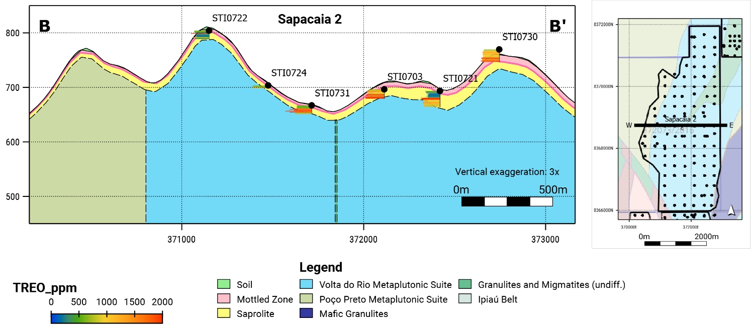
Note: Figure prepared by McGarry Geoconsulting, 2025. Figure shows modelled regolith units and interpreted bedrock geology with drill samples colored by total rare earth oxide grade.
6.6.3 Nova Canaã Deposit
Deposit Dimensions
The Nova Canaã deposit extends approximately 2,400 m north–south and 2,340 m east–west, with a surface area of 3.8 km². The average depth of the deposit is approximately 25 m.
Bedrock Geology
The deposit is centered on a north–northwest-oriented belt of the Volta do Rio Suite. To the west, felsic granulites of the Jequié Complex occur within a fault bound block over a 6 km strike length that is partially covered by Rare Earths Americas’ concessions. These units are the main protolith and occupy most of
Date: 31 October 2025 |
|
Page 6-10 |
|
|
|
Alpha Project Bahia, Brazil Technical Report Summary |
the deposit area. No mapped structures have been identified in the area. A cross-section through the deposit is shown in Figure 6‑6.
Figure 6‑6: Example Geological Cross-Section Nova Canaã
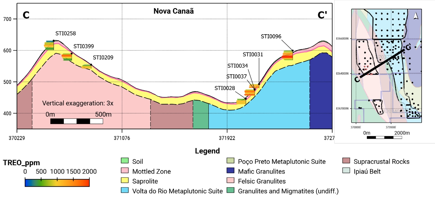
Note: Figure prepared by McGarry Geoconsulting, 2025. Figure shows modelled regolith units and interpreted bedrock geology with drill samples colored by total rare earth oxide grade.
Regolith and Weathering
The regolith profile is well preserved, exhibiting a complete and laterally extensive weathering sequence that includes soil, mottled zone, and saprolite horizons.
The soil horizon is thin with an average thickness of 1 m.
The leached mottled zone is well developed across the entire deposit area, and is typically 4–8 m thick, with an average of 6 m. It is thickest along the ridge of felsic granulites at the west of the property and shallower in areas of surface erosion and drainage concentration.
The saprolite horizon is the most extensive weathered unit and hosts the majority of the rare earth mineralization. It occurs at an average depth of 7 m below surface, with typical thicknesses ranging from 16–22 m. The average modelled thickness is 18 m, and the maximum thickness is 42 m.
Mineralization
Rare earth mineralization is encountered throughout the Nova Canaã deposit. The highest-grade rare earth concentrations occur along the VRPS belt and overlying the felsic granulites of the Jequié Complex.
Date: 31 October 2025 |
|
Page 6-11 |
|
|
|
Alpha Project Bahia, Brazil Technical Report Summary |
The regolith overlying the Volta do Rio Suite exhibits a discontinuous ionic clay rare earth profile with grades above 1,000 ppm TREO over intervals of 5–20 m. At elevations below 650 masl, preservation of mineralized regolith is reduced due to erosion associated with the valleys and terraces of the Rio do Vigario, which occupies a northwest orientated regional shear zone.
To the west of this shear zone, the felsic granulites of the Jequié Complex form a topographic high with a well-developed ionic clay rare earth profile. A broad enriched zone spanning 1.5 km north–south and 300 m east–west is characterized by high NdPr:TREO ratios of 20% or more and grades >1,000 ppm TREO occurring over thickness of 10–20 m.
Within the Nova Canaã deposit, regolith has been found to contain significant rare earth mineralization, exemplified by a surface sample at the southern end of the deposit which returned a grade of 1.62% TREO (see discussion in Chapter 7). These rare earth grades exceed the enrichment possible in ionic clay deposits and are attributable to rare earth minerals, such as monazite, in the regolith, and may reflect an underlying bedrock mineralization source.
6.6.4 Rio das Pombas Deposit
Deposit Dimensions
The Rio das Pombas deposit extends approximately 2,400 m north–south and 2,340 m east–west, with a surface area of 3.8 km². The average depth of the deposit is approximately 25 m.
Bedrock Geology
The deposit is underlain by rock of the Volta do Rio Suite, granulites of the of the Jequié Block and Ipiaú Belt. These rocks represent the main protolith of the rare earth element deposits. The sequence occurs along the eastern limb of a regional fold. The main deposit is orientated north–south along this limb, with eastward continuation of the deposit into the Ipiaú Belt. A long-section through the northern portion deposit is shown in Figure 6‑7, and the southern portion of the deposit in Figure 6‑8.
Date: 31 October 2025 |
|
Page 6-12 |
|
|
|
Alpha Project Bahia, Brazil Technical Report Summary |
Figure 6‑7: Example Geological Long-Section Rio das Pombas North
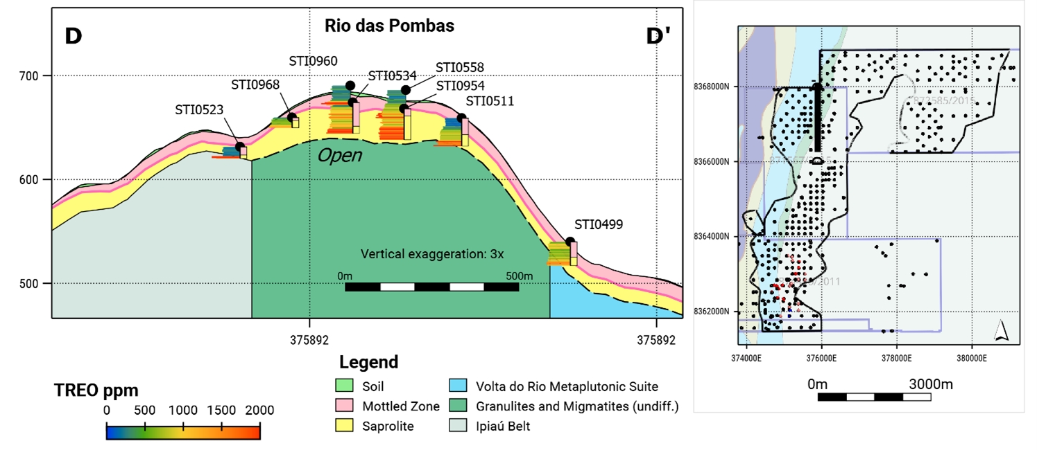
Note: Figure prepared by McGarry Geoconsulting, 2025. Figure shows modelled regolith units and interpreted bedrock geology with drill samples colored by total rare earth oxide grade.
Figure 6‑8: Example Geological Long-Section Rio das Pombas South
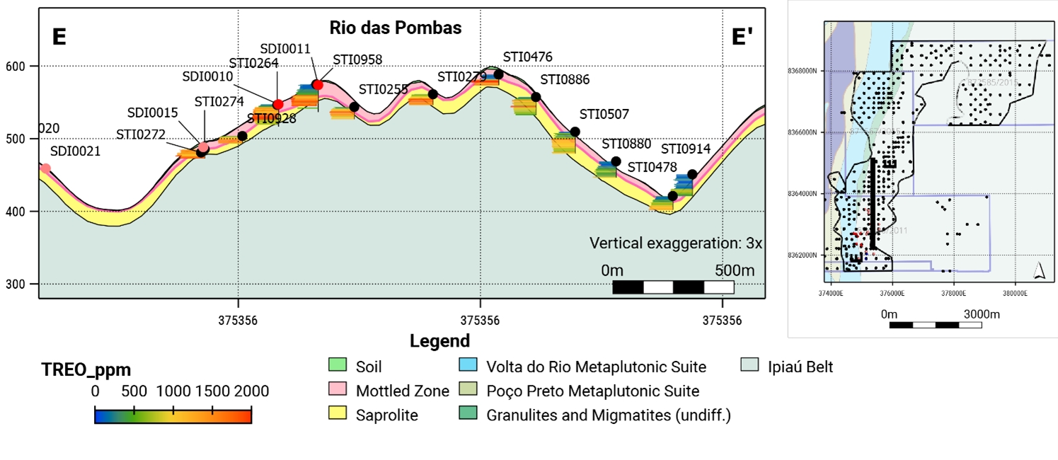
Note: Figure prepared by McGarry Geoconsulting, 2025. Figure shows modelled regolith units and interpreted bedrock geology with drill samples colored by total rare earth oxide grade.
Date: 31 October 2025 |
|
Page 6-13 |
|
|
|
Alpha Project Bahia, Brazil Technical Report Summary |
Regolith and Weathering
The weathering profile includes soil, mottled zone, and saprolite horizons. Soil thickness can be up to 5.3 m, averaging 1 m. The mottled zone is discontinuous, with typical thicknesses between 6–12 m and an average of 9 m. Saprolite is of variable thickness and has been intersected to depths up to 65 m below surface in the southwestern portion. It occurs at an average depth of 10 m, with thicknesses ranging from 14–24 m.
Mineralization
Well-developed ionic clay mineralization is encountered along a north–northeast-oriented plateau cantered on the resistive granulites and migmatites of the Jequié Block and the Ipiaú Belt to the east. Ionic clay mineralization with significant rare earth grades exceeding 2,000 ppm TREO was intersected by auger drilling at the break of slope along the east and west of this plateau along a strike length of 7 km.
The regolith exhibits a well-developed ionic clay rare earth profile with leached upper horizons to depths of 5–20 m, which transitions downward into a rare earth accumulation zone. The ionic clay rare earth profile overlies the granulites and migmatites of the Jequié Block as shown in Figure 6‑7 and Ipiaú Block as shown in Figure 6‑8.
The rare earth profile is only partially tested by auger drilling at the deposit, and most drill holes end in mineralization.
Date: 31 October 2025 |
|
Page 6-14 |
|
|
|
Alpha Project Bahia, Brazil Technical Report Summary |
7.0 EXPLORATION
7.1 Exploration
7.1.1 Grids and Surveys
Exploration grids used to position drill holes are orientated to the geographic projection system SIRGAS 2000 Universal Transverse Mercator zone 24 South.
The geological modelling used a topographic digital terrain model derived from radar interferometry data obtained from the Shuttle Radar Topography Mission (SRTM) during February 2000. The SRTM 1-arc second (~30 m) digital terrain model used in the Project area has a typical vertical accuracy of ±10 m (90% confidence) and a horizontal accuracy of approximately ±20 m. Relative to the topography, surveyed collar coordinates have an average absolute difference of 5 m ranging from ‑28 m–21 m. To account for these differences, drill collars were projected on to the digital terrain model surface.
It is recommended that collar locations be surveyed using a method with higher accuracy than the current hand-held methods, such as differential global positioning system (GPS) instrument survey. In addition, a higher resolution topography survey should be undertaken to generate a digital terrain model that aligns with projected collar positions surveyed by differential GPS. A more accurate survey that captures topographic features in greater detail would benefit any future engineering studies and bulk sample excavation designs.
7.1.2 Geological Mapping
The bedrock geology is largely concealed beneath a deep regolith and soil cover. Exposures of weathered protolith are rare and primarily restricted to anthropogenic and natural excavations, including road cuts and drainage channels. Geological investigations have concentrated on these limited outcrops to validate published regional geological maps.
7.1.3 Airborne Geophysics
In 2006, Companhia Baiana de Pesquisa Mineral commissioned an 18,000 km2 high-resolution regional-scale airborne magnetic and radiometric survey. The survey covered the east and south of the Jequié Block including what became the Alpha Project area.
The survey identified a provincial-scale corridor of radiometric anomalies related to the Volta do Rio Plutonic Suite. This corridor stretches over 200 km from north to south and has widths ranging from 10–20 km.
In 2023 Rare Earth Americas acquired the CBMP survey data, and reprocessed raw data to an enhanced resolution cell size of 125 m2. Radiometric thorium equivalent (eTh) anomalies guided exploration targeting on the basis that the eTh signature was associated with rare earth element-bearing minerals in the bedrock and areas that were prospective for ionic adsorption clay deposits.
Date: 31 October 2025 |
|
Page 7-1 |
|
|
|
Alpha Project Bahia, Brazil Technical Report Summary |
7.1.4 Geochemistry
During initial reconnaissance and prospecting in 2023, Rare Earth Americas collected 107 surface samples from limited regolith and bedrock exposures across its concessions for geochemical analysis.
Grab samples were collected from saprolite, saprock and float using a rock hammer to obtain representative fragments with an average weight of 1 kg. Rock fragments were placed in pre-numbered sample bags in the field and then transported to the company’s exploration facility prior to shipment to the laboratory. Grab samples were collected from individual point locations and do not represent continuous sampling along the mineralized system.
After collection in the field, grab samples were placed in sealed plastic bags that were then placed into larger polyweave bags labelled with the sample IDs inside and transported to the company’s secure warehouse.
Sample results are summarized in Table 7‑1 and shown in
Figure 7‑1, superimposed on the regional airborne survey within the Project area.
Table 7‑1: 2023 Summary of Surface Samples
Tenement |
Count |
TREO (ppm) |
||
Min |
Average |
Max |
||
Concessions Hosting Mineral Resources |
||||
872458/2016 |
24 |
106.9 |
946.5 |
3,684.4 |
872003/2021 |
1 |
243.9 |
243.9 |
243.9 |
872073/2016 |
9 |
86.2 |
1,737.2 |
5,962.7 |
870377/2012 |
14 |
84.2 |
350.1 |
975.4 |
874490/2011 |
29 |
27.4 |
987.3 |
16,194.1 |
870340/2013 |
7 |
94.2 |
284.3 |
822.6 |
871567/2015 |
7 |
247.4 |
528.0 |
1,178.8 |
872585/2015 |
6 |
21.8 |
188.7 |
402.4 |
Other Concessions |
||||
870701/2021 |
10 |
67.2 |
396.2 |
1,380.4 |
7.1.5 Qualified Person’s Interpretation of the Exploration Information
Exploration information obtained by Rare Earth Americas is predominantly derived from auger holes drilled on a regular grid across the exploration concessions. This method provides an efficient means of defining regolith horizons and identifying rare earth enrichment within the saprolite, which typically begins at depths of around 5 m in the Project area.
Date: 31 October 2025 |
|
Page 7-2 |
|
|
|
Alpha Project Bahia, Brazil Technical Report Summary |
Significant results from widely spaced auger drilling are subsequently followed up with tighter infill drill grids, enabling Rare Earth Americas to vector zones of higher rare earth enrichment. This technique has generated the majority of the data used to delineate and estimate the current mineral resources.
Auger drilling is limited in penetration, reaching a maximum of approximately 30 m, and commonly 10–15 m where refusal is encountered due to hard ground or groundwater. This depth constraint results in only partial characterization of the regolith profile and may leave deeper mineralized zones untested.
The exploration programs completed by Rare Earth Americas to the Report date are appropriate for the style of mineralization; however, alternative methods such as sonic or aircore drilling could provide more comprehensive regolith profiles and improve the assessment of deeper mineralization.
To the Report date surface grab sampling has not yet materially influenced targeting, though future follow-up may demonstrate correlations with broader mineralized zones and validate the method.
Date: 31 October 2025 |
|
Page 7-3 |
|
|
|
Alpha Project Bahia, Brazil Technical Report Summary |
Figure 7‑1: Surface Sample Location Map
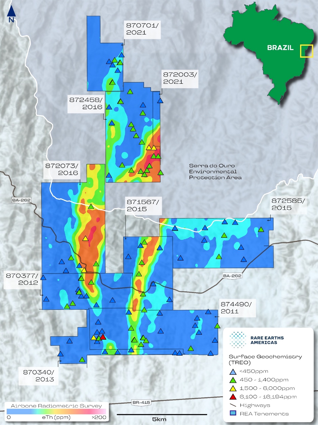
Note: Figure prepared by Rare Earths Americas, 2025. Map underlay from the regional airborne radiometric survey.
Date: 31 October 2025 |
|
Page 7-4 |
|
|
|
Alpha Project Bahia, Brazil Technical Report Summary |
7.1.6 Exploration Potential
Ionic Clay Mineralization
The extent of the mineral resource models is predominantly limited by the availability of exploration data and by tenement boundaries. Although individual rare earth element-bearing horizons may pinch out, many deposit areas are open at depth and also have potential for the delineation of well mineralized ionic adsorption clay zones, highly enriched in rare earth elements.
Auger holes have limited depth penetration and drill holes typically provide only a partial profile of mineralized saprolite at the project. As highlighted in auger holes, STI0132, STI0133 and STI0127 at Rio Preto (refer to Figure 6‑3, drill holes were used to estimate mineral resources) and auger holes STI0534, STI0954 at Rio das Pombas North (refer to Figure 6‑7, drill holes were used to estimate mineral resources), auger drilling commonly terminated in mineralization. There is potential to extend the mineralization model deeper with core drilling.
The most intense enrichment Ionic clay mineralization by mobilized rare earth elements occurs in slope zones and within the deep regolith mantle of hilltops. The close association between topography and ionic adsorption clay mineralization means there is potential to delineate higher-grade zones with targeted infill drilling by auger or core drilling methods at prospective terrain features.
Secondary Monazite in Regolith
Within the Sapacaia and Nova Canaã deposits, auger drilling used in the mineral resource estimate has encountered rare earth elements at particularly high concentrations with elevated phosphorus, thorium and uranium incompatible with ionic adsorption clay mineralization. Anomalous results from regolith samples obtained by auger and surface sampling are consistent with the presence of secondary regolith-hosted rare earth minerals such monazite.
In the extent of the current mineral resource model, rare earth oxide concentrations >1% and low leaching recovery, are encountered over a north–south corridor approximately 3.5 km long extending from STI0770 in the north to STI0031 in the south (Figure 7‑2). These results, presented in Table 7‑2, are indicative of secondary rare earth minerals that are not amenable to recovery through the proposed ionic absorbent clay processing route. Targeted infill drilling has the potential to refine the current deposit model by delineating a zone of rare earth mineral enrichment within the regolith, which could then be excluded from the ionic absorbent clay resource model and assessed for alternative processing methods.
These findings demonstrate potential for high-grade rare earth mineralization within the Project concessions. The presence of secondary rare earth minerals in the regolith may also serve as an effective pathfinder for primary rare earth mineralization in the underlying bedrock associated with the Volta do Rio Suite.
Date: 31 October 2025 |
|
Page 7-5 |
|
|
|
Alpha Project Bahia, Brazil Technical Report Summary |
Figure 7‑2: Secondary Monazite Mineralization Occurrences
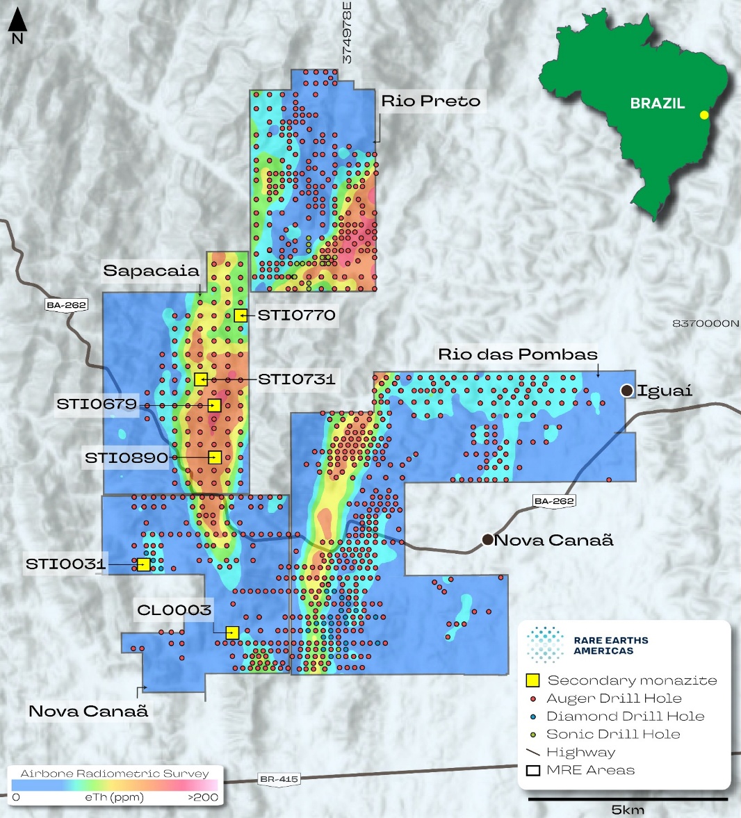
Note: Figure prepared by Rare Earths Americas, 2025. Map underlay from the regional airborne radiometric survey.
Date: 31 October 2025 |
|
Page 7-6 |
|
|
|
Alpha Project Bahia, Brazil Technical Report Summary |
Table 7‑2: Intercepts with Geochemical Indicative of Secondary Monazite Mineralization
Hole ID |
Target |
From |
To |
Interval1 (m) |
TREO |
NdPr2 |
DyTb3 |
SDI0031 |
Nova Canaã |
14.00 |
15.00 |
1.00 |
1.60 |
2,584 |
773 |
SDI0031 |
Nova Canaã |
15.00 |
16.00 |
1.00 |
2.30 |
5,711 |
1,075 |
STI0679 |
Sapacaia |
6.00 |
7.00 |
1.00 |
1.20 |
2,377 |
115 |
STI0679 (open at depth) |
Sapacaia |
7.00 |
7.17 |
0.17 |
1.30 |
2,440 |
114 |
STI0731 |
Sapacaia |
7.00 |
8.00 |
1.00 |
1.20 |
2,325 |
186 |
STI0731 |
Sapacaia |
10.00 |
11.00 |
1.00 |
6.90 |
12,368 |
513 |
STI0731 |
Sapacaia |
12.00 |
13.00 |
1.00 |
1.30 |
2,777 |
144 |
STI0770 |
Sapacaia |
20.00 |
21.00 |
1.00 |
1.60 |
2,988 |
142 |
STI0890 (open at depth) |
Sapacaia |
29.00 |
30.00 |
1.00 |
1.40 |
2,332 |
818 |
Notes:
7.2 Drilling
7.2.1 Overview
All drilling was completed on behalf of Rare Earths Americas, and consisted of auger, sonic and diamond core drilling.
Drilling Used in Estimation
The mineral resource estimate was based on all drilling data completed on the Project up to the completion of the final auger hole on July 16, 2024. No drilling was conducted after this date.
Assay data is available for all drill holes. Results from the final batch of assays were received on August 13, 2024. This date represents the data cutoff date for mineral resource estimate. No new drilling results or assay data have been received after this date.
Drilling Excluded for Estimation Purposes
All drill data obtained by Rare Earth Americas was used for resource estimation purposes.
Date: 31 October 2025 |
|
Page 7-7 |
|
|
|
Alpha Project Bahia, Brazil Technical Report Summary |
Drilling Methods
Between March 2022 and July 2024, Rare Earths Americas conducted:
Additionally, a roto-sonic drill rig (Eijkelkamp Compact RotoSonic V) was employed to drill:
As of August 13, 2024, drill data cut-off date for estimation purposes, lithology data were available for all drill holes.
A drill summary table for the drill holes used in estimation is provided in Table 7‑3 for each mineral resource area. Collar locations are shown in Figure 7‑3.
Drilling Since Database Cut-off Date
No drilling has been completed at the Project since the resource estimation cut-off date.
7.2.2 Drill Methods
No exploration drilling for rare earths was conducted on the property prior to Rare Earths Americas’ interest in the Project.
Date: 31 October 2025 |
|
Page 7-8 |
|
|
|
Alpha Project Bahia, Brazil Technical Report Summary |
Figure 7‑3: Property Drill Collar Location Plan
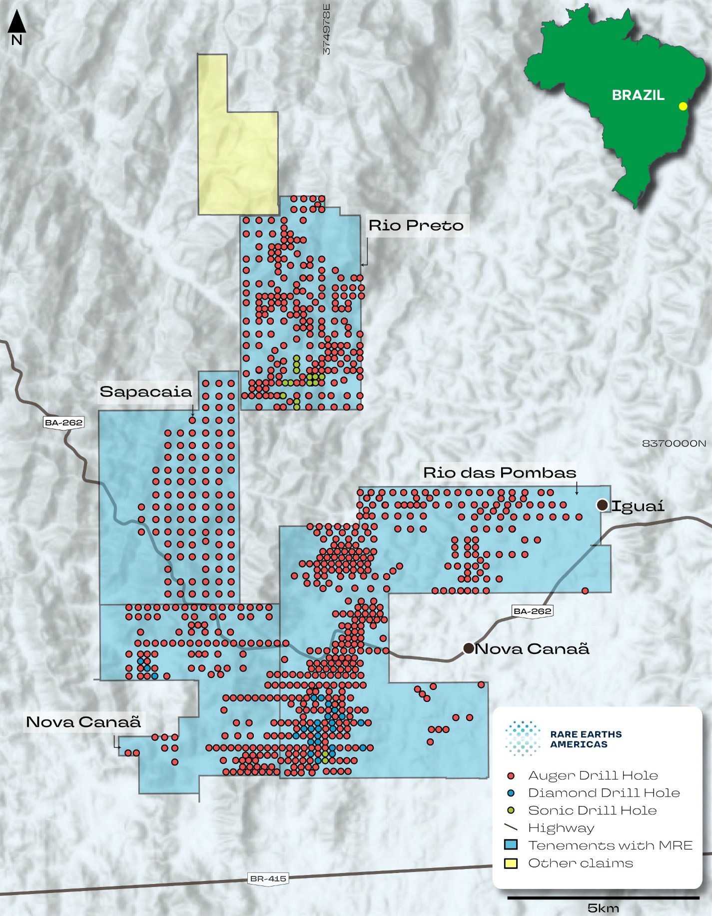
Note: Figure prepared by Rare Earths Americas, 2025. REA = Rare Earths Americas
Date: 31 October 2025 |
|
Page 7-9 |
|
|
|
Alpha Project Bahia, Brazil Technical Report Summary |
Table 7‑3: Drill Summary Table Supporting Mineral Resource Estimates
|
Type |
Count |
Average |
Maximum Depth (m) |
Drilled Meters |
Assayed Meters |
Rio Preto |
Sonic |
13 |
25.1 |
56.0 |
326.2 |
296 |
Auger |
261 |
16.1 |
30.0 |
4,191.5 |
3,998 |
|
Sapacaia |
Auger |
130 |
16.5 |
30.0 |
2,149.6 |
2,150 |
Nova Canaã |
Core |
7 |
49.2 |
70.8 |
344.2 |
228 |
Auger |
143 |
12.8 |
30.0 |
1,834.4 |
1,834 |
|
Rio das Pombas |
Core |
23 |
29.1 |
51.5 |
668.4 |
474 |
Sonic |
2 |
36.0 |
42.0 |
72.0 |
65 |
|
Auger |
402 |
18.0 |
30.0 |
7,246.3 |
7,241 |
|
Total |
Core |
30 |
33.8 |
70.8 |
1,013 |
702 |
Sonic |
15 |
26.5 |
56 |
398 |
361 |
|
Auger |
936 |
16.5 |
30 |
15,422 |
15,224 |
Auger
Between March 2022 and July 2024, Rare Earths Americas conducted a large-scale auger drill program across the property totaling 15,422 m in 936 holes. Auger drilling was carried out by Alpha Minerals Brazil Participações Ltda., a wholly owned subsidiary of Rare Earth Americas, using a handheld petrol-powered auger.
Auger drilling was conducted using a 0.05 m diameter x 0.4 m long clay soil auger bucket with 0.5 m to 1 m long rods. The auger bucket was advanced by adding rods until either groundwater was reached (which degrades sample quality) or refusal due to rock or hard saprolite. Auger drilling has a maximum operational depth limit of 30 m, with the average hole depth being 16 m.
Each bucket generated approximately 1.5 kg of sample material, which was recovered directly from the auger bucket, and placed onto a white polypropylene tarp to align with its likely in-situ position, geologically logged in the field, and a representative fraction was retained in a chip tray for reference.
Each auger sample was photographed in its natural condition before transport to the exploration facility, showing auger hole number and drill run lengths.
Sonic
Between October 2023 and February 2024, Rare Earths Americas conducted a targeted sonic drill program primarily focused on the southern portion of the Rio Preto deposit area and totaling 398 m in 15 holes. Sonic drilling was carried out by Brazil Royalty Corp. Participações e Investimentos Ltda under contract to Alpha Minerals, using an Eijkelkamp Compact RotoSonic V.
Date: 31 October 2025 |
|
Page 7-10 |
|
|
|
Alpha Project Bahia, Brazil Technical Report Summary |
Sonic drilling using a 2 m long single wall barrel to obtain a 7.6 cm diameter core or a 2 m long double wall core barrel to obtain a 6.8 cm diameter core. The drill string was advanced until encountering rock, hard boulders, or operational limits.
When encountering the water table or poor recovery, an outer casing was used, and water was utilized as a drilling fluid to aid in extracting material from the core barrel. The maximum operational depth limit of the sonic drill rig was 60 m, with an average hole depth of 27 m at the Alpha Project.
Drill core was collected directly from the core barrel, placed in pre-labelled core trays, and run interval depths were recorded. The core was then transported to the exploration facility for further processing. The core was transported from the drill site to logging facilities in covered boxes with utmost care. At the logging facility, broken core was re-aligned to its original position as closely as possible.
The diamond and sonic drill core was measured to assess recovery, then geologically logged and photographed wet in core boxes immediately before sampling. Core photos showed sample numbers and drill run lengths. All drill cores were logged at exploration facilities by logging geologists.
Core Drilling
Between February 2024 and April 2024, Rare Earths Americas conducted a targeted diamond drill program at the southern portion of the Rio das Pombas deposit area totaling 1,013 m in 30 holes also using the RotoSonic rig with an operation depth limit of 200 m.
The average diamond drill hole depth is 38 m. Drill core was recovered from surface to the target depth. All core drill holes were completed using a 3.05 m long single wall barrel. Holes were collared using HQ drill, producing 63.5 mm diameter core, and advanced with NQ rods, producing 47.6 mm diameter core, once fresh, and unoxidized bedrock was encountered. Water was used as a drilling fluid as necessary and to aid in extruding material from the core barrel.
7.2.3 Logging
For auger, sonic and diamond drill holes, logging included qualitative determinations of primary and secondary lithology units, weathering profile units, as well as the color and textural characteristics of the soil and rock.
Global positioning system (GPS) coordinates and geological logging data for all drill holes were captured in a Microsoft Excel spreadsheet and uploaded to the Project database. These data were collected in sufficient detail to support mineral resource estimation.
McGarry Geoconsulting notes that the regolith domains are assigned using a chemical index of alteration (refer to Chapter 6.5). However, the relationship between calculated chemical index of alteration, weathering intensity, and rare earth element accumulation may vary between different locations and bedrock types. In addition to visual inspection of the core, additional physical and geochemical parameters should be used to ensure correct determination regolith domains.
Date: 31 October 2025 |
|
Page 7-11 |
|
|
|
Alpha Project Bahia, Brazil Technical Report Summary |
7.2.4 Recovery
Auger samples were checked by the technician at the rig to ensure they represented the interval drilled. Fallen material was removed before sample collection.
If poor recovery was encountered during sonic drilling, then drill speed was decreased. Persistent poor recovery at the beginning of a hole resulted in redrilling at a nearby location. Casing was used to minimize fallback.
Recovered auger sample material, and sonic and diamond drill core, was measured, and recovery expressed as a percentage recorded in the database. Recovery rates for auger drilling in regolith is 99%. The average recovery for sonic core drilling in regolith is 95%. The average recovery for diamond core drilling is 78% in regolith and 95% in rock.
For core drilling methods, poor recoveries less than 85% typically occur 5–10 m below surface in areas of unconsolidated cover. There was no observed relationship between sample recovery and grade or sample bias due to preferential loss or gain of fine or coarse material.
7.2.5 Collar Surveys
Drill collars were located using a handheld GPS with ±3–5 m horizontal accuracy (95% confidence) in open sky conditions. The datum used was SIRGAS 2000 UTM 24S. The digital elevation model used has a has a lateral resolution of 30 m and a typical vertical accuracy of ±10 m (90% confidence). The accuracy of the locations is sufficient to support the inferred mineral resource confidence classification assigned in Chapter 11.
7.2.6 Down Hole Surveys
No down hole surveys were completed on any of the drill holes due to their shallow depths. While several sonic and diamond core holes have depths up to 70.8 m, the vertical holes are expected to have limited deviation of the drill hole trace.
7.2.7 Drilled Versus True Thickness
All intercepts reported are down hole lengths.
The mineralization is interpreted to be flat in the weathered profile, so the drilling is vertically perpendicular to mineralization and drilled mineralization thickness is interpreted to correspond to true thickness. The selected vertical drill orientation is applicable to the horizontal regolith mineralization..
7.2.8 Drill Hole Spacing
The ion-adsorption clay mineralization formed by deep and widespread weathering of regional-scale rare earth element-enriched meta-plutonic rocks. This process results in laterally extensive rare earth element-enriched horizons within in regolith saprolite horizons. The continuity of saprolite, and rare earth enrichment within it, can be established at a low resolution with widely spaced drilling. Drill hole
Date: 31 October 2025 |
|
Page 7-12 |
|
|
|
Alpha Project Bahia, Brazil Technical Report Summary |
spacing varies across the Project area from a maximum grid size of 320 m spacings which is infill drilled using a diamond pattern to 225 m spacings. The distribution is sufficient to establish the degree of geological and grade continuity appropriate for an inferred mineral resource confidence classification.
At smaller scales, geomorphic and hydrological processes result in localized zones of rare earth depletion and enrichment, as well as removal of prospective regolith horizons due to erosion. These features are well defined in more densely drilled areas where infill drilling was conducted on a tighter grid spacing of 160 m. This spacing may be sufficient to support indicated mineral resource confidence categories, if sources of uncertainty associated with elevation accuracy and metallurgical recovery are addressed, and supported by an updated initial assessment.
7.2.9 Comment on Material Results and Interpretation
Drilling, collar surveying, and geological logging were completed in accordance with industry-standard practices for ionic adsorption clay deposits. Drill collars were located using handheld GPS (SIRGAS 2000 UTM 24S). No downhole surveys were conducted due to the shallow nature of the drilling, with auger, sonic, and core holes drilled to depths generally less than 50 m. The short, vertical holes are expected to exhibit minimal deviation, resulting in low positional uncertainty.
For auger samples which make up 93.5% of the resource database, recovery was consistently high, approaching 100%. Diamond and sonic drilling methods make up 4.3% and 2.2% of the resource database respectively. For sonic drilling recovery in regolith was 95%. For diamond drilling recovery in regolith was 78%. Recovery was measured systematically and recorded in the project database. No correlation between recovery and grade was observed, and there is no indication of sampling bias from gain or loss of specific size fractions. Drilling methods, recovery rates, and logging procedures are considered appropriate to support mineral resource estimation.
The geological model is consistent with a regolith-hosted rare earth deposit, where mineralization occurs as ion-adsorbed clays within the weathered profile. The typical profile includes a leached upper soil and mottled zone, underlain by a saprolite horizon that hosts the majority of rare earth element enrichment. Mineralization is laterally continuous and flat lying, with vertical drilling producing intercepts that closely approximate true thickness.
Drilling has consistently intersected significant rare earth element-bearing saprolite, frequently exhibiting magnet rare earth oxide (MREO) enrichment with depth. More recent drilling has identified high-grade monazite sand mineralization associated with the Volta do Rio Suite, a geologically prospective unit extending across tenement area.
Drill hole spacing ranges from approximately 320 m (with diamond-pattern infill) to 225 m, sufficient to support an inferred mineral resource confidence classification. In localized areas with 160 m spacing, data density may support an indicated classification.
Based on the available data, drilling and logging are adequate to support mineral resource estimation.
7.3 Hydrogeology
Detailed hydrological investigations have not yet commenced for this early-stage project.
Date: 31 October 2025 |
|
Page 7-13 |
|
|
|
Alpha Project Bahia, Brazil Technical Report Summary |
Auger drilling completed to date has recorded depths at which drilling was halted due to water inflow into the drill holes. Those data are summarized in Table 7‑4 for each deposit area. In general, water-related stoppages occur infrequently across all deposit areas, typically in proximity to drainage channels at depths of 10–20 m.
In such places, results may be indicative of local groundwater conditions. The mineral resource model and associated constraining pit shells often extend well below these recorded depths, highlighting the requirement for dedicated hydrological characterization work as the Project advances.
Table 7‑4: Summary of water-related drilling stoppages in deposit areas
Target |
Water Stoppage |
Holes Stopped (%) |
Mean Stoppage Depth (m) |
Comments |
Rio Preto |
49 |
19 |
17.6 |
Water in auger drilling distributed across the deposit and is more common in holes next to drainage channels and rivers. The majority of holes ended in rock. |
Sapacaia |
30 |
23 |
18.2 |
Water in auger drilling distributed across the deposit and is more common in holes next to drainage channels and rivers. The majority of holes ended in rock. |
Nova Canaã |
12 |
8 |
9.8 |
Water stoppages are limited to areas surrounding the confluence of drainage channels in the eastern portion of the tenement surrounding a drainage channel |
Rio das Pombas |
64 |
16 |
15.9 |
Water stoppages predominantly occur in the northern portion of the deposit and in the east in areas surrounding the Rio das Pombas |
7.4 Geotechnical
Detailed geotechnical investigations have not yet commenced.
Core recovery data collected as part of drill hole logging indicated that there was no observed relationship between sample recovery and grade or sample bias due to preferential loss or gain of fine or coarse material (refer to Chapter 7.2.4.)
Date: 31 October 2025 |
|
Page 7-14 |
|
|
|
Alpha Project Bahia, Brazil Technical Report Summary |
8.0 SAMPLE PREPARATION, ANALYSES, AND SECURITY
8.1 Sampling Methods
Auger, sonic and drill core sub-samples submitted for assaying had an average weight of 1 kg. Grab samples had an average weight of 1 kg. For all sample types, field duplicates were completed at a frequency of 1:20 samples.
8.1.1 Auger
Collected sample interval lengths were 1 m, with some variation depending on sample recovery and geological unit boundaries.
Auger samples were sieved through a 10 x 10 mm screen. The oversized material was mechanically pulverized and re-combined with the undersized material on a plastic tarpaulin. The sample was homogenized by working it back and forth on the tarpaulin and then split using the cone and quarter method to produce sub-samples for assaying and archiving. The split for assay was placed in pre-numbered sample bags for shipment to the laboratory, while the remaining portion was bagged and stored onsite in a secure warehouse.
Samples were processed with natural moisture content, and those too wet for effective screening were air-dried naturally prior to processing.
To minimize cross-contamination, sampling tools were cleaned using water and compressed air between samples. Any plastic sheeting or tarpaulins used in sample collection and preparation were replaced between samples.
8.1.2 Sonic and Core
Core from sonic drilling was split to obtain quarter core sub-samples for assaying. Core sample intervals were typically 1 m in length, with a minimum of 0.55 m and a maximum of 2.0 m, taking into account lithological boundaries. The right side of the core was consistently sampled, and the bottom half retained in the core tray for archiving. The core was split into two quarter-core samples using a knife. One quarter-core sample was designated for assay testing, while the other was preserved as an archive sample. The quarter-core sample allocated for assay was placed in pre-numbered sample bags and prepared for shipment to the laboratory for analysis. The remaining half of the core was retained in the core tray for reference.
8.1.3 Grab Samples
Grab samples are collected from outcropping material using a rock hammer to obtain fragments of material for analysis. Grab samples represent single location points and do not represent a continuous sample along any length of the mineralized system. After collection in the field, grab
Date: 31 October 2025 |
|
Page 8-1 |
|
|
|
Alpha Project Bahia, Brazil Technical Report Summary |
samples were placed in sealed plastic bags labelled with sample IDs inside and transported to the company’s secure warehouse.
8.2 Sample Security Methods
Sample chain of custody was wholly managed by Rare Earths Americas.
After collection, exploration samples were bagged in sealed plastic bags, placed into polyweave sacks, labelled with the sample numbers, and transported to the company’s warehouse.
A local courier transported the samples to the analytical laboratory. A copy of all waybills related to the sample forwarding was secured from the expediter. An electronic copy of each submission was forwarded to the laboratory to advise them of the incoming sample shipment.
Once the samples arrived at the laboratory, Rare Earths Americas was notified by laboratory manager and any non-compliance was reported. The laboratory checked the packages and at the Report date, had not notified Rare Earths Americas of any sample-related security issues.
8.3 Density Determinations
Density measurements were completed on 163 fragments of sonic drill core, typically about 10 cm in length and 300 cm3 in volume, collected from across deposit. The water displacement method was used for density measurement.
A representative sample was selected from the drill core and dried in an oven for 24 hours at 60ºC. The sample was weighed both before and after drying so that the moisture content of the samples can be calculated.
The dry bulk density of the sample was determined using the displacement method once the sample was dry. Porous regolith samples were tightly covered in plastic wrap prior to immersion in water to prevent the sample from disintegrating in water. Care was taken to avoid trapping air spaces between the plastic wrap and the sample. The temperature of the water was measured to determine its density for use in the following equation:

All measurements were completed by Rare Earths Americas personnel and are summarized in Table 8‑1. Simple averages generated for each material type were assigned to mineral resource models for each deposit.
Date: 31 October 2025 |
|
Page 8-2 |
|
|
|
Alpha Project Bahia, Brazil Technical Report Summary |
Table 8‑1: Bulk Density Determinations
Material |
Count |
Avg. Moisture (%) |
Dry Bulk Density (t/m3) |
||
Min |
Max |
Average |
|||
Mottled Zone |
77 |
9.4 |
1.4 |
2.1 |
1.7 |
Saprolite |
86 |
5.5 |
1.3 |
2.2 |
1.7 |
Total |
163 |
7.3 |
1.3 |
2.2 |
1.7 |
8.4 Analytical and Test Laboratories
SGS Geosol in Vespasiano, Minas Gerais, Brazil (SGS Geosol) has been the primary assay laboratory for the Project since mineral exploration sampling commenced in March 2022. SGS Geosol is independent of Rare Earths Americas and holds ISO 9001 certification and 17025 accreditations. Approximately 74% of the assays (3,642 samples) in the database were generated by SGS Geosol.
In early 2024, Rare Earths Americas began periodically sending drill samples for preparation to ALS Belo Horizonte, Brazil (ALS Belo Horizonte) and with assaying completed at the ALS Lima facility in Peru (ALS Lima). ALS Belo Horizonte and ALS Lima are independent of Rare Earths Americas, and both hold ISO 17025 accreditations and ISO 9001 certification. Approximately 26% of the assays (1,293 samples) in the database were generated by ALS Lima.
8.5 Sample Preparation
At SGS Geosol, samples were initially dried at 105ºC for 24 hours. Samples were crushed to 75% passing 3 mm and the sample weight was recorded. The sample was reduced on a rotary splitter and then 250–300 g of the sample was pulverized to 95% passing 75 µm. A 50 g aliquot was assayed. Residual coarse crush and pulp material was returned to Rare Earths Americas for secure storage at the project.
ALS Belo Horizonte prepared samples in the same manner as at SGS Geosol, with the exception of the pulverization step, where 250–300 g of the sample was pulverized to 85% passing 75 µm. Residual coarse crush and pulp material was returned to Rare Earths Americas for secure storage at the project.
8.6 Analysis
SGS Geosol used a lithium borate fusion followed by inductively-coupled plasma mass spectrometry (ICP-MS) determination for a multi-element suite (SGS Geosol code IMS95A). This method provides a total rare earth element analysis, and values for the potentially deleterious elements uranium and thorium to the lower limits of detection presented in Table 8‑2.
The assay technique used for major oxides and components was lithium borate fusion followed by ICP optical emission spectroscopy (OES) analysis (SGS Geosol code ICP95A). ALS Lima used lithium borate fusion followed by an ICP-MS determination (ALS code ME-MS81), to generate a multi-element
Date: 31 October 2025 |
|
Page 8-3 |
|
|
|
Alpha Project Bahia, Brazil Technical Report Summary |
suite. This method provides a total rare earth element analysis, and values for the potentially deleterious elements uranium and thorium to the lower limits of detection (refer to Table 8‑2). The assay technique used for major oxides and components was lithium borate fusion followed by ICP-OES (ALS code ME-ICP06).
Table 8‑2: Elemental Detection Limits, SGS Geosol and ALS Lima
Element |
SGS Geosol (ppm) |
ALS Lima (ppm) |
La |
0.10 |
0.1 |
Ce |
0.10 |
0.1 |
Pr |
0.05 |
0.02 |
Nd |
0.10 |
0.1 |
Sm |
0.10 |
0.03 |
Eu |
0.05 |
0.02 |
Gd |
0.05 |
0.05 |
Tb |
0.05 |
0.05 |
Dy |
0.05 |
0.05 |
Ho |
0.05 |
0.05 |
Er |
0.05 |
0.03 |
Tm |
0.05 |
0.01 |
Yb |
0.10 |
0.03 |
Lu |
0.05 |
0.01 |
Y |
0.05 |
0.05 |
U |
0.05 |
0.05 |
Th |
0.10 |
0.05 |
8.7 Quality Assurance and Quality Control
All exploration conducted was accompanied by a QA/QC program implemented by Rare Earths Americas geologists following guidelines provided by geochemist Dr. Dennis Arne (Arne, 2023). This program included the systematic insertion of certified reference materials (CRMs), blank material, and the collection of field duplicate samples along with the exploration samples. For resource development drilling, QA/QC samples were inserted in the following proportions:
QA/QC sample results were monitored by the exploration team independently from the analytical laboratories and were periodically reviewed by McGarry Geoconsulting.
Date: 31 October 2025 |
|
Page 8-4 |
|
|
|
Alpha Project Bahia, Brazil Technical Report Summary |
8.7.1 Certified Reference Materials
The CRMs used for this program were supplied by Ore Research & Exploration Pty Ltd of Perth, Australia (OREAS). The selection of a suitable CRM is dependent on the type of material being sampled. Lower-grade CRMs are used for ionic-clay mineralization. OREAS 460 is used where previous analyses have indicated the presence of very high rare earth element levels. The CRMs were submitted as “blind” control samples not identifiable by the laboratory.
CRM Results SGS Geosol IMS95A
For SGS method IMS95A, rare earth elements and yttrium, and potentially deleterious elements thorium and uranium, CRM assay results are tabulated by CRM type in Table 8‑3 to Table 8‑8 for:
Example control plots for CRM OREAS 100a are shown in Figure 8‑1.
Table 8‑3: SGS IMS95A Results: OREAS 25a
Element |
CRM Grade |
CRM Std. Dev. |
Assay Avg. |
Avg. Bias |
La |
23.3 |
1.1 |
23.9 |
3 |
Ce |
50.8 |
1.6 |
50.2 |
-1 |
Pr |
5.3 |
0.2 |
5.4 |
1 |
Nd |
20.0 |
0.6 |
20.2 |
1 |
Sm |
3.9 |
0.2 |
4.0 |
2 |
Eu |
0.8 |
0.0 |
0.7 |
-8 |
Gd |
3.8 |
0.2 |
4.1 |
7 |
Tb |
0.7 |
0.1 |
0.7 |
2 |
Dy |
4.3 |
0.2 |
4.3 |
0 |
Ho |
0.9 |
0.0 |
0.9 |
-1 |
Er |
2.8 |
0.2 |
2.8 |
1 |
Yb |
2.9 |
0.2 |
3.0 |
5 |
Lu |
0.4 |
0.0 |
0.4 |
-2 |
Y |
25.1 |
1.5 |
25.7 |
2 |
Th |
16.4 |
0.8 |
17.4 |
6 |
U |
3.5 |
0.1 |
3.5 |
0 |
Total rare earth element |
145.4 |
Number of CRMs |
49.0 |
|
Note: La = lanthanum, Ce = cerium, Pr = praseodymium, Nd = neodymium, Sm = samarium, Eu = europium, Gd = gadolinium, Tb = terbium, Dy = dysprosium, Ho = holmium, Er = erbium, Yb = ytterbium, Lu = lutetium, Y = yttrium, Th = thorium, U = uranium.
Date: 31 October 2025 |
|
Page 8-5 |
|
|
|
Alpha Project Bahia, Brazil Technical Report Summary |
Table 8‑4: SGS IMS95A Results: OREAS 30a
Element |
CRM Grade |
CRM Std. Dev. |
Assay Avg. |
Avg. Bias |
La |
28.9 |
1.8 |
29.5 |
2 |
Ce |
58.0 |
3.2 |
58.4 |
1 |
Pr |
7.1 |
0.6 |
6.9 |
-2 |
Nd |
27.4 |
1.6 |
27.4 |
0 |
Sm |
5.7 |
0.4 |
5.7 |
1 |
Eu |
1.8 |
0.1 |
1.8 |
1 |
Gd |
5.2 |
0.2 |
5.3 |
2 |
Tb |
0.8 |
0.1 |
0.7 |
-3 |
Dy |
4.2 |
0.2 |
4.2 |
1 |
Ho |
0.7 |
0.1 |
0.8 |
3 |
Er |
1.9 |
0.2 |
2.0 |
3 |
Yb |
1.5 |
0.1 |
1.6 |
2 |
Lu |
0.2 |
0.0 |
0.2 |
0 |
Y |
19.4 |
1.1 |
19.4 |
0 |
Th |
3.7 |
0.3 |
7.1 |
91 |
U |
1.4 |
0.1 |
1.4 |
0 |
Total rare earth element |
163.0 |
Number of CRMs |
129.0 |
|
Table 8‑5: SGS IMS95A Results: OREAS 100a
Element |
CRM Grade |
CRM Std. Dev. |
Assay Avg. |
Avg. Bias |
La |
260.0 |
13.0 |
256.4 |
-1 |
Ce |
463.0 |
29.0 |
464.7 |
0 |
Pr |
47.1 |
4.0 |
45.4 |
-4 |
Nd |
152.0 |
14.0 |
145.2 |
-4 |
Sm |
23.6 |
0.7 |
23.8 |
1 |
Eu |
3.7 |
0.4 |
3.6 |
-4 |
Gd |
23.6 |
2.2 |
21.2 |
-10 |
Tb |
3.8 |
0.3 |
3.4 |
-10 |
Dy |
23.2 |
0.9 |
22.9 |
-1 |
Ho |
4.8 |
0.2 |
4.7 |
-2 |
Er |
14.9 |
0.9 |
14.9 |
0 |
Yb |
14.9 |
0.5 |
15.0 |
0 |
Lu |
2.3 |
0.2 |
2.1 |
-5 |
Y |
142.0 |
6.0 |
131.4 |
-7 |
Th |
51.6 |
4.3 |
50.3 |
-2 |
U |
135.0 |
11.0 |
130.2 |
-4 |
Total rare earth element |
1,181.2 |
Number of CRMs |
110.0 |
|
Date: 31 October 2025 |
|
Page 8-6 |
|
|
|
Alpha Project Bahia, Brazil Technical Report Summary |
Table 8‑6: SGS IMS95A Results: OREAS 106
Element |
CRM Grade |
CRM Std. Dev. |
Assay Avg. |
Avg. Bias |
La |
54.0 |
3.0 |
50.7 |
-6 |
Ce |
137.0 |
11.0 |
134.6 |
-2 |
Pr |
19.7 |
1.2 |
19.6 |
-1 |
Nd |
84.0 |
5.0 |
86.4 |
3 |
Sm |
20.7 |
1.5 |
20.3 |
-2 |
Eu |
2.0 |
0.2 |
1.9 |
-4 |
Gd |
18.2 |
1.3 |
18.1 |
-1 |
Tb |
3.1 |
0.2 |
3.0 |
-5 |
Dy |
19.0 |
1.1 |
18.7 |
-1 |
Ho |
3.9 |
0.3 |
4.0 |
1 |
Er |
12.2 |
0.7 |
12.0 |
-2 |
Yb |
12.1 |
0.6 |
12.2 |
0 |
Lu |
1.7 |
0.1 |
1.7 |
1 |
Y |
644.0 |
30.0 |
638.6 |
-1 |
Th |
1,143.0 |
34.0 |
1,117.0 |
-2 |
Total rare earth element |
1,032 |
Number of CRMs |
50.0 |
|
Table 8‑7: SGS IMS95A Results: OREAS 147
Element |
CRM Grade |
CRM Std. Dev. |
Assay Avg. |
Avg. Bias |
La |
698.3 |
26.7 |
691.9 |
-1 |
Ce |
1,197.6 |
73.2 |
1,155.0 |
-4 |
Pr |
121.6 |
2.7 |
115.3 |
-5 |
Nd |
378.6 |
18.9 |
364.6 |
-4 |
Sm |
47.9 |
3.4 |
45.9 |
-4 |
Eu |
10.2 |
0.6 |
9.8 |
-4 |
Gd |
21.8 |
0.9 |
23.0 |
5 |
Tb |
2.3 |
0.3 |
2.1 |
-11 |
Dy |
8.5 |
0.7 |
8.6 |
0 |
Ho |
1.3 |
0.2 |
1.2 |
-8 |
Er |
2.8 |
0.3 |
2.6 |
-6 |
Yb |
1.6 |
0.2 |
1.7 |
5 |
Y |
27.6 |
1.2 |
27.2 |
-1 |
Th |
95.5 |
3.4 |
88.7 |
-7 |
Total rare earth element |
2,616 |
Number of CRMs |
208.0 |
|
Date: 31 October 2025 |
|
Page 8-7 |
|
|
|
Alpha Project Bahia, Brazil Technical Report Summary |
Table 8‑8: SGS IMS95A Results: OREAS 460
Element |
CRM Grade |
CRM Std. Dev. |
Assay Avg. |
Avg. Bias |
La |
1,369.3 |
75.1 |
1,309.0 |
-4 |
Ce |
1,798.2 |
72.2 |
1,772.4 |
-1 |
Pr |
243.7 |
8.5 |
231.1 |
-5 |
Nd |
781.3 |
46.7 |
769.5 |
-2 |
Sm |
107.4 |
3.4 |
101.4 |
-6 |
Eu |
22.7 |
1.0 |
21.9 |
-4 |
Gd |
50.1 |
3.0 |
52.0 |
4 |
Tb |
4.8 |
0.2 |
4.7 |
-2 |
Dy |
19.8 |
0.8 |
19.2 |
-3 |
Ho |
2.8 |
0.2 |
2.7 |
-2 |
Er |
6.0 |
0.3 |
5.7 |
-4 |
Yb |
3.9 |
0.3 |
3.7 |
-6 |
Lu |
0.5 |
0.0 |
0.5 |
-12 |
Y |
59.7 |
2.6 |
57.7 |
-3 |
Th |
115.9 |
3.3 |
113.7 |
-2 |
U |
4.2 |
0.2 |
4.1 |
-3 |
Total rare earth element |
4,470 |
Number of CRMs |
194.0 |
|
Figure 8‑1: SGS Example CRM Control Plot OREAS 100a
|
|
|
|
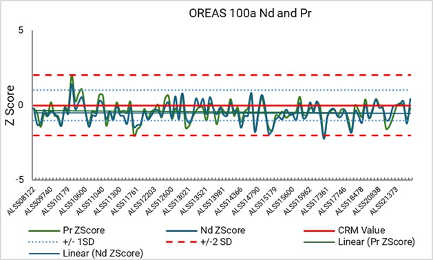
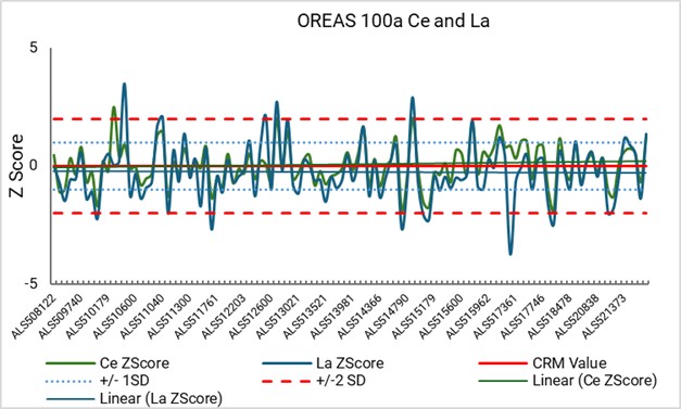
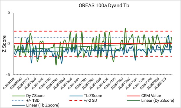
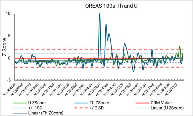
Note: Figure prepared by McGarry Consulting, 2025.
Date: 31 October 2025 |
|
Page 8-8 |
|
|
|
Alpha Project Bahia, Brazil Technical Report Summary |
CRM Results ALS ME-MS81
For ALS method ME-MS81, rare earth elements and yttrium, and potentially deleterious elements thorium and uranium, CRM assay results are tabulated by CRM type in Table 8‑9 to Table 8‑12. Example control plots for CRM OREAS 100a are shown in Figure 8‑2.
Overall CRMs performed very well with all but a handful of results within ±2 standard deviation control limits. Across all CRMs, rare earth and deleterious elements did not have consistent positive or negative bias and assay values were typically within a ±4% of the certified grades.
Table 8‑9: ALS ME-MS81 Results: OREAS 30a
Element |
CRM Grade |
CRM Std. Dev. |
Assay Avg. |
Avg. Bias |
La |
28.9 |
1.8 |
29.3 |
1 |
Ce |
58.0 |
3.2 |
59.0 |
2% |
Pr |
7.1 |
0.6 |
7.1 |
1 |
Nd |
27.4 |
1.6 |
29.1 |
6 |
Sm |
5.7 |
0.4 |
6.1 |
7 |
Eu |
1.8 |
0.1 |
1.8 |
4 |
Gd |
5.2 |
0.2 |
5.4 |
3 |
Tb |
0.8 |
0.1 |
0.7 |
-1 |
Dy |
4.2 |
0.2 |
4.2 |
0 |
Ho |
0.7 |
0.1 |
0.7 |
2 |
Er |
1.9 |
0.2 |
2.0 |
4 |
Yb |
1.5 |
0.1 |
1.6 |
3 |
Lu |
0.2 |
0.0 |
0.2 |
-3 |
Y |
19.4 |
1.1 |
20.2 |
4 |
Th |
3.7 |
0.3 |
3.8 |
2 |
U |
1.4 |
0.1 |
1.4 |
0 |
Total rare earth element |
163 |
Number of CRMs |
56.0 |
|
Table 8‑10: ALS ME-MS81 Results: OREAS 100a
Element |
CRM Grade |
CRM Std. Dev. |
Assay Avg. |
Avg. Bias |
La |
260.0 |
13.0 |
258.2 |
-1 |
Ce |
463.0 |
29.0 |
466.9 |
1 |
Pr |
47.1 |
4.0 |
46.5 |
-1 |
Nd |
152.0 |
14.0 |
152.7 |
0 |
Sm |
23.6 |
0.7 |
24.2 |
3 |
Eu |
3.7 |
0.4 |
3.6 |
-3 |
Gd |
23.6 |
2.2 |
21.1 |
-11 |
Tb |
3.8 |
0.3 |
3.6 |
-6 |
Dy |
23.2 |
0.9 |
23.1 |
0 |
Ho |
4.8 |
0.2 |
4.8 |
0 |
Er |
14.9 |
0.9 |
15.1 |
1 |
Yb |
14.9 |
0.5 |
15.2 |
2 |
Lu |
2.3 |
0.2 |
2.2 |
-4 |
Y |
142.0 |
6.0 |
138.6 |
-2 |
Date: 31 October 2025 |
|
Page 8-9 |
|
|
|
Alpha Project Bahia, Brazil Technical Report Summary |
Element |
CRM Grade |
CRM Std. Dev. |
Assay Avg. |
Avg. Bias |
Th |
51.6 |
4.3 |
49.7 |
-4 |
U |
135.0 |
11.0 |
133.0 |
-1 |
Total rare earth element |
1,179 |
Number of CRMs |
58.0 |
|
Table 8‑11: ALS ME-MS81 Results: OREAS 147
Element |
CRM Grade |
CRM Std. Dev. |
Assay Avg. |
Avg. Bias |
La |
698.3 |
26.7 |
703.3 |
1 |
Ce |
1,197.6 |
73.2 |
1,196.6 |
0 |
Pr |
121.6 |
2.7 |
118.6 |
-2 |
Nd |
378.6 |
18.9 |
383.4 |
1 |
Sm |
47.9 |
3.4 |
47.3 |
-1 |
Eu |
10.2 |
0.6 |
9.9 |
-3 |
Gd |
21.8 |
0.9 |
21.6 |
-1 |
Tb |
2.3 |
0.3 |
2.3 |
-1 |
Dy |
8.5 |
0.7 |
8.9 |
4 |
Ho |
1.3 |
0.2 |
1.3 |
-6 |
Er |
2.8 |
0.3 |
2.7 |
-2 |
Yb |
1.6 |
0.2 |
1.7 |
2 |
Y |
27.6 |
1.2 |
27.8 |
1 |
Th |
95.5 |
3.4 |
92.3 |
-3 |
Total rare earth element |
2,616 |
Number of CRMs |
50.0 |
|
Table 8‑12: ALS ME-MS81 Results: OREAS 460
Element |
CRM Grade |
CRM Std. Dev. |
Assay Avg. |
Avg. Bias |
La |
1,369.3 |
75.1 |
1,380.0 |
1 |
Ce |
1,798.2 |
72.2 |
1,851.8 |
3 |
Pr |
243.7 |
8.5 |
241.0 |
-1 |
Nd |
781.3 |
46.7 |
811.3 |
4 |
Sm |
107.4 |
3.4 |
106.0 |
-1 |
Eu |
22.7 |
1.0 |
22.4 |
-1 |
Gd |
50.1 |
3.0 |
49.4 |
-1 |
Tb |
4.8 |
0.2 |
4.9 |
2 |
Dy |
19.8 |
0.8 |
20.1 |
1 |
Ho |
2.8 |
0.2 |
2.8 |
0 |
Er |
6.0 |
0.3 |
6.2 |
3 |
Yb |
3.9 |
0.3 |
3.7 |
-5 |
Lu |
0.5 |
0.0 |
0.5 |
-3 |
Y |
59.7 |
2.6 |
60.7 |
2 |
Th |
115.9 |
3.3 |
113.7 |
-2 |
U |
4.2 |
0.2 |
4.1 |
-2 |
Total rare earth element |
4,470 |
Number of CRMs |
41.0 |
|
Date: 31 October 2025 |
|
Page 8-10 |
|
|
|
Alpha Project Bahia, Brazil Technical Report Summary |
Figure 8‑2: ALS Example CRM Control Plot OREAS 100a
|
|
|
|
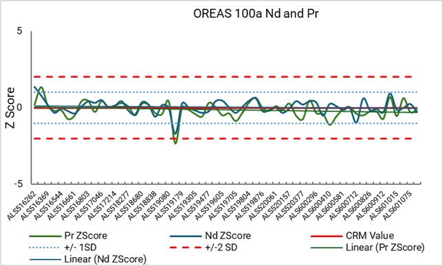
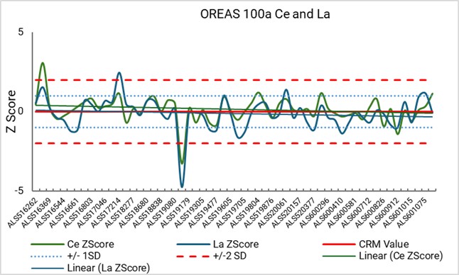
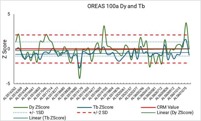
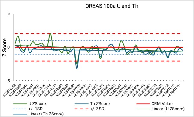
Note: Figure prepared by McGarry Consulting, 2025.
8.7.2 Blanks
Quartz sand was used as coarse blank material submitted with the core samples. An upper control line is set at a value of 10 times the lower limit of detection for the method used for analysis.
Blank SGS IMS95A
A total of 372 blank analyses were completed.
For abundant elements of interest such as cerium, lanthanum, neodymium and thorium, C the lower limit of detection was 0.1 ppm, and the control line was set at 1 ppm. For less abundant elements of interest such as praseodymium, dysprosium, terbium and uranium, the lower limit of detection is 0.05 ppm, and the control line is set at 0.5 ppm.
Blank control charts are shown in Figure 8‑3.
The majority of blank analyses for commercially significant elements neodymium, praseodymium, dysprosium and terbium are below the corresponding control line.
For abundant elements cerium, lanthanum and thorium a large proportion of blank analyses exceed the control limit by a small amount with nearly all (i.e. >98%) assays are below a 10-ppm limit. The
Date: 31 October 2025 |
|
Page 8-11 |
|
|
|
Alpha Project Bahia, Brazil Technical Report Summary |
correlation between element abundance and blank control failure suggests minor cross contamination, or carryover of elements, from exploration samples. The amount of carryover is not significant relative to the resource reporting grade.
Blank ALS ME-MS81
A total of 79 blank analyses were completed.
Blank control charts are shown in Figure 8‑4.
For commercially significant elements neodymium, praseodymium, dysprosium and terbium, the majority of assays are below the corresponding control line.
For abundant elements cerium and lanthanum, a large proportion of blank analyses exceed the control limit by a small amount with nearly all (i.e. >98%) assays are below a 10 ppm limit.
Figure 8‑3: SGS Control Plot Blanks
|
|
|
|
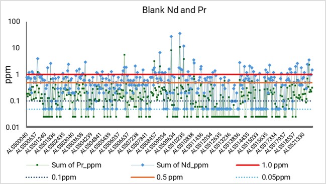
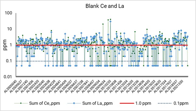
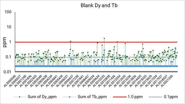
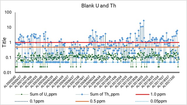
Note: Figure prepared by McGarry Consulting, 2025.
Date: 31 October 2025 |
|
Page 8-12 |
|
|
|
Alpha Project Bahia, Brazil Technical Report Summary |
Figure 8‑4: ALS Control Plot Blanks
|
|
|
|
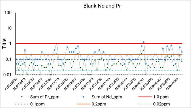
Note: Figure prepared by McGarry Consulting, 2025.
8.7.3 Field Duplicates
Sampling precision was monitored by submitting samples for repeat analysis.
Field Duplicates SGS Geosol IMS95A
A total of 929 duplicate analyses were completed by SGS Geosol. Scatter plots for each element are shown in Figure 8‑5.
There is a strong linear relationship between the original and duplicate values. Coefficient of determination (R2) values are typically >0.9 indicating a strong positive correlation between original and duplicate values. Despite the strong correlation, there are some outliers or deviations from the line especially at higher values, but these are relatively few. Neodymium had the lowest R2 value at 0.88 resulting from a repeat analysis of sample ALS507318 which returned a grade of 950 ppm vs. an original value of 111 ppm.
Field Duplicates ALS Lima
A total of 205 duplicate analyses completed by ALS Lima. Scatter plots for each element are shown in Figure 8‑6.
Date: 31 October 2025 |
|
Page 8-13 |
|
|
|
Alpha Project Bahia, Brazil Technical Report Summary |
There is a strong linear relationship between the original and duplicate values. Coefficient of determination (R2) values are typically >0.9 indicating a indicates a strong positive correlation between original and duplicate values.
8.8 Database
Exploration data is recorded directly into proprietary logging spreadsheet tables hosted on secure cloud servers. The spreadsheets are populated using locked picklists to minimize entry errors and ensure consistency. Tables are interlinked so that key metadata, such as hole IDs and total depths, are automatically attributed to corresponding logging records. Basic auto-validation tools are applied to check for logical errors, including ensuring correct from- and to-depth relationships.
Assay data is imported from laboratory certificates using lookup functions that match sample identifiers, reducing manual transcription errors. Density measurements and survey data are entered into the same system, maintaining a single integrated dataset for resource estimation.
Although these linked spreadsheets and validation functions improve data reliability, they are not a substitute for a dedicated commercial geological database system.
Original logging sheets, assay certificates, and survey files are archived digitally, with backups maintained on cloud servers. Routine copies of the database are saved to ensure data recovery capability in the event of corruption or accidental loss.
Figure 8‑5: SGS Field Duplicate Scatter Plots
|
|
|
|
|
|

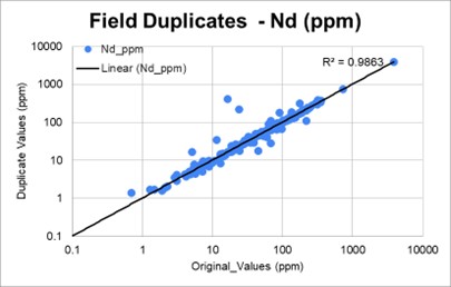

Date: 31 October 2025 |
|
Page 8-14 |
|
|
|
Alpha Project Bahia, Brazil Technical Report Summary |
|
|
|
|
|
|


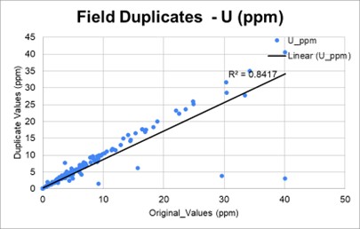

Note: Figure prepared by McGarry Consulting, 2025. Pr = praseodymium, Nd = neodymium, La = lanthanum, Ce = cerium, Dy = dysprosium, Gd = gadolinium, Th = thorium, U = uranium.
Figure 8‑6: ALS Field Duplicate Scatter Plots
|
|
|
|
|
|
|
|
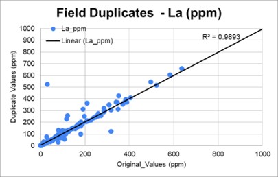


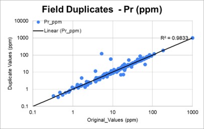
Date: 31 October 2025 |
|
Page 8-15 |
|
|
|
Alpha Project Bahia, Brazil Technical Report Summary |
|
|
|
|
|
|
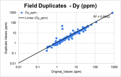
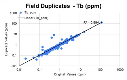

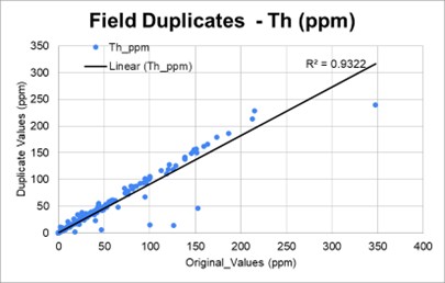
Note: Figure prepared by McGarry Consulting, 2025. Pr = praseodymium, Nd = neodymium, La = lanthanum, Ce = cerium, Dy = dysprosium, Gd = gadolinium, Th = thorium, U = uranium.
8.9 Qualified Person’s Opinion on Sample Preparation, Security, and Analytical Procedures
The results of the QA/QC samples summitted by Rare Earth Americas during exploration do not indicate significant issues with the analytical data.
The performance of CRM, blanks and field duplicates indicate satisfactory performance of field sampling protocols and assay laboratories in providing acceptable levels of precision and accuracy.
The density determinations are suitably representative for the estimation of inferred mineral resources. Rare Earths America should continue to collect density measurements on undisturbed samples obtained from sonic drill core.
The data verification programs undertaken on the data collected from the Project support the geological interpretations and the analytical and database quality, and therefore the data can be used for mineral resource estimation.
Date: 31 October 2025 |
|
Page 8-16 |
|
|
|
Alpha Project Bahia, Brazil Technical Report Summary |
9.0 DATA VERIFICATION
9.1 Internal Data Verification
9.1.1 Exploration Data
Rare Earth Americas maintains all exploration data in a secure, web-based database that incorporates automated validation protocols. The system performs continuous checks for overlapping from–to intervals within assay and geological tables and enforces standardization of lithology, alteration, and assay codes through defined pick lists to ensure consistency in data entry.
All drill hole data is routinely exported from the database and imported into Leapfrog Geo software (version 25.1) for independent validation. Standard verification procedures include:
Visual validation is also undertaken by the Rare Earth Americas’ geology manager to identify spurious collar coordinates.
9.2 Data Verification by Qualified Person
9.2.1 Karst Geo Solutions
Karst Geo Solutions completed a site visit (refer to Chapter 2.4.2).
The following conclusions were reached as a result of the site visit:
The majority of the data, drilling, and geological records were found to be well maintained by Rare Earths Americas personnel and comprehensive field procedures were developed.
9.2.2 McGarry Geoconsulting
McGarry Geoconsulting performed a site visit (see Chapter 2.4.1).
Date: 31 October 2025 |
|
Page 9-1 |
|
|
|
Alpha Project Bahia, Brazil Technical Report Summary |
McGarry Geoconsulting has compiled and verified all exploration data provided by Rare Earth Americas to generate the mineral resources disclosed in this Report.
McGarry Geoconsulting is satisfied that the data has been appropriately verified and is adequate to support the mineral resource estimates presented in this report.
McGarry Geoconsulting concluded that:
Date: 31 October 2025 |
|
Page 9-2 |
|
|
|
Alpha Project Bahia, Brazil Technical Report Summary |
10.0 MINERAL PROCESSING AND METALLURGICAL TESTING
10.1 Introduction
The mineral resource estimate is supported by a program of bench-scale leachability testing conducted on exploration drill samples from all deposit areas (see discussion in Chapter 10.3 and Chapter 10.4). The results provide the metallurgical basis for reporting rare earth element mineral resources.
Samples were collected at 1 m intervals throughout the regolith profile in a subset of drill holes, providing vertical resolution and systematic coverage across the mineralized zones.
Leach recoveries for individual rare earth elements were derived from these results and incorporated into the block model to estimate in-situ grades and metallurgical recoveries. Recovered block values were calculated and used to support cut-off grade determinations.
Testing was performed using ammonium sulphate under controlled ion-exchange conditions selected to approximate the anticipated processing method, with the resulting average recoveries considered representative at a bulk scale due to the systematic sampling strategy and the close alignment between test conditions and the anticipated processing method.
10.2 Proposed Processing Method
The processing of ionic adsorption clay rare earth mineralization is an emerging technology that differs significantly from traditional hard rock rare earth extraction methods. Ionic adsorption clay deposits typically host rare earth elements loosely bound to clay particles near the surface. These rare earth elements are not locked within minerals but are instead adsorbed onto the surface of clay minerals, which allows for relatively simple extraction techniques.
The proposed processing route is based on ion-exchange leaching using ammonium sulphate ((NH₄)₂SO₄) solution under acidic conditions (target pH ≈ 2). The acidity enhances ion mobility and exchange efficiency, facilitating the desorption of rare earth elements from the clay matrix. The process takes advantage of the electrostatic nature of rare earth element adsorption onto clays, replacing the rare earth element³⁺ ions with NH₄⁺ ions from solution. This reaction occurs readily under ambient pressure and temperature, provided that solution chemistry (pH, ionic strength, contact time) is properly controlled.
The resulting slurry is then subjected to solid-liquid separation, typically through pressure or vacuum filtration, to produce a pregnant leach solution-enriched in rare earth elements. This pregnant leach solution is subsequently processed through chemical precipitation, where specific reagents—commonly oxalic acid or sodium carbonate—are added to selectively remove the dissolved rare earth elements from solution. The precipitated material, known as mixed rare earth concentrate, contains the suite of rare earth elements present in the deposit, except for cerium, which is only minimally recovered in this process due to its prevalent oxidized state. Depending on market requirements and product specifications, the mixed rare earth concentrate may undergo further purification and upgrading stages.
Date: 31 October 2025 |
|
Page 10-1 |
|
|
|
Alpha Project Bahia, Brazil Technical Report Summary |
Globally, only a limited number of ionic adsorption clay projects are in production outside of China. The technology remains relatively new, with few operations having progressed to commercial-scale development. In Brazil, the Serra Verde Project, operated by Serra Verde Pesquisa e Mineração Ltda., is currently the only known ionic adsorption clay operation in production, highlighting the early stage of adoption of this processing method within the country.
The technology in use at the Serra Verde operation is considered suitable for application at the Project and involves:
Compared to hard rock rare earth deposits, ionic adsorption clay processing avoids crushing, grinding, and high-temperature treatment, resulting in lower energy use and reduced environmental impact.
10.3 Test Laboratories
SGS Geosol in Lima, Peru was used to undertake bench-scale leaching tests during the period 2022 to 2023. ALS Geochemistry in Lima, Peru was used to undertake bench-scale leaching tests during the period 2023 to 2024. Both facilities are independent of Rare Earths Americas, and both hold ISO 17025
Date: 31 October 2025 |
|
Page 10-2 |
|
|
|
Alpha Project Bahia, Brazil Technical Report Summary |
accreditations and ISO 9001 certification. There are currently no globally recognized accreditations for metallurgical testwork.
10.4 Metallurgical Testwork
SGS Geosol performed bench-scale ionic exchange tests using an ammonium sulphate solution equivalent to approximately 0.5 M (SGS code ICM655) on 50 g sample aliquots. A total of 1,078 leach tests were completed on samples from 117 auger holes between 2022 and 2024.
ALS Lima carried out bench-scale ammonium sulphate ionic exchange tests using a 0.5 M ammonium sulphate solution (ALS code ME-MS19) on 30 g sample aliquots. A total of 1,154 leach tests were completed on samples from 56 auger holes between 2023 and 2024.
For both laboratories, the samples were agitated in ammonium sulphate solution for 20 minutes and then filtered. The resulting filtrate was collected, an aliquot diluted with 2% nitric acid, and analyzed by ICP-MS.
In total, 17% of drill holes were subject to 2,232 ammonium sulphate leach tests, of which 2,199 are within modelled deposit areas. Drill hole collar locations for holes with samples that underwent ionic exchange testing are presented in Figure 10-1.
Date: 31 October 2025 |
|
Page 10-3 |
|
|
|
Alpha Project Bahia, Brazil Technical Report Summary |
Figure 10‑1: Collar Locations, Metallurgical Testwork Samples
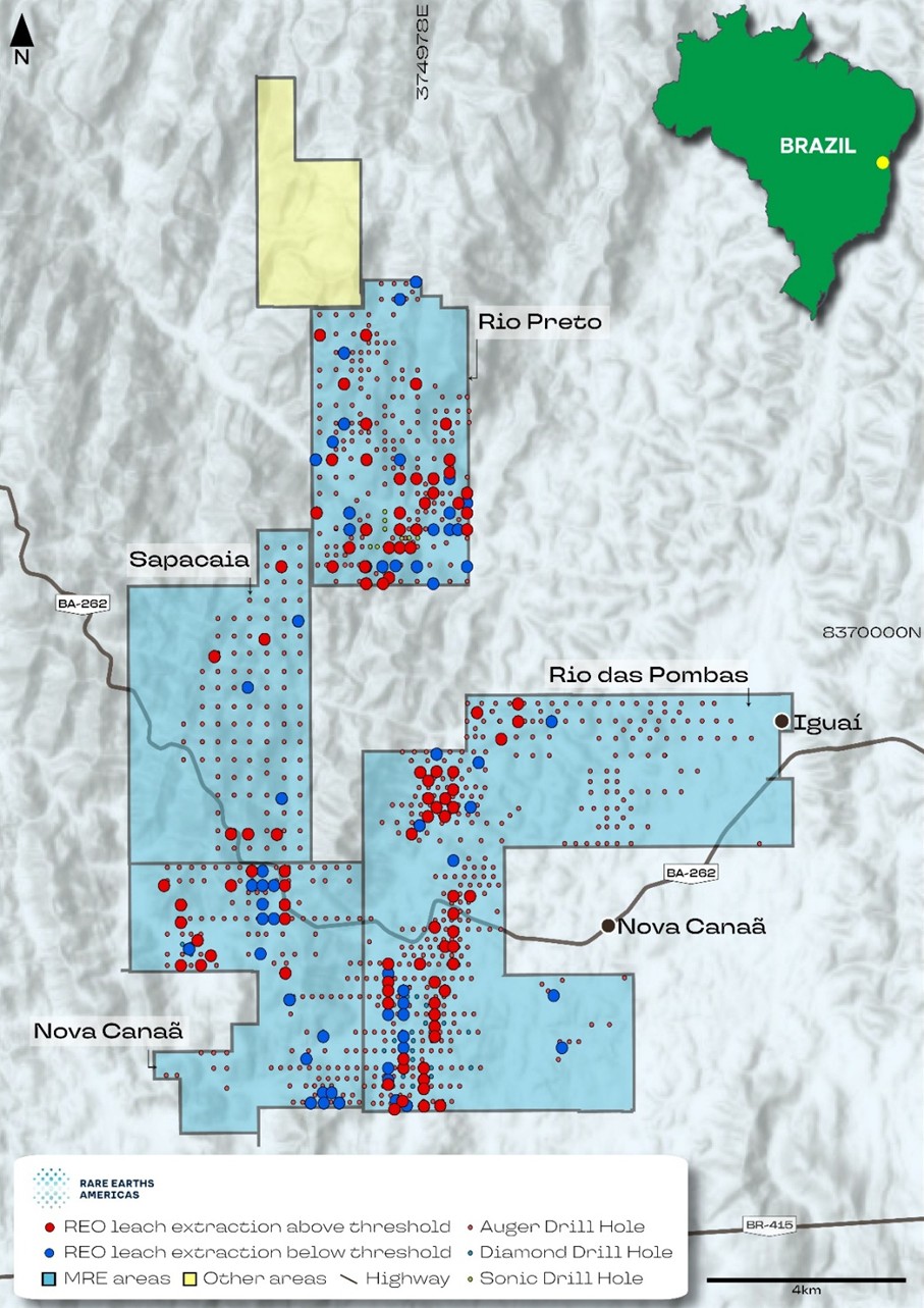
Note: Figure prepared by Rare Earths Americas, 2025.
10.5 Rare Earth Element Extraction Estimates
As of the date of this Report, 2,439 samples have been submitted for metallurgical testwork. The average TREO-CeO₂ extraction into leach solution across all deposit areas is 22%, with comparable extractions observed for the economically significant magnet rare earth oxides. Leach extraction varies both between, and within, deposit areas.
Date: 31 October 2025 |
|
Page 10-4 |
|
|
|
Alpha Project Bahia, Brazil Technical Report Summary |
Of the samples submitted, 807 samples (33%) contained saprolite with total rare earth oxide concentrations greater than a threshold of >209 ppm TREO–cerium oxide (CeO2) extracted into the leach solution. This threshold was applied to determine reasonable prospects for economic extraction, as detailed in the cut-off calculation provided in Chapter 11.11. Cerium was excluded from the threshold because it does not readily leach under the mild acid conditions typical of ionic clay processing. As a result, its extraction does not contribute to leach solution grades and is therefore not considered in determining potential economic cut-off parameters.
For samples above the selected threshold and representative of the mineral resource, the mean leach extraction for rare earth elements was 40%, with comparable extractions for the magnet rare earths neodymium, praseodymium, dysprosium, and terbium. The mean extraction for individual deposits is summarized in Table 10‑1 and recoveries by individual rare earth element are illustrated in Figure 10‑2.
Table 10‑1: Mean Leach Sample Recoveries by Deposit
|
Mean Extraction (%) |
Mean Extraction (%) |
||||||||||||||||||||||
|
Count |
TREO- |
Nd2O3 |
Pr6O11 |
Dy2O3 |
Tb4O7 |
Count |
TREO- |
Nd2O3 |
Pr6O11 |
Dy2O3 |
Tb4O7 |
||||||||||||
Rio Preto |
688 |
|
17.01 |
|
17.5 |
|
15.9 |
|
17.8 |
|
18.8 |
|
211 |
|
39.0 |
|
39.5 |
|
36.5 |
|
40.1 |
|
37.4 |
|
Sapacaia |
190 |
|
21.27 |
|
23.5 |
|
20.5 |
|
24.2 |
|
21.6 |
|
50 |
|
50.3 |
|
55.1 |
|
48.7 |
|
53.7 |
|
49.8 |
|
Nova Canaã |
267 |
|
25.17 |
|
25.9 |
|
23.4 |
|
26.2 |
|
23.9 |
|
108 |
|
41.8 |
|
42.4 |
|
39.0 |
|
42.6 |
|
39.3 |
|
Rio das Pombas |
1,054 |
|
24.81 |
|
25.7 |
|
23.0 |
|
23.0 |
|
26.0 |
|
438 |
|
39.0 |
|
40.3 |
|
37.1 |
|
38.7 |
|
38.9 |
|
All |
2,199 |
|
22.34 |
|
23.0 |
|
20.6 |
|
21.9 |
|
23.1 |
|
807 |
|
40.1 |
|
41.3 |
|
37.9 |
|
40.5 |
|
39.2 |
|
Date: 31 October 2025 |
|
Page 10-5 |
|
|
|
Alpha Project Bahia, Brazil Technical Report Summary |
Figure 10‑2: Summary of Leach Test Results for Above Mineral Resource Estimate Threshold Samples
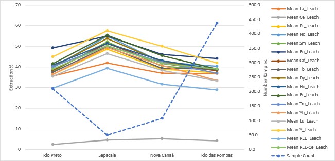
Note: Figure prepared by McGarry Consulting, 2025.
Block model rare earth element (REE) leach recovery values for were estimated from all available test results at each deposit, using the same parameters and methodology described in Section 11.11. Estimated leach extraction for TREO–CeO2, Nd2O3, Pr6O11, Dy2O3 and Tb4O7 attributable to the mineral resource are presented in Table 10‑2.
Table 10‑2: Mean Block Model Recovery Estimates
|
Mean Estimated Extraction (%) Blocks >1,000ppm TREO |
||||
|
TREO-CeO2 |
Nd2O3 |
Pr6O11 |
Dy2O3 |
Tb4O7 |
Rio Preto |
27.0 |
26.8 |
24.0 |
28.0 |
30.2 |
Sapacaia |
22.4 |
23.8 |
20.8 |
26.7 |
23.8 |
Nova Canaã |
29.9 |
33.8 |
30.4 |
30.3 |
24.7 |
Rio das Pombas |
34.6 |
34.9 |
30.7 |
35.5 |
31.9 |
All |
27.2 |
28.6 |
25.5 |
28.8 |
27.2 |
These leaching results were comparable to those published for ionic adsorption clay projects on adjacent properties and inferred that the ionic clay rare earth mineralization is amenable to ionic exchange
Date: 31 October 2025 |
|
Page 10-6 |
|
|
|
Alpha Project Bahia, Brazil Technical Report Summary |
leaching at standard temperatures, pH, and atmospheric pressure. Process optimization testwork is planned and will be advanced as the Project develops.
Infill drilling should delineate material most amenable to leaching and target discrete horizons and zones with high rare earth element contents by leaching.
10.6 Metallurgical Variability
Leach recovery samples were collected from exploration drillholes on a regular grid spacing across each deposit, ensuring spatial representativity of the metallurgical dataset. Samples were taken continuously downhole through the entire regolith profile, capturing both lateral and vertical variability within the mineralized zones. The sampling approach covered the full range of grades present in the deposits, and leach tests were performed on intervals representing both high- and low-grade material.
The sample distribution covered the defined saprolite mineralization domain used in the estimation, ensuring that the extraction data were representative of the mineral resource estimates.
10.7 Deleterious Elements
For ionic adsorption clay deposits in general, the most common deleterious elements are thorium and uranium due to their impact on product radioactivity, and iron and aluminum due to their influence on reagent consumption and pregnant leach solution chemistry.
Bench-scale leach tests were conducted to evaluate the deportment of deleterious elements, including thorium and uranium, into the pregnant leach solution (Table 10‑3). These tests indicated that both elements were largely immobile under the selected ion-exchange leaching conditions, with generally low levels detected in the pregnant leach solution.
Thorium and uranium were also estimated into the block model from exploration assays to assess their distribution and assess potential impacts on selective mining or waste management.
Additional metallurgical work is recommended. Bulk composite and variability testing will further assess these elements and confirm that impurity levels will not impact plant throughput, recovery, or product marketability.
No factors were identified to date that would preclude potential economic extraction or the generation of a marketable rare earth carbonate product at the project, although continued assessment of deleterious elements is recommended as the Project advances.
Date: 31 October 2025 |
|
Page 10-7 |
|
|
|
Alpha Project Bahia, Brazil Technical Report Summary |
Table 10‑3: Deleterious Element U and Th in Pregnant Leach Solution in Bench-Scale Tests
Deposit |
Count |
Uranium (U ppm) |
Thorium (Th ppm) |
||||
Average |
Minimum |
Maximum |
Average |
Minimum |
Maximum |
||
Rio Preto |
211 |
0.25 |
0.02 |
3.17 |
0.35 |
0.02 |
5.10 |
Sapacaia |
50 |
2.41 |
0.24 |
11.95 |
1.00 |
0.02 |
9.04 |
Nova Canaã |
108 |
0.35 |
0.02 |
1.92 |
0.88 |
0.05 |
12.45 |
Rio das Pombas |
438 |
0.18 |
0.02 |
4.06 |
0.33 |
0.01 |
6.64 |
Grand total |
807 |
0.34 |
0.00 |
11.95 |
0.44 |
0.01 |
12.45 |
10.8 Qualified Person’s Opinion on Data Adequacy
The metallurgical dataset is considered adequate to support the current mineral resource estimate. The bench-scale leach tests replicate the proposed ammonium sulphate ion-exchange process and are relevant to the ionic clay deposit class.
The systematic sampling captures both lateral and vertical variability, and the recoveries allow an inference of bulk-scale behavior at the current resource development stage.
It is recommended that future work include bulk composite and pilot-scale leach testing to evaluate potential comminution effects in transitional horizons, test material handling and leach solution flow, and refine leach extraction estimates across different regolith domains.
Continuous column leach testing should also be undertaken to replicate percolation behavior under process-representative conditions and validate leaching kinetics. These larger-scale tests should provide sufficient pregnant leach solution volumes for confirmatory work on mixed rare earth carbonate precipitation and purification, to establish product quality and recovery estimates through to a saleable product.
These programs should strengthen the metallurgical basis for the mineral resource estimate and support the economic assumptions in sufficient detail to support higher-confidence mineral resource categories and engineering studies.
Date: 31 October 2025 |
|
Page 10-8 |
|
|
|
Alpha Project Bahia, Brazil Technical Report Summary |
11.0 MINERAL RESOURCE ESTIMATES
11.1 Introduction
Geological and block modelling was undertaken Leapfrog version 2025.1 with the Edge extension. Statistical analysis was carried out using Snowden Supervisor software version 8.6.
The Alpha Project is sub-divided into four deposit areas for the mineral resource estimation. These areas are shown in Figure 7‑3. Deposit boundaries define areas characterized by consistent topographic trends, which exert a primary control on the distribution of ionic adsorption clay mineralization, and by airborne radiometric thorium equivalent anomalies associated with rare earth element mineralization. Where appropriate, deposit boundaries coincide with concession limits. The deposits are defined as follows (Table 11‑1):
The total area of the four deposit models is 53.1 km2. The total modelled volume is approximately 1,400 Mm3.
The modelled north–south extent of each area ranges from 2.4–7.5 km with a total extent of approximately 53 km2. The east–west extents range up to 10 km. The modelled thicknesses range from 2–65 m where the deposit was tested by sonic and core drilling. Where the deposit was tested by auger drilling (with a maximum operational limit of 30 m) thickness ranges to 39 m. The median thicknesses range from 23–29 m.
Date: 31 October 2025 |
|
Page 11-1 |
|
|
|
Alpha Project Bahia, Brazil Technical Report Summary |
Table 11‑1: Extents of the Mineral Resource Estimate Domains
|
Deposit |
Rio Preto |
Sapacaia |
Nova Canaã |
Rio das Pombas |
Extent (m) |
North–south |
5,510 |
5,980 |
2,390 |
7,530 |
East–west |
3,023 |
1,900 |
2,341 |
10,038 |
|
|
Minimum |
5 |
7 |
7 |
2 |
25 Percentile |
19 |
19 |
22 |
23 |
|
Median: |
23 |
24 |
25 |
29 |
|
75 Percentile |
28 |
29 |
27 |
35 |
|
Maximum Value: |
49 |
46 |
65 |
50 |
|
Area (Mm2) |
14.3 |
12.1 |
3.81 |
22.9 |
|
Volume (Mm3) |
323.1 |
274.9 |
91.6 |
603.0 |
|

11.2 Unsampled Intervals
Within sampled drill holes used in the resource estimate, there were two 1 m and 2 m long intervals that were not sampled and do not have assayed rare earth element grades. These unsampled intervals were assigned a null grade rather than a zero grade and were ignored during mineral resource estimation.
11.3 Univariate Statistics
Univariate statistical assessments of composited rare earth oxide grade data and deleterious elements were undertaken. Summary statistics composite rare earth oxide values for each deposit domain are presented in Table 11‑2 and are based on 3,359 samples for Rio Preto, 1,968 samples for Sapacaia, 1,291 samples for Nova Canaã, and 6,986 samples for Rio das Pombas.
Statistical analysis shows that a single estimation approach would be appropriate for estimation of the rare earth elements in all estimation domains.
Summary composite rare earth element statistics for each estimation domain include:
Date: 31 October 2025 |
|
Page 11-2 |
|
|
|
Alpha Project Bahia, Brazil Technical Report Summary |
Table 11‑2: Composite Rare Earth Element Statistics (all values in ppm)
|
La2O3 |
CeO2 |
Pr6O11 |
Nd2O3 |
Sm2O3 |
Eu2O3 |
Gd2O3 |
Tb4O7 |
Dy2O3 |
Ho2O3 |
Er2O3 |
Tm2O3 |
Yb2O3 |
Lu2O3 |
Y2O3 |
Rio Preto = 3,359 |
|||||||||||||||
Mean |
202.0 |
442.1 |
42.2 |
140.1 |
23.3 |
3.0 |
18.3 |
2.7 |
14.9 |
2.8 |
7.6 |
1.1 |
6.8 |
1.0 |
74.2 |
Std.Dev |
167.4 |
385.7 |
43.4 |
160.5 |
30.7 |
5.0 |
26.2 |
4.1 |
24.1 |
4.7 |
13.7 |
1.9 |
12.2 |
1.6 |
138.7 |
CV |
0.8 |
0.9 |
1.0 |
1.2 |
1.3 |
1.7 |
1.4 |
1.5 |
1.6 |
1.7 |
1.8 |
1.8 |
1.8 |
1.7 |
1.9 |
Minimum |
2.1 |
17.7 |
0.8 |
2.0 |
0.1 |
0.0 |
0.0 |
0.0 |
0.0 |
0.0 |
0.0 |
0.0 |
0.1 |
0.0 |
1.3 |
Median |
160.7 |
366.3 |
31.1 |
99.9 |
15.3 |
1.3 |
11.2 |
1.5 |
7.8 |
1.4 |
3.6 |
0.5 |
3.2 |
0.5 |
33.1 |
Maximum |
2,637 |
4,848 |
532 |
2,271 |
443 |
90 |
468 |
78 |
515 |
99 |
294 |
40 |
263 |
37 |
2,586 |
P95 |
490 |
1,007 |
112 |
379 |
66 |
10 |
53 |
8 |
48 |
9 |
27 |
4 |
23 |
3 |
258 |
Sapacaia = 1,968 |
|||||||||||||||
Mean |
216.2 |
454.8 |
40.7 |
129.4 |
21.5 |
3.0 |
16.8 |
2.4 |
13.2 |
2.4 |
6.8 |
0.9 |
6.2 |
0.9 |
66.6 |
Std.Dev |
471.4 |
923.1 |
85.4 |
263.5 |
39.0 |
5.1 |
31.3 |
4.3 |
25.4 |
5.0 |
15.0 |
2.0 |
13.1 |
1.9 |
158.6 |
CV |
2.2 |
2.0 |
2.1 |
2.0 |
1.8 |
1.7 |
1.9 |
1.8 |
1.9 |
2.1 |
2.2 |
2.1 |
2.1 |
2.0 |
2.4 |
Minimum |
2.7 |
1.6 |
0.2 |
0.2 |
0.1 |
0.0 |
0.1 |
0.0 |
0.1 |
0.0 |
0.0 |
0.0 |
0.1 |
0.0 |
0.0 |
Median |
146.4 |
312.9 |
26.6 |
82.7 |
13.8 |
1.6 |
10.2 |
1.4 |
7.7 |
1.3 |
3.5 |
0.5 |
3.1 |
0.5 |
31.9 |
Maximum |
17,800 |
34,500 |
3,110 |
9,258 |
1,200 |
95 |
789 |
105 |
713 |
152 |
473 |
61 |
390 |
53 |
5,099 |
P95 |
560 |
1,254 |
114 |
374 |
68 |
10 |
51 |
7 |
40 |
8 |
23 |
3 |
21 |
3 |
227 |
Nova Canaã n=1,291 |
|||||||||||||||
Mean |
212.7 |
396.8 |
42.8 |
142.7 |
23.6 |
3.7 |
21.3 |
2.8 |
16.0 |
3.1 |
8.8 |
1.2 |
8.1 |
1.1 |
90.0 |
Std.Dev |
168.6 |
273.8 |
38.9 |
130.0 |
21.8 |
4.1 |
18.4 |
2.5 |
15.4 |
3.1 |
9.1 |
1.3 |
8.3 |
1.1 |
95.2 |
CV |
0.8 |
0.7 |
0.9 |
0.9 |
0.9 |
1.1 |
0.9 |
0.9 |
1.0 |
1.0 |
1.0 |
1.0 |
1.0 |
1.0 |
1.1 |
Minimum |
0.1 |
0.1 |
0.0 |
0.1 |
0.1 |
0.0 |
0.0 |
0.0 |
0.0 |
0.0 |
0.0 |
0.0 |
0.1 |
0.0 |
0.0 |
Median |
186.7 |
354.6 |
35.8 |
116.4 |
18.5 |
2.7 |
16.4 |
2.1 |
11.9 |
2.3 |
6.1 |
0.8 |
5.4 |
0.8 |
62.2 |
Maximum |
2,332 |
3,471 |
612 |
1,961 |
322 |
67 |
186 |
27 |
157 |
36 |
123 |
18 |
123 |
16 |
1,342 |
P95 |
467 |
833 |
94 |
319 |
55 |
10 |
51 |
7 |
40 |
8 |
24 |
3 |
22 |
3 |
257 |
Rio das Pombas n= 6,986 |
|||||||||||||||
Mean |
145.6 |
309.4 |
29.8 |
97.7 |
16.1 |
2.1 |
12.9 |
1.8 |
10.5 |
2.0 |
5.6 |
0.8 |
5.1 |
0.7 |
56.3 |
Std.Dev |
165.9 |
358.5 |
37.2 |
124.4 |
21.9 |
3.4 |
19.1 |
2.9 |
17.5 |
3.4 |
9.8 |
1.3 |
7.9 |
1.1 |
104.2 |
CV |
1.1 |
1.2 |
1.3 |
1.3 |
1.4 |
1.6 |
1.5 |
1.6 |
1.7 |
1.7 |
1.7 |
1.7 |
1.6 |
1.5 |
1.9 |
Minimum |
0.1 |
0.1 |
0.0 |
0.1 |
0.1 |
0.0 |
0.0 |
0.0 |
0.0 |
0.0 |
0.0 |
0.0 |
0.1 |
0.0 |
0.0 |
Median |
89.7 |
236.3 |
16.2 |
51.9 |
8.0 |
0.9 |
6.0 |
0.7 |
4.0 |
0.7 |
2.0 |
0.3 |
2.3 |
0.4 |
18.8 |
Maximum |
4,105 |
9,074 |
695 |
2,118 |
423 |
73 |
479 |
82 |
529 |
115 |
324 |
42 |
220 |
35 |
4,099 |
P95 |
426 |
809 |
95 |
317 |
55 |
8 |
46 |
7 |
41 |
8 |
23 |
3 |
20 |
3 |
223 |
Note: Std.Dev = standard deviation, CV = co-efficient of variation, P95 is 95th percentile
Date: 31 October 2025 |
|
Page 11-3 |
|
|
|
Alpha Project Bahia, Brazil Technical Report Summary |
Domain statistics for rare earth element reporting groups and deleterious elements are provided in Table 11‑3.
Table 11‑3: Composite Statistics for Rare Earth Element Reporting Groups and Deleterious Element Grades (all values in ppm)
|
TREO |
TREO–CeO2 |
ThO2 |
U3O8 |
Rio Preto = 3,359 |
||||
Mean |
982.0 |
539.9 |
82.2 |
11.8 |
Std.Dev |
746.6 |
560.6 |
80.4 |
18.9 |
CV |
0.8 |
1.0 |
1.0 |
1.6 |
Min |
33.1 |
15.0 |
0.1 |
0.0 |
Median |
852.0 |
394.4 |
44.6 |
7.2 |
Max |
8,561 |
8,110 |
853 |
887 |
P95 |
2,178 |
1,410 |
231 |
34 |
Sapacaia = 1,968 |
||||
Mean |
981.8 |
527.1 |
112.1 |
17.1 |
Std.Dev |
1,871.2 |
1,007.6 |
374.6 |
20.9 |
CV |
1.9 |
1.9 |
3.3 |
1.2 |
Min |
8.2 |
6.2 |
0.1 |
0.2 |
Median |
696.0 |
354.9 |
84.7 |
14.7 |
Max |
69,127 |
34,627 |
15,693 |
684 |
P95 |
2,443 |
1,480 |
241 |
40 |
Nova Canaã n =1,291 |
||||
Mean |
974.8 |
578.0 |
77.5 |
12.6 |
Std.Dev |
662.9 |
477.7 |
68.4 |
10.5 |
CV |
0.7 |
0.8 |
0.9 |
0.8 |
Min |
0.6 |
0.5 |
0.1 |
0.0 |
Median |
894.9 |
483.5 |
59.3 |
9.0 |
Max |
7,921 |
6,162 |
830 |
58 |
P95 |
1,963 |
1,281 |
187 |
34 |
Rio das Pombas n = 6,986 |
||||
Mean |
696.5 |
387.1 |
52.0 |
6.4 |
Std.Dev |
665.1 |
483.0 |
48.4 |
5.2 |
CV |
1.0 |
1.3 |
0.9 |
0.8 |
Min |
0.6 |
0.5 |
0.1 |
0.0 |
Median |
524.7 |
210.0 |
39.0 |
4.9 |
Max |
9,957 |
9,668 |
786 |
113 |
P95 |
1,773 |
1,231 |
158 |
16 |
Note: Std.Dev = standard deviation, CV = co-efficient of variation, P95 is 95th percentile
Date: 31 October 2025 |
|
Page 11-4 |
|
|
|
Alpha Project Bahia, Brazil Technical Report Summary |
All of the estimation domains showed broadly comparable asymmetric log distributions for the rare earth oxides with positive skew. Mean grades tended to be higher than median grades and were influenced by a tail of high values. The coefficients of variation ranged from 1.5 to 2, indicating that treatment of high grades during estimation may be required.
11.4 Assay Summary Statistics
Widely spaced exploration drilling at all properties have encountered broad zones of regolith hosted REO mineralization. Summary statistics for TREO and rare earth oxide reporting groups are shown in Table 11‑4 and Table 11‑5.
Total rare earth oxide grades have comparable log histogram distributions (Figure 11‑1) associated with rare earth element enrichment in dispersed ionic adsorption clay horizons.
Date: 31 October 2025 |
|
Page 11-5 |
|
|
|
Alpha Project Bahia, Brazil Technical Report Summary |
Table 11‑4: Summary Statistics for Rare Earth Element Assays (all values in ppm)
Item |
La2O3 (ppm) |
CeO2 (ppm) |
Pr6O1 (ppm) |
Nd2O3 (ppm) |
Sm2O3 (ppm) |
Eu2O3 (ppm) |
Gd2O3 (ppm) |
Tb4O7 (ppm) |
Dy2O3 (ppm) |
Ho2O3 (ppm) |
Er2O3 (ppm) |
Tm2O3 (ppm) |
Yb2O3 (ppm) |
Lu2O3 |
Y2O3 (ppm) |
n = 16,006 |
|||||||||||||||
Mean |
164 |
344 |
33.1 |
109 |
18 |
2.5 |
14.7 |
2.1 |
11.7 |
2.2 |
6.2 |
0.9 |
5.6 |
0.8 |
61.3 |
Std.Dev |
228 |
463 |
47.1 |
156 |
26.4 |
4.1 |
22.3 |
3.3 |
19.7 |
3.9 |
11.2 |
1.5 |
9.6 |
1.3 |
117 |
CV |
1.4 |
1.4 |
1.4 |
1.4 |
1.5 |
1.6 |
1.5 |
1.6 |
1.7 |
1.7 |
1.8 |
1.8 |
1.7 |
1.7 |
1.9 |
Minimum |
0.06 |
0.06 |
0.03 |
0.06 |
0.06 |
0.02 |
0.03 |
0.03 |
0.03 |
0.03 |
0.03 |
0.01 |
0.06 |
0.03 |
0.03 |
Median |
115 |
263 |
21.2 |
67.7 |
10.7 |
1.2 |
8.3 |
1.1 |
5.6 |
1 |
2.7 |
0.4 |
2.6 |
0.4 |
25.5 |
Maximum |
17,800 |
34,500 |
3,110 |
9,258 |
1,200 |
95 |
789 |
105 |
713 |
152 |
473 |
61 |
390 |
53 |
5,099 |
Note: Std.Dev = standard deviation, CV = coefficient of variation
Table 11‑5: Summary Statistics for Rare Earth Element Reporting Groups and Deleterious Elements
Item |
TREO |
TREO-CeO2 |
LREO |
HREO |
HREO |
Nb2O5 |
Sc2O3 |
U3O8 |
ThO2 |
n = 16,006 |
|||||||||
Mean |
776 |
432 |
650 |
126 |
15.2 |
38 |
11 |
9.2 |
66.7 |
Std.Dev |
927 |
586 |
802 |
211 |
10.3 |
25.3 |
12.2 |
13.1 |
145 |
CV |
1.2 |
1.4 |
1.2 |
1.7 |
0.7 |
0.7 |
1.1 |
1.4 |
2.2 |
Minimum |
0.59 |
0.52 |
0.21 |
0.38 |
0.39 |
0.04 |
0.38 |
0.03 |
0.06 |
Median |
608 |
278 |
518 |
60.7 |
12.3 |
34.9 |
7.2 |
5.5 |
40.4 |
Maximum |
69,127 |
34,627 |
64,668 |
8,314 |
84 |
325 |
169 |
887 |
15,693 |
Note: Std.Dev = standard deviation, CV = coefficient of variation, LREO = light rare earth oxides, HREO = heavy rare earth oxides.
Date: 31 October 2025 |
|
Page 11-6 |
|
|
|
Alpha Project Bahia, Brazil Technical Report Summary |
Figure 11‑1: TREO, HREO, Nd2O3, Pr6O11, Dy2O3 and Tb4O7 Assay Log Histograms
|
|
|
|
|
|
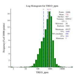
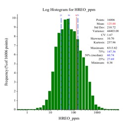
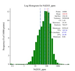
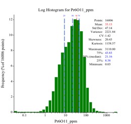
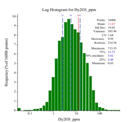
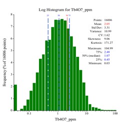
Note: Figure prepared by McGarry Consulting, 2025.
Date: 31 October 2025 |
|
Page 11-7 |
|
|
|
Alpha Project Bahia, Brazil Technical Report Summary |
REO grades are positively correlated (Table 11‑6). Except for cerium, the light rare earths are correlated with coefficients typically above 0.9. Except for europium, the heavy rare earths are strongly correlated with coefficients approaching 1.0.
Table 11‑6: Correlation Matrix, Rare Earth Element Assays
Indep/ Dep |
La2O3 |
CeO2 |
Pr6O11 |
Nd2O3 |
Sm2O3 |
Eu2O3 |
Gd2O3 |
Tb4O7 |
Dy2O3 |
Ho2O3 |
Er2O3 |
Tm2O3 |
Yb2O3 |
Lu2O3 |
Y2O3 |
LREO |
HREO |
La2O3 |
1.00 |
0.67 |
0.95 |
0.91 |
0.83 |
0.57 |
0.74 |
0.67 |
0.60 |
0.54 |
0.49 |
0.44 |
0.42 |
0.39 |
0.48 |
0.90 |
0.59 |
CeO2 |
0.67 |
1.00 |
0.62 |
0.57 |
0.49 |
0.21 |
0.39 |
0.33 |
0.27 |
0.22 |
0.19 |
0.16 |
0.15 |
0.13 |
0.18 |
0.92 |
0.26 |
Pr6O11 |
0.95 |
0.62 |
1.00 |
0.99 |
0.94 |
0.70 |
0.85 |
0.79 |
0.73 |
0.66 |
0.60 |
0.56 |
0.54 |
0.51 |
0.58 |
0.88 |
0.70 |
Nd2O3 |
0.91 |
0.57 |
0.99 |
1.00 |
0.97 |
0.77 |
0.90 |
0.84 |
0.78 |
0.72 |
0.67 |
0.63 |
0.60 |
0.57 |
0.64 |
0.84 |
0.76 |
Sm2O3 |
0.83 |
0.49 |
0.94 |
0.97 |
1.00 |
0.85 |
0.95 |
0.92 |
0.88 |
0.82 |
0.77 |
0.74 |
0.71 |
0.68 |
0.74 |
0.76 |
0.85 |
Eu2O3 |
0.57 |
0.21 |
0.70 |
0.77 |
0.85 |
1.00 |
0.87 |
0.85 |
0.83 |
0.79 |
0.76 |
0.73 |
0.72 |
0.69 |
0.73 |
0.47 |
0.81 |
Gd2O3 |
0.74 |
0.39 |
0.85 |
0.90 |
0.95 |
0.87 |
1.00 |
0.98 |
0.96 |
0.93 |
0.89 |
0.86 |
0.84 |
0.81 |
0.87 |
0.66 |
0.94 |
Tb4O7 |
0.67 |
0.33 |
0.79 |
0.84 |
0.92 |
0.85 |
0.98 |
1.00 |
0.99 |
0.96 |
0.94 |
0.91 |
0.89 |
0.87 |
0.92 |
0.59 |
0.97 |
Dy2O3 |
0.60 |
0.27 |
0.73 |
0.78 |
0.88 |
0.83 |
0.96 |
0.99 |
1.00 |
0.99 |
0.98 |
0.96 |
0.94 |
0.92 |
0.96 |
0.52 |
0.99 |
Ho2O3 |
0.54 |
0.22 |
0.66 |
0.72 |
0.82 |
0.79 |
0.93 |
0.96 |
0.99 |
1.00 |
0.99 |
0.98 |
0.97 |
0.95 |
0.98 |
0.46 |
0.99 |
Er2O3 |
0.49 |
0.19 |
0.60 |
0.67 |
0.77 |
0.76 |
0.89 |
0.94 |
0.98 |
0.99 |
1.00 |
0.99 |
0.98 |
0.97 |
0.99 |
0.41 |
0.99 |
Tm2O3 |
0.44 |
0.16 |
0.56 |
0.63 |
0.74 |
0.73 |
0.86 |
0.91 |
0.96 |
0.98 |
0.99 |
1.00 |
0.99 |
0.99 |
0.98 |
0.37 |
0.97 |
Yb2O3 |
0.42 |
0.15 |
0.54 |
0.60 |
0.71 |
0.72 |
0.84 |
0.89 |
0.94 |
0.97 |
0.98 |
0.99 |
1.00 |
0.99 |
0.97 |
0.35 |
0.96 |
Lu2O3 |
0.39 |
0.13 |
0.51 |
0.57 |
0.68 |
0.69 |
0.81 |
0.87 |
0.92 |
0.95 |
0.97 |
0.99 |
0.99 |
1.00 |
0.96 |
0.33 |
0.94 |
Y2O3 |
0.48 |
0.18 |
0.58 |
0.64 |
0.74 |
0.73 |
0.87 |
0.92 |
0.96 |
0.98 |
0.99 |
0.98 |
0.97 |
0.96 |
1.00 |
0.40 |
0.98 |
LREO |
0.90 |
0.92 |
0.88 |
0.84 |
0.76 |
0.47 |
0.66 |
0.59 |
0.52 |
0.46 |
0.41 |
0.37 |
0.35 |
0.33 |
0.40 |
1.00 |
0.50 |
HREO |
0.59 |
0.26 |
0.70 |
0.76 |
0.85 |
0.81 |
0.94 |
0.97 |
0.99 |
0.99 |
0.99 |
0.97 |
0.96 |
0.94 |
0.98 |
0.50 |
1.00 |
Date: 31 October 2025 |
|
Page 11-8 |
|
|
|
Alpha Project Bahia, Brazil Technical Report Summary |
11.5 Geological Models
The base of saprolite and base of the mottled zone were modelled as offset topography surfaces. The base of saprolite was modelled using manually digitized control points. Points representing the base of the deepest mottled zone interval were extracted from drill hole logs and filtered to remove inconsistent and possibly mis-logged intervals. Copies of the topography surface were then offset to align with base of overburden and base of mottled zone points. The resultant wireframes followed the trend of the topography model and have a 50 m2 resolution.
The saprolite geology model was used to control the lower estimate extent. The base of mottled zone was a ceiling. A single mineralization domain is generated for each deposit area.
The base of mottled zone was used to guide a dynamic search during estimation. Model extents were limited by boundary polygons that define the extent of the resource model and tenement boundaries. Continuity of mineralization was limited by erosional incisions, or barren underlying rock types.
11.5.1 Density Assignment
The density values presented in Table 8‑1 were applied to the block model according to the corresponding regolith domains.
11.5.2 Grade Capping/Outlier Restrictions
High-grade assays were not capped but were retained for grade interpolation using a “clamping” method which allows the very high-grade samples to be available for inclusion in the grade interpolation for blocks which are within a nominated distance of the sample. Beyond that nominated distance, a cap was imposed upon the sample so that the capped grade can be used to interpolate blocks beyond the nominated distance.
McGarry Geoconsulting selected a nominated distance equal to the first search pass radius. Beyond this distance, samples were capped to a nominated 95th percentile from the population statistics. The selected approach prevented the extrapolation of extremely high grades over unreasonably large distances whilst retaining them for estimation of local blocks.
11.6 Composites
Compositing was based on the maximum composite length as defined by the dominant sample length of 1 m (Figure 11‑2).
The minimum composite length was set to 0.5 m. Residual intervals <0.5 m were added to the previous composite.
Date: 31 October 2025 |
|
Page 11-9 |
|
|
|
Alpha Project Bahia, Brazil Technical Report Summary |
Samples coded by the regolith deposit domain they fell within were composited to 1 m intervals, a length equal to the dominant drill sample interval.
11.7 Variography
Semi-variogram models were developed for TREO–CeO2 across the Rio Preto, Sapacaia, and Nova Canaã domains. Experimental semi-variograms were generated, transformed, and assessed for anisotropy before being modelled using two nested spherical structures in addition to a nugget effect. Resulting variograms were cross checked against a selection of rare earth oxides, including neodymium, praseodymium, dysprosium, and terbium. Minor adjustments were made where necessary to ensure the semi-variogram models were suitable for estimation of all rare earth oxides and deleterious elements.
The models are characterized by a low nugget effect (10%), indicating limited random short-range variability. The first spherical structure describes grade continuity of approximately 150–200 m, while the second captures longer-range continuity of 300–400 m. Sill values demonstrate that most of the grade variability is explained by these structures.
Figure 11‑2: Log Probability Plot, Sample Lengths
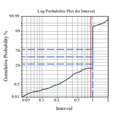
Note: Figure prepared by McGarry Consulting, 2025.
Date: 31 October 2025 |
|
Page 11-10 |
|
|
|
Alpha Project Bahia, Brazil Technical Report Summary |
Directional ranges indicate anisotropy, with greater continuity along the horizontal axes compared to the vertical. This reflects the regolith-hosted nature of the mineralization, where rare earth grades are more continuous laterally than with depth. Overall, the results indicate that grades remain consistent over several hundred meters, with only minor local fluctuations.
11.8 Estimation/interpolation Methods
Mineral resources were estimated using ordinary kriging (OK) into block models created in Leapfrog 2025.1using the Edge Extension. Fifteen rare earth element grades (La, Ce, Pr, Nd, Sm, Eu, Gd, Tb, Dy, Ho, Er, Tm, Yb, Lu and Y) and deleterious elements uranium and thorium were estimated independently in a univariate sense using the same parameters. The consistent estimation approach was selected to ensure block compositional grade proportions honored those of the input samples. The estimation was in a 5 x 5 x 5 discretization of the block and in the parent cell.
Up to three search passes were used if block was not estimated in the first pass. The first search distance was equal to the variogram range; subsequent searches were undertaken using two and four times this distance with successive searches using more relaxed parameters for selection of input composite data. Search parameters are listed in Table 11‑7. Search ranges and clamping restriction settings are provided in Table 11‑8.
Table 11‑7: Search Parameters
|
Pass 1 |
Pass 2 |
Pass 3 |
Search volume multiple |
× 1 |
× 2 |
× 4 |
Minimum samples |
8 |
8 |
8 |
Maximum samples |
15 |
15 |
15 |
Maximum per hole |
4 |
4 |
4 |
Discretization |
5 x 5 x 5 |
||
Boundaries |
Hard |
||
Ellipse segments |
1 |
||
Table 11‑8: Search Ranges and Clamping Restrictions
Domain |
Run |
Ellipsoid Ranges |
Clamping Limit |
||||
Major |
Semi-major |
Minor |
Distance (%) |
Threshold |
|||
Rio Preto |
1 |
400 |
350 |
30 |
— |
— |
|
2 |
800 |
700 |
60 |
50 |
P95 |
||
3 |
1,600 |
1,400 |
400 |
25.00 |
P95 |
||
Sapacaia |
1 |
400 |
350 |
30 |
— |
— |
|
2 |
800 |
700 |
60 |
50 |
P95 |
||
3 |
1,600 |
1,400 |
400 |
25.00 |
P95 |
||
|
1 |
400 |
300 |
30 |
— |
— |
|
Date: 31 October 2025 |
|
Page 11-11 |
|
|
|
Alpha Project Bahia, Brazil Technical Report Summary |
Domain |
Run |
Ellipsoid Ranges |
Clamping Limit |
||||
Major |
Semi-major |
Minor |
Distance (%) |
Threshold |
|||
Nova Canaã |
2 |
800 |
600 |
60 |
50 |
P95 |
|
3 |
1,600 |
1,200 |
400 |
25.00 |
P95 |
||
Rio Das Pombas |
1 |
400 |
400 |
30 |
— |
— |
|
2 |
800 |
800 |
60 |
50 |
P95 |
||
3 |
1,600 |
1,600 |
400 |
25.00 |
P95 |
||
11.9 Validation
Validation of block model grade estimates was completed by:
11.9.1 Visual Validation
For all properties, block grades correlate well with input sample grades. The distribution and tenor of grades in the composites are honored by the block model and are appropriate considering known levels of grade continuity and the semi-variograms.
Total rare earth oxide grades are shown in plan view in Figure 11‑3 and section view in Figure 11‑4.
Date: 31 October 2025 |
|
Page 11-12 |
|
|
|
Alpha Project Bahia, Brazil Technical Report Summary |
Figure 11‑3: Plan View of Largest Block Models Colored by Total Rare Earth Oxide Grade
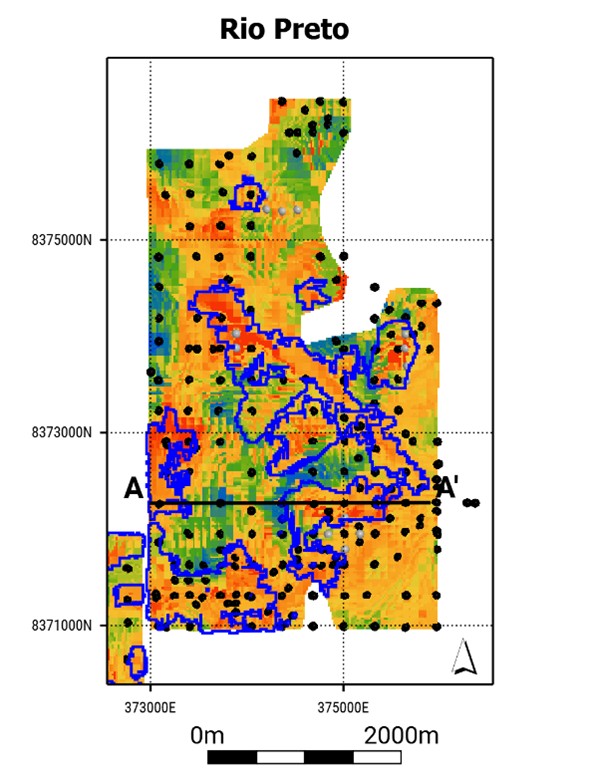
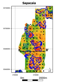
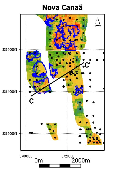
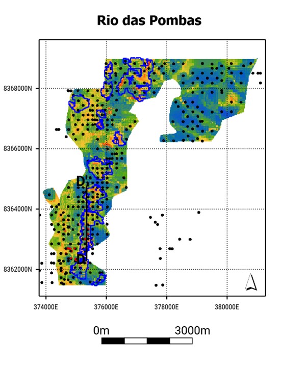
Note: Figure prepared by McGarry Consulting, 2025. Section lines for sections shown in Figure 11‑4 as black lines.
Date: 31 October 2025 |
|
Page 11-13 |
|
|
|
Alpha Project Bahia, Brazil Technical Report Summary |
Figure 11‑4: Cross-Section Views of the Block Model Colored by Total Rare Earth Oxide Grade
|
|
|
|
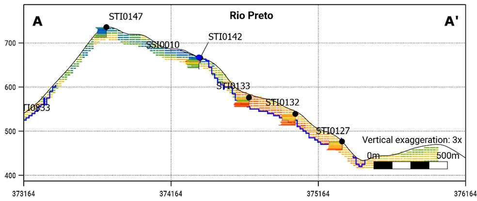
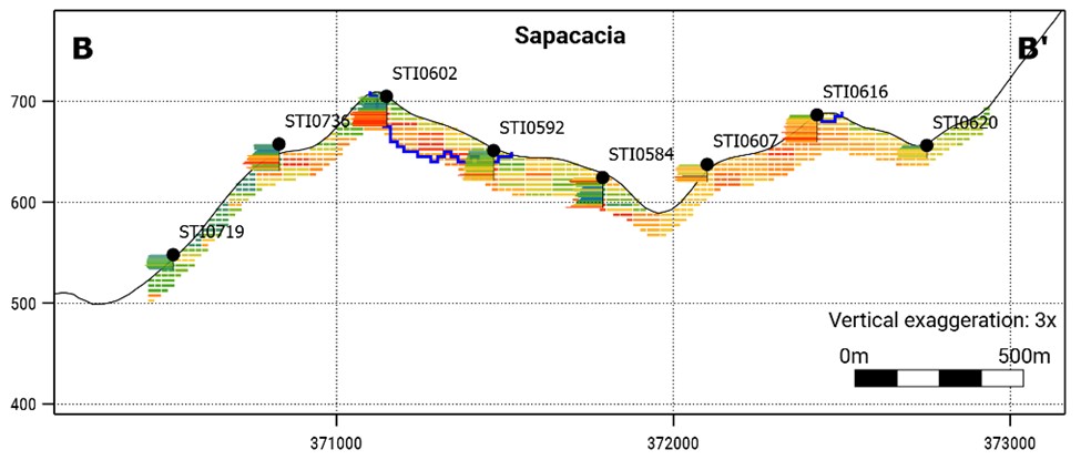
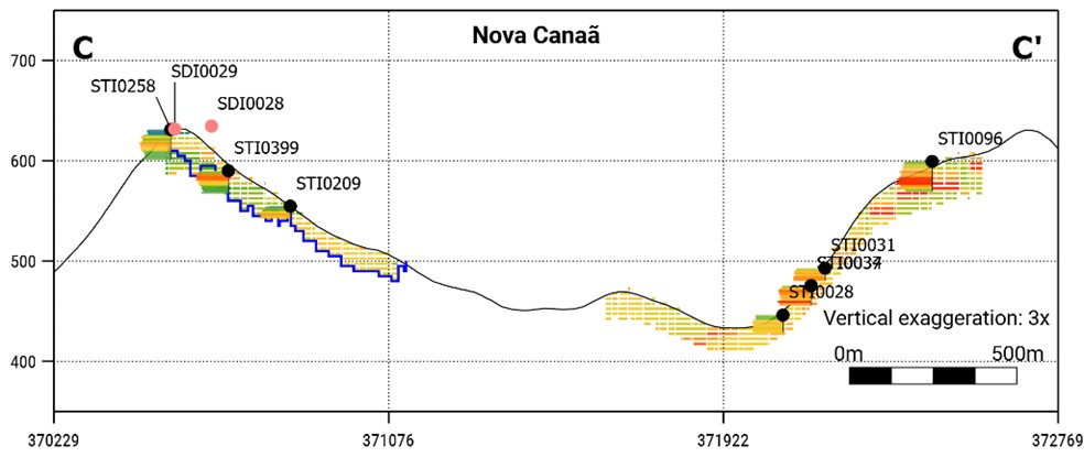
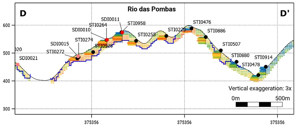
Note: Figure prepared by McGarry Consulting, 2025. Section lines for sections shown in Figure 11‑3 as black lines.
Date: 31 October 2025 |
|
Page 11-14 |
|
|
|
Alpha Project Bahia, Brazil Technical Report Summary |
11.9.2 Comparison of Means
A check was conducted to test that the mean of the input data was close to the block model mean. The check compared the average rare earth oxide input composites and model blocks assigned to each resource estimate domain. For light rare earth oxides, thorium and uranium, which tend to have skewed distributions, block model averages are lower than input samples. For heavy rare earth oxides, which tend to increase with depth to the base of the drill hole, block model grades tend to be slightly higher than the input composites. A summary tabulation of average input and block grades for estimation domain is presented in Table 11‑9.
Differences between input composite and block model grades are typically within ±5% for neodymium, praseodymium, dysprosium and terbium. Larger differences are seen for domains with greater grade variance, and/or fewer samples such as the Nova Canaã domain. The test demonstrated that the mean input composites grade and the grade of both the ordinary kriged and inverse distance weighting to the third power block models are comparable.
Table 11‑9: Comparison of Means for Rio Preto and Sapacaia Domains
Variable |
Comp Mean |
OK Est |
Diff. OK |
Comp Mean |
OK Est |
Diff. OK |
Comp Mean |
OK Est |
Diff. OK |
Rio Preto and Sapacaia Domains |
Nova Canaã |
Rio das Pombas |
|||||||
La2O3 (ppm) |
207.2 |
247 |
19 |
204.4 |
197 |
-3 |
148 |
142 |
-4 |
CeO2 (ppm) |
447.0 |
416 |
-7 |
383.7 |
351 |
-8 |
315 |
277 |
-12 |
Pr6O11 (ppm) |
41.6 |
40.3 |
-3 |
41.1 |
37.6 |
-8 |
30.0 |
28.8 |
-4 |
Nd2O3 (ppm) |
136.1 |
133.4 |
-2 |
136.4 |
127.2 |
-7 |
98.5 |
97.0 |
-1 |
Sm2O3 (ppm) |
22.6 |
22.6 |
0 |
22.5 |
21.2 |
-6 |
16.1 |
15.9 |
-1 |
Eu2O3 (ppm) |
3.0 |
3.2 |
6 |
3.3 |
3.1 |
-6 |
2.2 |
2.4 |
10 |
Gd2O3 (ppm) |
17.8 |
18.2 |
2 |
20.3 |
20.1 |
-1 |
13.1 |
13.5 |
3 |
Tb4O7 (ppm) |
2.6 |
2.6 |
3 |
2.7 |
2.7 |
0 |
1.8 |
1.9 |
3 |
Dy2O3 (ppm) |
14.2 |
14.6 |
3 |
15.1 |
15.3 |
1 |
10.4 |
10.8 |
3 |
Ho2O3 (ppm) |
2.7 |
2.8 |
5 |
2.9 |
3.0 |
3 |
2.0 |
2.1 |
3 |
Er2O3 (ppm) |
7.3 |
7.7 |
5 |
8.2 |
8.5 |
4 |
5.6 |
5.8 |
3 |
Tm2O3 (ppm) |
1.0 |
1.1 |
5 |
1.1 |
1.2 |
4 |
0.8 |
0.8 |
3 |
Yb2O3 (ppm) |
6.6 |
6.9 |
4 |
7.4 |
7.7 |
4 |
5.1 |
5.2 |
2 |
Lu2O3 (ppm) |
0.9 |
1.0 |
4 |
1.0 |
1.1 |
3 |
0.7 |
0.7 |
1 |
Y2O3 (ppm) |
71.3 |
75.1 |
5 |
83.3 |
86.9 |
4 |
56.0 |
58.6 |
5 |
ThO2 (ppm) |
93.3 |
80.3 |
-14 |
77.1 |
66.8 |
-13 |
53.9 |
49.0 |
-9 |
U3O8 (ppm) |
13.7 |
12.4 |
-9 |
12.5 |
10.7 |
-15 |
6.7 |
6.2 |
-8 |
Date: 31 October 2025 |
|
Page 11-15 |
|
|
|
Alpha Project Bahia, Brazil Technical Report Summary |
11.9.3 Swath Plots
Swath plots were generated for the for major domains that account for the majority of resources each property. Swath plots compare the grades of composites and grade estimates that fall within 80m northing and easting slices and 5 m elevation slices. Plots identify slices that contain high-grade samples and low-grade blocks, or vice versa, which might indicate a problem with the estimation technique. Example swath plots for neodymium are shown in Figure 11‑5, Figure 11‑6, and Figure 11‑7.
For all domains, block grades estimated by ordinary kriging and inverse distance weighting to the third power have a smoother profile relative to input samples. Where there are more samples, good agreement is seen between the trends of input composites and block grades estimated by each technique. The ordinary kriged profile is slightly smoother than that generated from the inverse distance weighting to the third power estimate. Both models reflect drill hole data on a local basis.
Figure 11‑5: Swath Plots Rio Preto and Sapacaia Composite Nd2O3 Values Vs. ID3 and OK Estimates
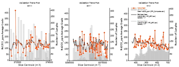
Note: Figure prepared by McGarry Consulting, 2025. OK=ordinary kriged, ID3=inverse distance weighting to the third power.
Date: 31 October 2025 |
|
Page 11-16 |
|
|
|
Alpha Project Bahia, Brazil Technical Report Summary |
Figure 11‑6: Swath Plots Nova Canaã Composite Nd2O3 Values Vs. ID3 and OK Estimates
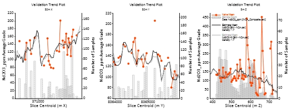
Note: Figure prepared by McGarry Consulting, 2025. OK=ordinary kriged, ID3=inverse distance weighting to the third power.
Figure 11‑7: Swath Plots Rio das Pombas Composite Nd2O3 Values Vs. ID3 and OK Estimates
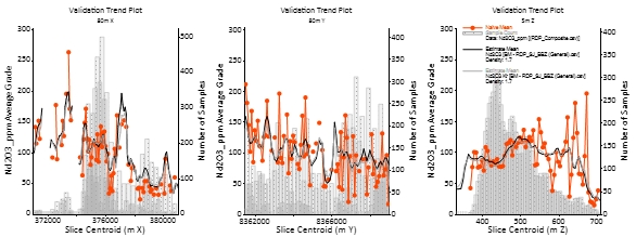
Note: Figure prepared by McGarry Consulting, 2025. OK=ordinary kriged, ID3=inverse distance weighting to the third power.
11.10 Confidence Classification of Mineral Resource Estimate
11.10.1 Mineral Resource Confidence Classification
The Mineral Resource has been classified in accordance with definitions specified in SEC Regulation S-K 1300. The classification level is primarily based upon an assessment of the validity and robustness of input data and the estimator’s judgment with respect to the proximity of resource blocks to sample locations and confidence with respect to the geological continuity of the saprolite horizons and grade
Date: 31 October 2025 |
|
Page 11-17 |
|
|
|
Alpha Project Bahia, Brazil Technical Report Summary |
estimates, quality control results, search and interpolation parameters and an analysis of available density information.
All mineral resources were classified as inferred. The inferred classification is based on the sources of uncertainty tabulated in Table 11‑10 and considers the following key attributes.
Table 11‑10. Sources of Mineral Resource Uncertainty
Uncertainty Source |
Discussion |
Drilling techniques, drill sample recovery. |
Auger, sonic and diamond drilling yield representative samples, with high core recovery supporting the reliability of the resulting assay values for resource estimation at an Inferred level. Augering is the principal drilling method, accounting for 95% of holes drilled and 92% of meters drilled. Auger holes do not recover undisturbed samples of in-situ material preventing high resolution analysis of regolith strata, or in-situ bulk densities. |
Location of data points |
Collar surveys obtained from handheld GPS devices are available for all drilling. Topographic control is provided by low resolution shuttle radar topography. Survey data allow modelling of saprolite intercepts with moderate degree of spatial accuracy congruent with the Inferred classification. |
Data spacing and distribution |
Deposits are well understood based on extensive auger and sonic drilling at spacings sufficient to provide multiple points of observation to interpret saprolite and grade continuity at an Inferred level where drill density is greater than 320 x 320 m. The wide data spacing means the continuity of REE mineralization between holes is assumed rather than confirmed. Auger holes have limited depth penetration and drill holes typically provide only a partial profile of the regolith mineralization. |
Geological modelling |
Geological models are underpinned by a good understanding of the deposit geology. Mineral resources are controlled by the presence of REE-enriched saprolite, and the extent overlying leached mottled zone horizons. Where drill data is sparse alternative interpretations of the continuity of individual regolith units between holes could be made. Alternate interpretations would adjust tonnage estimates locally but would not likely yield a more geologically reasonable result overall. Auger holes have limited depth penetration and drill holes typically provide only a partial profile of mineralized saprolite at the project. Therefore, the total mineralized saprolite depth is uncertain and is predominantly based on widely spaced sonic drilling, where available. |
Minerology |
Rare Earth Americas has not undertaken a comprehensive program of minerology or granulometry, or other geo-metallurgical testwork to determine the presence of rare earth minerals that may be contributing to head grades but that cannot be effectively recovered by leaching. |
Date: 31 October 2025 |
|
Page 11-18 |
|
|
|
Alpha Project Bahia, Brazil Technical Report Summary |
Uncertainty Source |
Discussion |
Estimation |
Rare earth grade estimation and modelling techniques are classified as robust after consideration of the validation exercises undertaken as part of this study. Grade data have distributions with limited skew, and few extreme values, allowing established linear estimation techniques to be used. Estimated block grades reflect input samples and are comparable when calculated by OK methods. At the current typical data spacing (i.e., 320 m to 180 m), saprolite horizon is broadly continuous. Rare earth grades changes are generally gradational down hole and between holes. Grades were estimated using domain scale anisotropy models with appropriately large parent block sizes. Abrupt grade changes associated with more leached or enriched horizons in the regolith profile could be resolved better using smaller block sizes. Estimated in situ dry bulk densities were assigned to saprolite and waste rocks on a weathering domain basis using representative averages obtained from bulk density determinations derived from undisturbed samples from widely spaced sonic and auger drill holes. |
Leach recovery |
High-density meter by meter leach test data enables detailed mapping of recovery variability and supports interpolation into the block model, providing an early indication of recoverable REEs and informing preliminary resource classification. Where leach tests are sparse the resource has a much greater degree of uncertainty. Bench-scale leach tests may not reflect recovery under operational conditions due to differences in reagent distribution, clay permeability, and leach kinetics, introducing uncertainty in process performance and recovery estimates that limit resource classification to the Inferred category. |
Note: REE = rare earth element(s)
Distance between drill holes and inferred mineral resource blocks is shown in Figure 11‑8, for each deposit 75% of the inferred blocks are within 170 m of the nearest drill hole, which is equal to less than 50% of the modelled grade continuity ranges in modelled semi-variograms (refer to Section 11.7). All inferred blocks are within 300 m of the nearest drill hole.
Date: 31 October 2025 |
|
Page 11-19 |
|
|
|
Alpha Project Bahia, Brazil Technical Report Summary |
Figure 11‑8: Classified Block Distances from Drill Hole
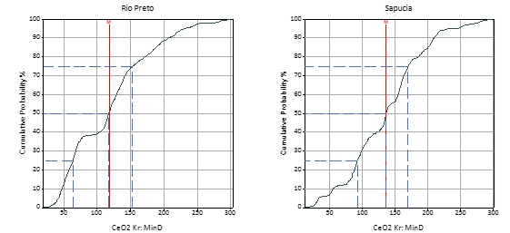
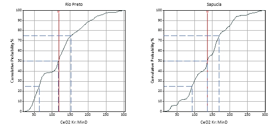
Note: Figure prepared by McGarry Consulting, 2025.
11.11 Reasonable Prospects of Economic Extraction
11.11.1 Initial Assessment Assumptions
To meet the content requirements of an initial assessment to support mineral resource estimates, McGarry Geoconsulting evaluated the content requirements set out in Table 1 of §229.1302 (Item 1302) “Qualified person, technical report summary, and technical studies”.
Date: 31 October 2025 |
|
Page 11-20 |
|
|
|
Alpha Project Bahia, Brazil Technical Report Summary |
The assumptions used in support of the Initial Assessment are summarized in Table 11‑11.
Table 11‑11: Initial Assessment Assumptions
Factors |
Initial Assessment |
Project |
Site infrastructure |
Establish whether or not access to power and site is possible. Assume infrastructure location, plant area required, type of power supply, site access roads, and camp/town site, if required. |
Deposits are located in close proximity to electrical power infrastructure that is already in place feeding power to nearby residents and property owners. Major (500 kV) transmission lines run within close proximity (<20 km) of all deposit areas supplying predominantly clean hydropower. Road access is similar with a short 2.5 km connection required to be built by the project to access the wider road network. Water will be sourced from several nearby storage facilities with short pipelines required to supply the process plant site. It is assumed that the process plant will occupy an area of 0.5–1 km2. |
Mine design & planning |
Mining method defined broadly as surface or underground. Production rates assumed. |
Mineral resources at the project can be mined by conventional truck and shovel arrangement on a free dig basis, much like what is seen in other clay hosted REE and lateritic deposits. Mining costs were obtained from recently disclosed values obtained by peers at comparable projects. |
Processing plant |
Establish that all products used in assessing prospects of economic extraction can be processed with methods consistent with each other. Processing method and plant throughput assumed. |
Leaching testwork by Rare Earth Americas has confirmed that REE-bearing materials across the Poços de Caldas region can be processed using a common, ambient-temperature leaching method under mildly acidic conditions. This flowsheet will include impurity removal and rare earth carbonate precipitation. A modular processing plant is assumed, with 500,000 tpa nominal throughput and dry-stack tailings. All material types under consideration are assumed compatible with this single flowsheet. The plant footprint is estimated at 0.5 to 1.0 km², located outside the current resource shell, within the Pio Cipó mining permit or on adjacent exploration concessions. The site is accessible, gently sloping, and lies 0.5 to 1.5 km from the main resource areas, allowing efficient haulage of run-of-mine feed. These assumptions will be refined as further metallurgical, engineering, and environmental studies are completed. |
Date: 31 October 2025 |
|
Page 11-21 |
|
|
|
Alpha Project Bahia, Brazil Technical Report Summary |
Factors |
Initial Assessment |
Project |
Environmental compliance & permitting |
List of required permits & agencies drawn. Determine if significant obstacles exist to obtaining permits. Identify pre- mining land uses. Assess requirements for baseline studies. Assume post-mining land uses. Assume tailings disposal, reclamation, and mitigation plans. |
The Project is assumed to lie primarily within rural, privately held land used for grazing and agriculture, with no immediate presence of Indigenous lands. Mining is permissible in areas of native vegetation and Atlantic Forest, though compensation and swap arrangements requiring Rare Earth Americas to protect and conserve equivalent vegetation elsewhere. All potential mining activities will be subject to federal, state, and municipal environmental licensing procedures. Project development will require a full Environmental Impact Assessment (EIA/RIMA), with baseline studies initiated at least 12 months prior to submission of a Preliminary License application. Tailings and waste will be managed through dry-stacked or lined containment, with long-term reclamation and groundwater monitoring plans assumed. Part of the Project is within the Serra do Ouro Environmental Protection Area, where potentially polluting activities such as mining are allowed under sustainable use but require licensing approval from the Serra do Ouro Management Authority and compliance with its Management Plan. No fatal flaws are presently identified in the licensing pathway. Federal Agencies and Permits • ANM – Agência Nacional de Mineração ▪ Mineral exploration and mining rights (Alvará de Pesquisa, Requerimento de Lavra). ▪ Approval of Mining Plan (Plano de Aproveitamento Econômico – PAE). ▪ Annual Mining Report (RAL – Relatório Anual de Lavra). • IBAMA – Instituto Brasileiro do Meio Ambiente e dos Recursos Naturais Renováveis ▪ Only leads environmental licensing if the project affects multiple states or federal conservation units. ▪ Issues federal-level Preliminary License (LP), Installation License (LI), and Operation License (LO) when applicable. • CNEN – Comissão Nacional de Energia Nuclear ▪ Authorisation to handle radioactive materials (e.g., monazite with thorium/uranium). ▪ Licensing of storage, packaging, and disposal of radioactive waste. State Agencies (Minas Gerais) and Permits |
Date: 31 October 2025 |
|
Page 11-22 |
|
|
|
Alpha Project Bahia, Brazil Technical Report Summary |
Factors |
Initial Assessment |
Project |
|
|
• INEMA – Instituto do Meio Ambiente e Recursos Hídricos da Bahia. o Lead agency for environmental licensing in Bahia. ▪ Licença Prévia (LP) – Preliminary License. ▪ Licença de Instalação (LI) – Installation License. ▪ Licença de Operação (LO) – Operation License. o Oversees the Environmental Impact Study and Report (EIA/RIMA). o Coordinates public consultation (audiência pública). o Autorização de Supressão de Vegetação (ASV) – Vegetation clearance permit. o Oversees reforestation and biodiversity compensation obligations. • SEMA – Secretaria do Meio Ambiente do Estado da Bahia o Formulates environmental policy; may participate in strategic project reviews. • SRH – Superintendência de Recursos Hídricos o Grants water use rights and evaluates hydrological and aquifer impact studies. |
Other relevant factors |
Appropriate assessments of other reasonably assumed technical and economic factors necessary to demonstrate reasonable prospects for economic extraction. |
None |
Capital costs |
Optional. If included: |
Not relevant to this Report. |
Operating costs |
Optional. If included: Accuracy: ±50% Contingency: ≤25% |
Not relevant to this Report. |
Economic analysis |
Optional. If included: Taxes and revenues are assumed. Discounted cash flow analysis based on assumed production rates and revenues from available measured and indicated mineral resources. |
Not relevant to this Report. |
Note: REE = rare earth element(s)
Date: 31 October 2025 |
|
Page 11-23 |
|
|
|
Alpha Project Bahia, Brazil Technical Report Summary |
11.11.2 Constraining Potentially Mineable Shape Input Assumptions
Following input assumptions were applied to determine reasonable prospects for economic extraction:
11.11.3 Market and Commodity Price Forecasts
General Uses and Products
The mineral resource estimate contains potentially minable concentrations of rare earth elements including MREO neodymium, praseodymium, dysprosium and terbium, which represent the dominant contributors to the in-situ value calculations and are the primary drivers of the Project’s economic potential.
These elements are predominantly used in the manufacture of permanent magnets, which are essential for advanced technologies such as electric vehicles, wind turbines, electronics, robotics, and a wide range of consumer, industrial, and defence electronics applications. Though used in small quantities, they provide critical magnetic, optical, and catalytic properties.
The most likely commercial products from the Alpha Project are mixed rare earth carbonates (MREC), an intermediate product used in the manufacture of refined, separated, rare earth oxides, predominantly for the permanent magnet market.
Date: 31 October 2025 |
|
Page 11-24 |
|
|
|
Alpha Project Bahia, Brazil Technical Report Summary |
Market Overview and Principal Users
Global magnetic rare earth oxide demand in 2024 was 126,025 tonnes. Global MREO demand is being forecasted to grow at an 8.2% compound annual growth rate (CAGR), total demand is forecast at 444,872 tonnes by (Adamas Intelligence, 2024).
Figure 11‑9: Forecast Global NdPr Oxide Production and Demand
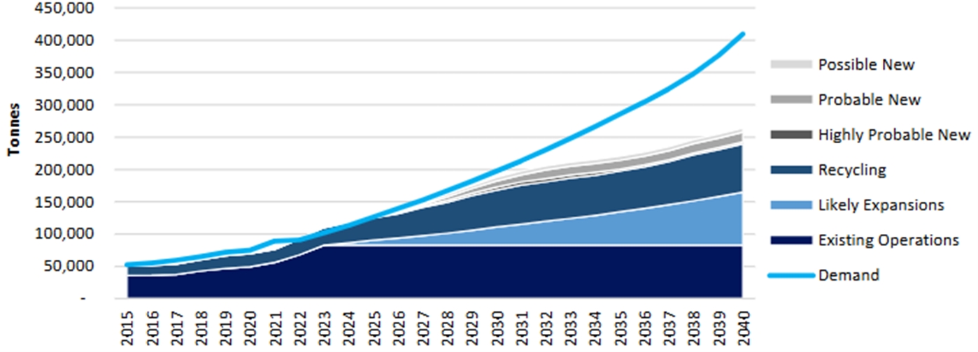
Note: Source Adamas Intelligence (2024)
Figure 11‑10: Forecast Global Dysprosium Oxide Production and Demand
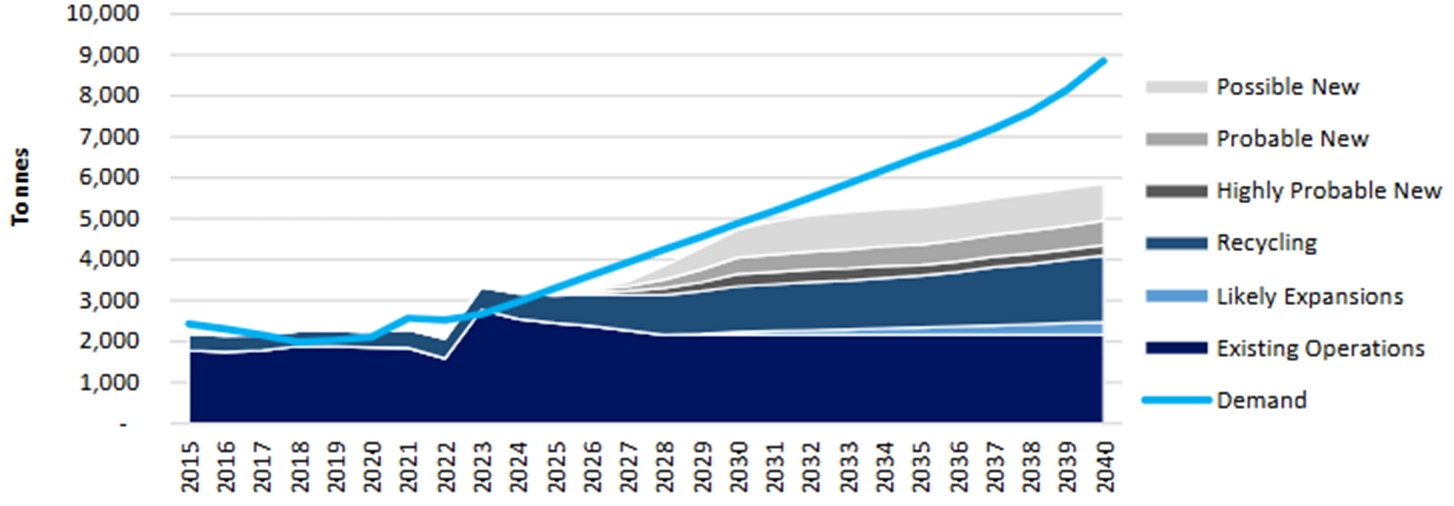
Note: Source Adamas Intelligence (2024)
Date: 31 October 2025 |
|
Page 11-25 |
|
|
|
Alpha Project Bahia, Brazil Technical Report Summary |
The principal consumers are Chinese, Japanese, South Korean, European, and North American manufacturers of permanent magnets for the automotive and renewable energy sectors.
China accounts for ~65% of global rare earth production and >80% of processing, though its share of global NdPr mined supply is forecast to decline from 70% in 2024 to ~58% by 2029 (Benchmark Mineral Intelligence, 2024). Supply remains geographically constrained, and recent Chinese restrictions on technology exports highlight ongoing volatility and the strategic importance of new projects outside of China.
Brazil is projected to expand its role in the rare earth market, with ionic clay deposits, including Serra Verde (operating) and emerging projects (such as Alpha) expected to increase Brazil’s share of dysprosium supply with Benchmark Mineral Intelligence (2024) predicting an increase from 2% share in 2024 to ~11% share by 2029.
Marketability and Pricing
The Project is expected to produce a mixed rare earth carbonate. These oxides are specialty chemicals, not exchange-traded commodities, and are typically priced in US dollars per kilogram. Pricing is negotiated through private contracts and the contract negotiated typically reflects product purity, oxide composition, delivery terms, and prevailing demand.
Due to the lack of standardized markets, pricing remains opaque. However, indicative spot prices are published by agencies such as Asian Metal and Shanghai Metals Market and are widely used for valuation purposes.
Price Forecasts
The expected increase in demand, and high price volatility, means that commodity pricing for rare earth studies is predominantly based on forecasts made by expert research companies such as Adamas Intelligence.
Rare Earth Americas have used the average rare earth oxide price over a 10-year period to from 2031 to 2040 forecast by Adamas Intelligence in their Q1 2025 Rare Earth Pricing Quarterly Outlook. This period was selected to align with potential timeframes for construction of all infrastructure and mining of the deposit. Prices include 13% value-added tax (VAT); forecast prices are in Real 2025 USD dollars. These VAT-inclusive prices are presented for consistency with published Chinese market indices and have not been adjusted.
Example forecasts for the 2030–2040 period (real 2025 dollars, inclusive of 13% VAT) are given in Table 11‑12. Prices are expected to remain relatively stable through the mid-2020s before increasing in the early 2030s as supply constraints emerge, then stabilizing at the long-term incentive levels used for this study (Adamas Intelligence, 2024).
Date: 31 October 2025 |
|
Page 11-26 |
|
|
|
Alpha Project Bahia, Brazil Technical Report Summary |
Table 11‑12: Rare-Earth Elements Prices and Average Basket Price Calculation
REE Oxide1 |
Avg. Proportion of Recovered TREO (%) |
Forecast Price |
Value at 70% Payability ($/kg) |
Contribution to Avg. Basket Value ($/kg)3 |
Proportion of Avg. Basket Value(%) |
||
La2O3 |
24.3 |
1.4 |
1.0 |
0.2 |
0.4 |
||
CeO2 |
6.7 |
1.5 |
1.0 |
0.1 |
0.1 |
||
Pr6O11 |
6.3 |
158.6 |
111.0 |
7.0 |
12.2 |
||
Nd2O3 |
24.3 |
154.8 |
108.3 |
26.3 |
46.0 |
||
Sm2O3 |
4.3 |
4.3 |
3.0 |
0.1 |
0.2 |
||
Eu2O3 |
0.6 |
34.7 |
24.3 |
0.1 |
0.3 |
||
Gd2O3 |
3.7 |
80.5 |
56.3 |
2.1 |
3.6 |
||
Tb4O7 |
0.5 |
1550.8 |
1085.5 |
5.8 |
10.1 |
||
Dy2O3 |
3.2 |
503.5 |
352.5 |
11.4 |
19.8 |
||
Ho2O3 |
0.6 |
171.2 |
119.8 |
0.7 |
1.2 |
||
Er2O3 |
1.8 |
58.0 |
40.6 |
0.7 |
1.3 |
||
Yb2O3 |
21.9 |
8.0 |
5.6 |
1.2 |
2.1 |
||
Lu2O3 |
1.3 |
17.5 |
12.3 |
0.2 |
0.3 |
||
Y2O3 |
0.2 |
910.8 |
637.6 |
1.3 |
2.2 |
||
Average TREO Basket Value $/kg: |
57.2 |
100.0 |
|||||
Notes:
Payability
Payability represents the proportion of contained rare earth element value (based on spot oxide prices) that is realized upon sale of the mixed rare earth carbonate. It depends on the concentration of high-value elements, total rare earth oxide grade, impurity levels, and offtake processing costs. Rare Earth Americas intends to produce a high-quality mixed rare earth carbonate with low impurities and elevated magnet rare earth elements. This study assumes a payability of 70 percent relative to the spot value of contained separated oxides.
Basket Value Estimation
For each block, a “basket value” is calculated as the sum of the forecast prices for individual recovered rare earth oxides, adjusted by their typical proportion in the recovered TREO mix and a payability assumption of 70%. The average basket price is estimated at US$57.2 per kilogram of recovered TREO.
Date: 31 October 2025 |
|
Page 11-27 |
|
|
|
Alpha Project Bahia, Brazil Technical Report Summary |
The basket value is determined using the following formula:
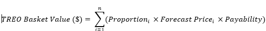
Proportion = Typical proportion of recovered oxide i in the recovered TREO mix
Forecast Price𝑖 = Forecast price per kg of oxide i
Payability = Payability rate of 70%
This block-level basket value serves as an input into a Lerchs–Grossmann optimization process, which was used to define a resource-constraining shell for mineral resource reporting and evaluation of reasonable prospects of economic extraction.
11.11.4 Pit Shell
To demonstrate reasonable prospects for eventual economic extraction a conceptual constraining pit shell was constructed using block models created for each deposit including Inferred category mineral resource and waste block.
The constraining shell is derived from a Whittle optimization using estimated block value and mining parameters appropriate for determining reasonable prospects of economic extraction. These include a mining cost of US$1.98/t, a processing cost of US$9.39/t, appropriate recovery and dilution factors, and the basket value estimated for each block. A maximum pit slope angle of 35° was used and the extent of the constraining pit shell was limited to within the boundary of each tenement. A summary of the key assumptions is shown in Table 11‑13.
Table 11‑13: Whittle Resource Constraining Pit Shell Parameters
Item |
Notation |
Unit |
Value |
Average recovered value |
(P) |
$/t |
57.2 |
Mining cost (mineralization and waste) |
(m) |
$/t |
1.98 |
Process cost |
(C) |
$/t |
7.65 |
General and administrative cost |
(CGA) |
$/t |
1.74 |
Dilution |
(d) |
% |
0 |
Mining recovery |
(ym) |
% |
95 |
Average process recovery |
(yc) |
% |
27 |
Recovered cut-off grade |
(Grec) |
ppm TREO |
209 |
In-situ cut-off grade |
(Ginsitu) |
ppm TREO |
774 |
Selected in-situ cut-off grade |
|
ppm TREO |
1,000 |
Date: 31 October 2025 |
|
Page 11-28 |
|
|
|
Alpha Project Bahia, Brazil Technical Report Summary |
The overall strip ratio is estimated at 0.55, indicating that each tonne of mineralization is accompanied by 0.55 t of waste. Areas excluded include zones with low estimated recovery of rare earths, as well as speculative blocks at depth and at the periphery of the deposits.
For each deposit area, pit shell extents at surface are shown in Figure 11‑3, and in cross-section in Figure 11‑4. Material falling outside of the pit shell is considered to not meet reasonable prospects for economic extraction. Potentially minable portions of the block model inside the shell are conceptual in nature. Potential royalty costs have not been included in the Whittle optimization calculation.
11.11.5 Cut-off
Using the parameters in Table 11‑13, a marginal reporting cut-off of 1,000 ppm TREO was selected. This threshold is consistent with cut-off grades applied at comparable ionic clay-hosted rare earth deposits developed by open-pit mining and supports a reasonable expectation of economic extraction.
The following equations form the basis of the cut-off calculation:
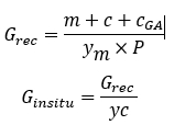
Abbreviations used in these equations are explained in Table 11‑13.
The cut-off is based on the average recovered value using a 10-year forecast of rare earth oxide prices to 2040, as published by Adamas Intelligence in the Q1 2025 Rare Earth Pricing Quarterly Outlook. The marginal cut-off includes mining, processing, and general and administrative costs. Costs related to waste mining, transportation, capital expenditures, and royalties are excluded.
11.11.6 QP Statement
Based on the data review, the attendant work done to verify the data integrity and the creation of an independent geologic model, McGarry Geoconsulting believes this is a fair and accurate representation of the mineral resources at the Project.
There is sufficient time in the 10-year timeframe considered for the commodity price forecast for Rare Earths Americas to address any issues that may arise, or perform appropriate additional drilling, testwork and engineering studies to mitigate identified issues with the estimates.
Date: 31 October 2025 |
|
Page 11-29 |
|
|
|
Alpha Project Bahia, Brazil Technical Report Summary |
Based on the current information, McGarry Geoconsulting considers that the mineral resource estimates have reasonable prospects for eventual economic extraction, subject to the successful completion of the recommended work programs.
11.12 Mineral Resource Statement
Mineral resources are reported using the mineral resource definitions set out in SK1300. The reference point for the estimate is in situ. The estimate is current as at 31 October 2025.
The third-party firm responsible for the estimate is McGarry Geoconsulting, Corp.
Mineral Resources are summarized in Table 11‑14.
Table 11‑14: Alpha Project Mineral Resource Estimate
Category |
Cut-Off Grade |
Deposit |
Tonnes |
TREO |
Nd2O3 + Pr6O11 |
Dy2O3 + Tb4O7 |
|
(ppm TREO) |
|
(Mt) |
(ppm) |
(ppm) |
(ppm) |
Inferred |
1,000 |
Rio Preto |
80.8 |
1,478 |
327 |
41.1 |
Sapacaia |
50.6 |
1,846 |
356 |
33.9 |
||
Rio das Pombas |
56.5 |
1,370 |
298 |
40.0 |
||
Nova Canaã |
13.8 |
1,184 |
260 |
34.4 |
||
Total |
201.7 |
1,520 |
322 |
38.5 |
Notes to accompany mineral resource table:
Date: 31 October 2025 |
|
Page 11-30 |
|
|
|
Alpha Project Bahia, Brazil Technical Report Summary |
11.13 Uncertainties (Factors) That May Affect the Mineral Resource Estimate
Factors which may affect the mineral resource estimates include the following.
In the opinion of the Qualified Person, all material issues relating to the relevant technical and economic factors that may influence the prospect of eventual economic extraction at the Project can reasonably be resolved with further work. While certain factors, such as leaching performance at bulk sample scale, the quality of a potential mixed rare earth carbonate product, the geotechnical characterization of proposed infrastructure sites, and the permitting framework, require additional data and assessment, none are currently identified as fatal flaws.
Date: 31 October 2025 |
|
Page 11-31 |
|
|
|
Alpha Project Bahia, Brazil Technical Report Summary |
12.0 MINERAL RESERVE ESTIMATES
This Chapter is not relevant to this Report.
Date: 31 October 2025 |
|
Page 12-1 |
|
|
|
Alpha Project Bahia, Brazil Technical Report Summary |
13.0 MINING METHODS
This Chapter is not relevant to this Report.
Date: 31 October 2025 |
|
Page 13-1 |
|
|
|
Alpha Project Bahia, Brazil Technical Report Summary |
14.0 RECOVERY METHODS
This Chapter is not relevant to this Report.
Date: 31 October 2025 |
|
Page 14-1 |
|
|
|
Alpha Project Bahia, Brazil Technical Report Summary |
15.0 INFRASTRUCTURE
This Chapter is not relevant to this Report.
Date: 31 October 2025 |
|
Page 15-1 |
|
|
|
Alpha Project Bahia, Brazil Technical Report Summary |
16.0 MARKET STUDIES AND CONTRACTS
This Chapter is not relevant to this Report.
Date: 31 October 2025 |
|
Page 16-1 |
|
|
|
Alpha Project Bahia, Brazil Technical Report Summary |
17.0 ENVIRONMENTAL STUDIES, PERMITTING, AND PLANS, NEGOTIATIONS, OR AGREEMENTS WITH LOCAL INDIVIDUALS OR GROUPS
This Chapter is not relevant to this Report.
Date: 31 October 2025 |
|
Page 17-1 |
|
|
|
Alpha Project Bahia, Brazil Technical Report Summary |
18.0 CAPITAL AND OPERATING COSTS
This Chapter is not relevant to this Report.
Date: 31 October 2025 |
|
Page 18-1 |
|
|
|
Alpha Project Bahia, Brazil Technical Report Summary |
19.0 ECONOMIC ANALYSIS
This Chapter is not relevant to this Report.
Date: 31 October 2025 |
|
Page 19-1 |
|
|
|
Alpha Project Bahia, Brazil Technical Report Summary |
20.0 ADJACENT PROPERTIES
This Chapter is not relevant to this Report.
Date: 31 October 2025 |
|
Page 20-1 |
|
|
|
Alpha Project Bahia, Brazil Technical Report Summary |
21.0 OTHER RELEVANT DATA AND INFORMATION
This Chapter is not relevant to this Report.
Date: 31 October 2025 |
|
Page 21-1 |
|
|
|
Alpha Project Bahia, Brazil Technical Report Summary |
22.0 INTERPRETATION AND CONCLUSIONS
22.1 Introduction
The QPs note the following interpretations and conclusions, based on the review of data and information available for this Report.
22.2 Property Setting
The tenement area ranges in elevation from approximately 400–900 masl. Elevation and relief should be considered in planning ground exploration and drill access; however, terrain conditions are not expected to materially constrain exploration activities at the Project.
The Project is accessible via federal highways (BR-116, BR-101) and local all-weather roads and is in proximity to rail infrastructure and the Port of Ilhéus. The nearby municipality of Iguaí can provide logistical support and services, while Salvador and the nearby Camacari chemical complex can serve as sources of equipment, reagents, and personnel.
The climate in the region supports year-round exploration and mining activities, with only limited seasonal disruption.
22.3 Ownership
The Project is wholly owned by Rare Earths Americas.
22.4 Mineral Tenure, Surface Rights, Water Rights, Royalties and Agreements
Information obtained from legal experts retained by Rare Earth Americas supports that the mineral tenure held is valid, and the mineral tenures held are sufficient to support mineral resource estimation.
To date Rare Earth Americas has secured verbal agreements and signed consent declarations from landowners permitting exploration and drilling activities at the Alpha Project. Rare Earth Americas intends to initiate formal discussions regarding broader surface rights as the Project progresses.
Rare Earth Americas has not obtained any permits or agreements to extract water for exploration at the Alpha Project. Exploration to date has not required water use. Future diamond core drilling may require water, which is expected to be commercially supplied via tankers or obtained under agreement for temporary extraction from local sources.
The Project is not subject to any private royalties but is subject to the CFEM.
Date: 31 October 2025 |
|
Page 22-1 |
|
|
|
Alpha Project Bahia, Brazil Technical Report Summary |
All exploration work undertaken to date, including auger drill pad construction and access road development, has been conducted in accordance with applicable state and local environmental regulations. Rare Earth Americas acknowledges that any future advancement beyond the exploration stage will be subject to additional environmental permitting at both the state and federal levels.
Based on the review of the legal and regulatory setting, the Qualified Person is not aware of any legal, regulatory, or permitting impediments that would prevent the continued exploration and potential development of a mining project.
Acceptance of the Final Exploration Report marks the formal conclusion of the exploration phase. Once accepted, ANM may authorize the initiation of the Mining Concession application process. Authorisation remains pending for all concessions:
Rare Earth Americas have not consulted with local communities during the exploration campaigns. The company’s interactions were limited to rural landowners, solely for the purpose of facilitating access for exploration activities.
To the extent known to McGarry Geoconsulting, there are no other significant factors and risks that may affect access, title, or the right or ability to perform work on the Project that are not discussed in this Report.
22.5 Geology and Mineralization
The Project hosts rare earth element mineralization in the form of ionically adsorbed rare earth elements bound to clay minerals within the regolith developed over the crystalline basement. Although ionic adsorption clay deposits are not currently classified within the United States Geological Survey Mineral Deposit Model series, the deposit type is well defined in the geological literature.
The Project is situated within the Jequié Complex, an Archean-age tectono-structural block comprising rare earth element-enriched granulites, supracrustal sequences, and batholithic intrusions of the Volta do Rio and Poço Preto metaplutonic suites. At the Project, weathering of the crystalline basement has liberated rare earth elements, which occur in the form of ionically adsorbed mineralization within a well-developed weathering profile, consistent with the ionic adsorption clay deposit style.
Date: 31 October 2025 |
|
Page 22-2 |
|
|
|
Alpha Project Bahia, Brazil Technical Report Summary |
The regolith profile, including mottled zones and mineralized saprolite, is laterally continuous across large parts of the deposit area. Drilling has confirmed sufficient geological continuity of mineralized horizons to support the estimation of inferred mineral resources.
However, due to the presence of residual cover and the regolith-dominated profile, the underlying bedrock geology and its control on rare earth element distribution are not yet well understood. Additionally, the current drill spacing is too wide to resolve local variations in regolith thickness or the vertical position of mineralized zones with the confidence required for higher resource classifications.
Further geological work and infill drilling will be necessary to improve confidence in the geological model and to support the estimation of indicated or measured mineral resources.
22.6 History
There is no known previous exploration for rare earth elements in the Project area prior to Rare Earths America’s Project interest. In 2021 Alpha Minerals Brazil Participações Ltd a wholly owned subsidiary of Rare Earth Americas conducted a review of a historical regional-scale airborne geophysical survey flown by the state mineral research agency CBPM. Based on the presence of prospective radiometric anomalies associated, the Project exploration licenses were acquired by Alpha Minerals Brazil Participações Ltd, between 2021 and 2023. Rare Earth Americas was created as the holding company for the Project in January 2023.
22.7 Exploration, Drilling, and Sampling
Exploration and drilling completed to date are appropriate for the regolith-hosted ionic clay rare earth mineralization at the Alpha Project.
Drill collars were surveyed using handheld GPS referenced to SIRGAS 2000 UTM 24S and projected to a 30 m DTM; future programs should use differential GPS and higher-resolution topography to improve accuracy for resource modelling and engineering studies.
Sufficient drilling and sampling data have been collected to support the geological interpretation and mineral resource estimates. Hole spacing ranges from 320 m (with infill drilling on a diamond pattern) to 225 m and 160m in the most densely drilled places. The geology and mineralization controls are well understood, and the exploration techniques and QA/QC protocols employed are appropriate for this deposit style. The rare earth assay and leach recovery datasets are of adequate quality and quantity for resource estimation, with minimal risk to overall confidence.
Rare Earth Americas’ drilling, sampling, assaying, and QA/QC have been completed in line with industry practices.
The current dataset is sufficient to support the mineral resource estimates disclosed. Additional drilling, improved surveying, and further metallurgical testing are recommended to refine the model and advance resources to higher confidence categories.
Date: 31 October 2025 |
|
Page 22-3 |
|
|
|
Alpha Project Bahia, Brazil Technical Report Summary |
22.8 Data Verification
Sufficient exploration and sampling data have been collected to support the geological interpretations and to underpin the rare earth mineral resource estimates. The resource has been classified as inferred, reflecting the current limitations in data spacing, reliance on auger drilling that only partially tests the regolith profile, and low survey and digital elevation model accuracy.
The overall quality of the data acquired by Rare Earth Americas is considered to be acceptable and with improved drilling density and spatial control, the mineral resource has the potential to be upgraded to higher confidence categories in future estimates with the support of additional work programs.
22.9 Metallurgical Testwork
The metallurgical dataset is considered acceptable to support the current inferred mineral resource estimate.
The bench-scale leach tests replicate the proposed ammonium sulphate ion-exchange process and are relevant to the ionic clay deposit style. The systematic sampling captures both lateral and vertical variability in rare earth recovery by leaching.
The recoveries are considered sufficiently representative of bulk-scale behavior to support determine reasonable prospects for eventual economic extraction in accordance with the Inferred classification.
It is recommended that future work include bulk composite and pilot-scale leach testing to evaluate potential comminution effects in transitional horizons, test material handling and leach solution flow, and refine recovery estimates across different regolith domains. Continuous column leach testing should also be undertaken to replicate percolation behavior under process-representative conditions and validate leaching kinetics. These larger-scale tests should provide sufficient pregnant leach solution volumes for confirmatory work on mixed rare earth carbonate precipitation and purification, enabling verification of product quality and recovery through to a saleable product.
These programs should strengthen the metallurgical basis for the mineral resource estimate and support the economic assumptions in sufficient detail to support higher-confidence mineral resource categories and engineering studies.
22.10 Mineral Resource Estimates
An Initial Assessment was completed to support assessments of reasonable prospects for economic extraction. The depth, geometry, and grade of rare earth bearing saprolite on the properties make them amenable to exploitation by open cut mining methods. Mineral resources are reported within a resource constraining conceptual pit shell.
Date: 31 October 2025 |
|
Page 22-4 |
|
|
|
Alpha Project Bahia, Brazil Technical Report Summary |
Mineral resources are reported using the mineral resource definitions set out in SK1300. The in situ mineral resource estimate consists of 201.7 Mt at an average grade of 1,520 ppm TREO at a 1,000 ppm TREO reporting cut-off.
Factors which may affect the mineral resource estimates include the following.
In the opinion of the Qualified Person, all material issues relating to the relevant technical and economic factors that may influence the prospect of eventual economic extraction at the Project can reasonably be resolved with further work. While certain factors, such as leaching performance at bulk sample scale, the quality of a potential mixed rare earth carbonate product, the geotechnical characterization of proposed infrastructure sites, and the permitting framework, require additional data and assessment, none are currently identified as fatal flaws.
22.11 Risks
22.11.1 Exploration and Geology Risks
The following risks were identified:
Date: 31 October 2025 |
|
Page 22-5 |
|
|
|
Alpha Project Bahia, Brazil Technical Report Summary |
22.11.2 Mineral Resource Estimate Risks
The following risks, in addition to those identified in Chapter 22.10, were also identified:
22.11.3 Environmental, Social and Permitting Risks
The following risks were identified:
No fatal flaws have been identified; these risks are typical for a project at this stage and are expected to be addressed through additional drilling, improved surveying, bulk density testing, hydrogeological assessment, permitting studies, expanded metallurgical testwork, and technical and engineering studies.
Date: 31 October 2025 |
|
Page 22-6 |
|
|
|
Alpha Project Bahia, Brazil Technical Report Summary |
22.12 Opportunities
22.12.1 Exploration and Geology Opportunities
The Alpha Project is located in a previously underexplored geological and mining jurisdiction. Rare Earth Americas are building an extensive and well-informed database of information which will provide an opportunity to assess the optimal exploration targeting strategy and exploration potential for the Project.
The recent discovery of rare earth element mineralization by Rare Earth Americas at the Alpha Project has the potential to establish a new and previously unrecognized rare earth element metallogenic province.
As well as ongoing development and resource definition for ionic clay style mineralization, the discovery of high-grade rare earth element materials, indicative of secondary monazite mineralization, suggests there may be strong potential for the discovery of other rare earth mineralization types in regolith and bedrock.
22.12.2 Mineral Resource Opportunities
Opportunities exist to increase existing mineral resources by additional work including infill and extensional drilling at depth.
22.13 Conclusions
Drilling has consistently intersected significant rare earth element-bearing saprolite, frequently exhibiting MREO enrichment with depth. More recent drilling has identified high-grade monazite sand mineralization associated with the Volta do Rio Suite, a geologically prospective unit extending across the Project area.
The data verification programs undertaken on the data collected from the Project support the geological interpretations and the analytical and database quality, and therefore the data can be used for mineral resource estimation.
The metallurgical dataset is considered adequate to support the current mineral resource estimate. The bench-scale leach tests replicate the proposed ammonium sulphate ion-exchange process and are relevant to the ionic clay deposit class. The systematic sampling captures both lateral and vertical variability, and the recoveries allow an inference of bulk-scale behavior at the current resource development stage.
Date: 31 October 2025 |
|
Page 22-7 |
|
|
|
Alpha Project Bahia, Brazil Technical Report Summary |
In the opinion of the Qualified Person, all material issues relating to the relevant technical and economic factors that may influence the prospect of eventual economic extraction at the Project can reasonably be resolved with further work. While certain factors, such as leaching performance at bulk sample scale, the quality of a potential mixed rare earth carbonate product, the geotechnical characterization of proposed infrastructure sites, and the permitting framework, require additional data and assessment, none are currently identified as fatal flaws.
Additional work is warranted, and a two-phase work program is recommended. (see Chapter 23).
Date: 31 October 2025 |
|
Page 22-8 |
|
|
|
Alpha Project Bahia, Brazil Technical Report Summary |
23.0 RECOMMENDATIONS
23.1 Introduction
The Alpha Project hosts rare earth element mineral resource that warrants further exploration and evaluation. A two-phase work program is recommended. Phase A will focus on generating additional exploration data and materials, while Phase B will address targeted testwork and technical analysis.
Phase A aims to improve understanding of the controls on mineralization and to delineate additional prospective zones. Infill drilling and technical studies will be undertaken to potentially upgrade mineral resources from the inferred to higher-confidence mineral resource classifications. Phase A is estimated to require a budget of US$2.58 million to complete.
Results from Phase A exploration will provide representative drill samples for metallurgical testing and will provide a basis for an updated appraisal of the deposits. If results are positive the project will advance to Phase B, which will involve the analysis of key modifying factors, including mining and processing considerations, to updated the Initial Assessment and mineral resource estimates. Phase B is estimated to require a budget of US$1.15 million.
Collectively, Phase A and Phase B will require an overall budget of US$3.73 million.
23.2 Phase A
The following recommendations are made for Phase A:
Date: 31 October 2025 |
|
Page 23-1 |
|
|
|
Alpha Project Bahia, Brazil Technical Report Summary |
Table 23‑1: Budget for Phase A Work Program
Item |
Total Cost (US$) |
Surface exploration and ground geophysics1 |
$250,000 |
Auger drilling - 2,250 m1 |
$1,000,000 |
Core drilling - 8,000 m1 |
$1,250,000 |
High resolution satellite DEM |
$10,000 |
Minerology testwork |
$70,000 |
Total |
$2,580,000 |
Notes:
Program budgets are inclusive of assay, personnel, equipment, consumables and transport costs.
23.3 Phase B
The following recommendations are made for Phase B:
Date: 31 October 2025 |
|
Page 23-2 |
|
|
|
Alpha Project Bahia, Brazil Technical Report Summary |
Table 23‑2: Budget for Phase B Work Program
Item |
Total Cost (US$) |
Metallurgical testwork |
$250,000 |
Mineral Resource estimation |
$100,000 |
Mining studies |
$300,000 |
Infrastructure assessment |
$100,000 |
Environmental, social and permitting assessment |
$400,000 |
Total |
$1,150,000 |
Notes:
Program budgets are inclusive of assay, personnel, equipment, consumables and transport costs.
Date: 31 October 2025 |
|
Page 23-3 |
|
|
|
Alpha Project Bahia, Brazil Technical Report Summary |
24.0 REFERENCES
24.1 Bibliography
Adamas Intelligence (2024). Rare Earth Magnet Market Outlook to 2040. Q3 2024.
Barbosa, J., Martin, H., & Peucat, J. J. (2004). Palaeoproterozoic dome-forming structures related to granulite-facies metamorphism, Jequié block, Bahia, Brazil: petrogenetic approaches. Precambrian Research, 135(1-2), 105-131.
Barbosa, J., Martin, H., & Peucat, J. J. (2004). Palaeoproterozoic dome-forming structures related to granulite-facies metamorphism, Jequié block, Bahia, Brazil: petrogenetic approaches. Precambrian Research, 135(1-2), 105-131.
Benchmark Mineral Intelligence. (2024). Rare Earths Forecast Report, Q4 2024. Benchmark Mineral Intelligence. www.benchmarkminerals.com
CPRM-Serviço Geológico Do Brasil, (2010). Mapa Hidrogeológico Do Brasil Folha Salvador (Sd.24).
Brazilian Rare Earths. (2023). ASX Listing Prospectus dated 13 November 2023.
CPRM-Serviço Geológico Do Brasil, (2010). Mapa Hidrogeológico Do Brasil Folha Salvador (Sd.24).
Fernandes, P. C. D., Frantz, J. C., Rios, D. C., Davis, D. W., Porcher, C. C., Conceição, R. V., and Coelho, R. E. (2019). The Jequié Complex Revisited: a U-Pb geochronological reappraisal of the geology and stratigraphy of the Jequié-Itagi area (Bahia, Brazil). Anuário do Instituto de Geociências, 42(1), 166-178.
Goldberg, K., and Humayun, M.,. (2010). The applicability of the Chemical Index of Alteration as a paleoclimatic indicator: An example from the Permian of the Paraná Basin, Brazil. Palaeogeography, Palaeoclimatology, Palaeoecology, 293(1-2), 175-183.
Heilbron, M., Cordani, U. G., & Alkmim, F. F. (2016). The São Francisco craton and its margins. In São Francisco craton, eastern Brazil: Tectonic genealogy of a miniature continent (pp. 3-13). Cham: Springer International Publishing.
Kanazawa, Y., & Kamitani, M. (2006). Rare earth minerals and resources in the world. Journal of alloys and compounds, 408, 1339-1343.
Nesbitt, H. W. and Young, G.m. (1982). Early Proterozoic climates and plate motions inferred from major element chemistry of lutites. , 299(5885), 715–717. doi:10.1038/299715a0.
Pires, A.S; Menezes, R.C.L.; Martins, A.A.M.; Meireles, L.G.S; Santos, F. P.; Lima, E.G.; Rodrigues, T.R; Miranda, D.A. (2020). Jequié, Folha S D.24-V-D-IV. Carta Geológica. Salvador: CPRM, 2020.
Rare Earths Americas (2023). March 2023 Quarterly Report
Rare Earths Americas (2023a). June 2023 Quarterly Report
Rare Earths Americas (2024). Half-Yearly Report July - December 31 2024
Date: 31 October 2025 |
|
Page 24-1 |
|
|
|
Alpha Project Bahia, Brazil Technical Report Summary |
Rare Earths Americas (2024a). Half-Yearly Report to 30 June 2024.
Sanematsu, K., & Watanabe, Y. (2016). Characteristics and genesis of ion adsorption-type rare earth element deposits.
Zincone, S. A., Oliveira, E. P., Ribeiro, B. P., & Marinho,m.m. (2021). High-K granites between the Archean Gaviao and Jequié blocks, Sao Francisco Craton, Brazil: Implications for cratoniation and amalgamation of the Rhyacian Atlantica continent. Journal of South American Earth Sciences, 105, 102920.
24.2 Abbreviations and Units of Measure
% |
|
percent |
(NH4)2SO4 |
|
ammonium sulphate |
° |
|
degrees |
°C |
|
degrees Celsius |
3D |
|
three-dimensional |
AAS |
|
atomic absorption spectroscopy |
ALS |
|
ALS Mineral Analysis Laboratories |
ANM |
|
National Mining Agency1 |
APGO |
|
Association of Professional Geoscientists of Ontario |
ASX |
|
Australian Securities Exchange |
CAGR |
|
Compound Annual Growth Rate |
CBPM |
|
Companhia Baiana de Pesquisa Mineral |
CDF |
|
cumulative distribution function |
CDTN |
|
Nuclear Technology Development Center in Belo Horizonte |
Ce |
|
Cerium |
cm |
|
centimeters(s) |
CPRM |
|
Brazilian Geological Survey |
CFEM – |
|
Compensação Financeira pela Exploração de Recursos Minerais |
CRM |
|
certified reference material |
CV |
|
coefficient of variation |
DTM |
|
digital terrain model |
Dy |
|
Dysprosium |
Er |
|
Erbium |
eTh |
|
Thorium equivalent |
Eu |
|
Europium |
g |
|
gram(s) |
GCOS |
|
global change of support |
Gd |
|
Gadolinium |
GPS |
|
global positioning system |
Ho |
|
Holmium |
Date: 31 October 2025 |
|
Page 24-2 |
|
|
|
Alpha Project Bahia, Brazil Technical Report Summary |
HREE |
|
Heavy Rare Earth Elements |
HREO |
|
Heavy Rare Earth Oxides |
IAC |
|
Ionic Adsorption Clay |
IAD |
|
Ionic Adsorption Deposit |
ICP-ES |
|
inductively coupled plasma emission spectrometry |
ICP-MS |
|
inductively coupled plasma mass spectrometry |
IDW |
|
inverse distance weighting |
kg |
|
kilogram(s) |
km |
|
kilometers |
km2 |
|
square kilometers |
La |
|
Lanthanum |
LCT |
|
locked cycle test |
LiDAR |
|
light detection and ranging (survey) |
LREE |
|
Light Rare Earth Elements |
LREO |
|
Light Rare Earth Oxides |
Lu |
|
Lutetium |
m |
|
meter(s) |
m2 |
|
square meter(s) |
m3 |
|
cubic meter(s) |
MGG |
|
McGarry Geoconsulting Corporation |
MLR |
|
(North Carolina State University’s) Minerals Research Laboratory |
mm |
|
millimeter(s) |
Mm3 |
|
million cubic meters |
MRE |
|
Mineral Resource estimate |
MREC |
|
Mixed Rare Earth Carbonate |
MREE |
|
Magnet Rare Earth Elements |
MREO |
|
Magnet Rare Earth Oxides |
Mt |
|
million tonnes |
Nd |
|
Neodymium |
OK |
|
ordinary kriging |
OREAS |
|
Ore Research & Exploration Pty Ltd |
PLS |
|
Pregnant Leach Solution |
Pr |
|
Praseodymium |
QA |
|
quality assurance |
QAQC |
|
quality assurance/quality control |
Q-Q |
|
quantile-quantile |
R2 |
|
Coefficient of determination |
REA |
|
Rare Earth Americas |
REE |
|
rare earth elements |
RMS |
|
root mean squared |
ROPO |
|
Recognized Overseas Professional Organization |
Date: 31 October 2025 |
|
Page 24-3 |
|
|
|
Alpha Project Bahia, Brazil Technical Report Summary |
RPO |
|
Recognized Professional Organization |
RSD |
|
relative standard deviation |
Sc |
|
Scandium |
Sm |
|
Samarium |
SME |
|
Society of Mining, Metallurgy and Exploration |
SMU |
|
selective mining unit |
SOR |
|
slope of regression |
SQL |
|
structured query language |
SRM |
|
standard reference material |
t |
|
tonne(s) |
Tb |
|
Terbium |
Th |
|
Thorium |
Tm |
|
Thulium |
U |
|
Uranium |
VRPS |
|
Volta do Rio Plutonic Suite |
XRD |
|
x-ray diffraction |
XRF |
|
x-ray fluorescence |
Y |
|
Yttrium |
Yb |
|
Ytterbium |
24.3 Glossary of Terms
Adsorption |
|
The process by which ions, atoms, or molecules adhere to the surface or of another substance, such as clays in ionic adsorption deposits. |
Anorthosite |
|
A coarse-grained igneous rock composed predominantly of plagioclase feldspar, commonly associated with mafic-ultramafic complexes. |
Batholith |
|
A large intrusive igneous body, typically granitic, that forms from cooled magma deep in the crust and can extend over hundreds of square kilometers. |
Bedrock |
|
The solid rock beneath soil and weathered material. |
Block Model |
|
A three-dimensional digital representation of mineralized rock volumes, grades, and geologic domains used in resource estimation. |
Chevkinite |
|
A rare earth-bearing accessory mineral containing elements such as cerium, lanthanum, and titanium. |
Clay |
|
Fine-grained aluminosilicate minerals formed by weathering, commonly hosting ionic adsorption rare earth deposits. |
Composite |
|
A sample created by combining smaller individual samples to provide an average grade or characteristic for a larger interval or domain. |
Craton |
|
A stable portion of continental crust that has remained tectonically inactive for long geological periods. |
Date: 31 October 2025 |
|
Page 24-4 |
|
|
|
Alpha Project Bahia, Brazil Technical Report Summary |
Domain |
|
A geologically distinct volume within a deposit defined for resource estimation, often based on lithology, alteration, or grade. |
Facies |
|
A body of rock with specific characteristics reflecting a particular depositional or metamorphic environment. |
Felsic |
|
Igneous rocks rich in silica and light-colored minerals such as quartz and feldspar. |
Fluorite |
|
A calcium fluoride mineral that may occur as an accessory phase in rare earth element deposits. |
Gabbro |
|
A coarse-grained mafic intrusive igneous rock composed mainly of plagioclase and pyroxene. |
Gneiss |
|
A high-grade metamorphic rock characterized by compositional banding due to recrystallisation under high temperature and pressure. |
Granite |
|
A coarse-grained intrusive igneous rock composed primarily of quartz, feldspar, and mica. |
Granodiorite |
|
An intrusive igneous rock similar to granite but with more plagioclase than alkali feldspar. |
Hornblendite |
|
An ultramafic rock composed predominantly of hornblende, commonly associated with layered mafic intrusions. |
Hydrogeological |
|
Relating to the movement and distribution of groundwater within soils and rocks. |
Hydrometallurgy |
|
A branch of extractive metallurgy involving the use of aqueous chemistry to recover metals from ores, concentrates, or recycled materials. |
Ionic |
|
Refers to chemical species existing as charged atoms or molecules, particularly describing exchangeable rare earth elements in clay minerals. |
Leach |
|
The process of extracting soluble components from rock or soil using a solvent, commonly acid or salt solutions in rare earth processing. |
Metamorphism |
|
The mineralogical, chemical, and structural adjustment of rocks to changes in temperature and pressure within the Earth’s crust. |
Migmatite |
|
A composite rock containing both metamorphic and igneous components formed under high-grade metamorphic conditions. |
Monazite |
|
A phosphate mineral containing rare earth elements, typically cerium, lanthanum, neodymium, and thorium. |
Monzonite |
|
An intrusive igneous rock containing roughly equal amounts of plagioclase and alkali feldspar, with minor mafic minerals. |
Mottled Zone |
|
A weathered layer in the regolith showing irregular patterns or blotches of different colors caused by partial oxidation and leaching. |
Ombrophylous |
|
Refers to vegetation or forest types adapted to high rainfall conditions, particularly tropical rainforests. |
Orthogneiss |
|
A gneiss derived from the metamorphism of igneous rocks, typically granite or tonalite. |
Date: 31 October 2025 |
|
Page 24-5 |
|
|
|
Alpha Project Bahia, Brazil Technical Report Summary |
Pediment |
|
A gently sloping erosional surface at the base of a mountain or escarpment, often covered with thin alluvium. |
Pegmatite |
|
A very coarse-grained igneous rock formed during the final stages of magma crystallization, often enriched in rare elements. |
Phosphate |
|
Minerals containing phosphorus and oxygen (PO₄), such as monazite, which can carry rare earth elements. |
Pregnant |
|
Refers to a leach solution enriched with dissolved metals after contact with mineralized material. |
Regolith |
|
A layer of unconsolidated material overlying bedrock, formed by weathering, which may host ionic adsorption clay rare earth deposits. |
Silicate |
|
The most common mineral group on Earth, built from silicon and oxygen, often forming the framework of igneous and metamorphic rocks. |
Tailings |
|
The residual material left after valuable minerals have been extracted from ore, typically stored in engineered impoundments. |
Tonalite |
|
An intrusive igneous rock similar to granodiorite but containing little or no alkali feldspar. |
Trondhjemite |
|
A leucocratic tonalite composed mainly of quartz and sodic plagioclase, common in Archean terranes. |
Ultramafic |
|
Igneous rocks with very low silica content and high magnesium and iron, typically containing olivine and pyroxene. |
Variogram |
|
A mathematical function describing the spatial continuity and variability of a dataset, commonly used in geostatistics. |
Variography |
|
The study and modelling of spatial correlations within geological or grade data for use in resource estimation. |
Date: 31 October 2025 |
|
Page 24-6 |
|
|
|
Alpha Project Bahia, Brazil Technical Report Summary |
25.0 RELIANCE ON INFORMATION PROVIDED BY THE REGISTRANT
25.1 Introduction
McGarry Geoconsulting fully relied on the registrant for the information used in the areas noted in the following sub-sections. McGarry Geoconsulting considers it reasonable to rely on the registrant for the information identified in those sub-sections, for the following reasons:
25.2 Mineral Processing
This information supports the assessment of the available testwork and the proposed processing method in Chapter 10.0, and in in determining reasonable prospects for the economic extraction of the mineral resource estimates in Chapter 11.0.
25.3 Markets
This information supports the assessment of reasonable prospects for economic extraction of the mineral resource estimates in Chapter 11.
25.4 Legal Matters
Date: 31 October 2025 |
|
Page 25-1 |
|
|
|
Alpha Project Bahia, Brazil Technical Report Summary |
This information is used in support of information in Chapter 3 including general information on property and title in Bahia, Project ownership, mineral tenure, surface rights, water rights, royalties, and permitting considerations, and it supports the reasonable prospects of economic extraction for the mineral resource estimates in Chapter 11.
25.5 Environmental Matters
This information is used in support of the environmental considerations information in Chapter 3, and it supports the reasonable prospects of economic extraction for the mineral resource estimates in Chapter 11.
25.6 Stakeholder Accommodations
This information is used in support of the social considerations information in Chapter 3, and it supports the reasonable prospects of economic extraction for the mineral resource estimates in Chapter 11.
25.7 Governmental Factors
This information is used in support of the royalty and permitting considerations information in Chapter 3, and it supports the reasonable prospects of economic extraction for the mineral resource estimates in Chapter 11.
Date: 31 October 2025 |
|
Page 25-2 |
|
|
|
Alpha Project Bahia, Brazil Technical Report Summary |
26.0 Date and Signature Page
This report titled “Alpha Project, Bahia, Brazil, Technical Report Summary” is current at October 31, 2025, and was prepared and signed by:
|
|
/s/ Adam Karst |
Signature Location: Midlothian, VA USA |
|
Adam Karst, President |
Signature Date: November 12, 2025 |
|
Karst Geo Solutions LLC |
|
|
|
|
|
/s/ Leon McGarry |
Signature Location: Robertsbridge, UK |
|
Leon McGarry, Principal Consultant and President |
Signature Date: November 12, 2025 |
|
McGarry Geoconsulting Corp. |
Date: 31 October 2025 |
|
Page 26-1 |